From now until the beginning of August, mammoth is hosting a chapter-by-chapter reading and discussion of The Infrastructural City: Networked Ecologies in Los Angeles. This post is the first in that series, and discusses Owens Lake; for the full schedule of readings and an introduction to the series (and the book), click here. In addition to the discussion hopefully generated in the comments here at mammoth, other bloggers will be contributing material for various chapters. As that material is published elsewhere, mammoth will follow-up with another post indexing and linking to that related material.

[The pure geometry of desiccation, from David Maisel’s The Lake Project]
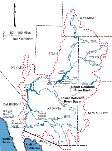
Of the myriad infrastructural life-supports which sustain (1) the city of Los Angeles, the most fundamental is surely the network of canals, tunnels, buried conduits, siphons, pumping stations, and reservoirs which exponentially magnifies the city’s watershed, along three major artificial tributaries. Traced from Los Angeles, the California Aqueduct travels north and west (though the water obviously flows in the opposite direction) to its first pumping station on the San Joaquin-Sacramento River Delta. The Colorado River Aqueduct shoots eastward from the city, to the California-Arizona border, where it meets Lake Havasu at Parker Dam, tapping, through the Colorado River, a vast watershed that extends into Wyoming, Utah, Colorado, New Mexico, Arizona, and Nevada. The third major aqueduct, which is the largest of the three and carries nearly half of the city’s water on its own, is the Los Angeles Aqueduct, which slips out of the Coast Range Province (where Los Angeles lies), through the Sierra Nevada and into the Basin and Range, where it rides north up Owens Valley, where it captures snow melt off the eastern Sierra Nevada and the flow of the Owens River.

[Mono Lake, which lies just north of Owens Lake playa, and is a reasonable approximation of what undrained Owens Lake would have looked like, though it is only two-thirds the size; image via wikipedia.]
This anthropogenic watershed does not extend itself without cost, though. One of those costs, the desiccated and drained Owens Lake playa, is the topic of the first chapter of The Infrastructural City, Barry Lehrman‘s “Reconstructing the Void”. For somewhere around eight hundred thousand years, Owens Lake held salt water continuously, fed by the Owens River. Though it had been slowly shrinking since its formation in the post-glacial period, in the late 19th century, the lake still covered over a hundred square miles, plied by a steamship which ferried goods and raw materials between the Cerro Gordo Mine and Cartago Landing. Construction on the aqueduct began in 1905, was completed in 1913, and had essentially dessicated Owens Lake, through the indirect means of the diversion of the waters which sustained the lake, by 1924.

[A distant alkali dust storm on Owens Lake playa, via wikipedia]
While the playa has never entirely dried out — even at its driest, a salty brine remains below the caked surface — and continues to sustain enormous populations of extremely hardy bacteria (salt-loving halobacteria which produce a striking red coloration) and algae (which produce green coloration), the lake and valley eco-systems were devastated: “lush meadows, sparkling lakes, and the rolling river were replace by the current basin-and-range landscape of sagebrush and sand dunes”. The dried surface of the playa, meanwhile, became a massive ecological disaster, launching polluted dust storms which intensified throughout the twentieth century, as described by Lehrman, speaking here about the state of the playa in the mid-nineties, after environmentalists had pushed for reforms in water diversions upstream:
“Wind gusts above twenty miles an hour lifted over fifty tons per second of ‘Keeler Fog’ off the lakebed. Often reaching over two miles high, these dust storms sent 130 times the United States Environmental Protection Agency’s limit for particulate matter into the atmosphere, blwoing the dust over 250 miles from the lake. Such storms occurred two dozen or more times each year, generally in the spring and fall. Composed of microscopic particles smaller than ten microns (PM10), the dust contains significant levels of toxic metals like selenium, arsenic, and lead along with efflorescent salts. The largest single source of PM10 pollution in the country, these dust storms were a clear threat to the 40,000 people in the immediate region. Even the feds suffered: the dust reduced visibility so badly that nearby China Lake Naval Air Station to the south had to stop flight operations five to ten days each year — costing the Navy over $5 million annually. Physicians at China Lake linked the dust to significant health problems in the region, including higher rates of cancer, lung disease, and eye problems.”
2 According to Lehrman, “the scale of the dust control project on Owens Lake is roughly equivalent to that of a waterworks for a city of over 220,000 people”.
3 That strange apparatus, which Lehrman describes as “rising like alien plants on the terraformed lakebed”, is the subject of an excellent post at Pruned, from last January.
Finally, in 1998, Los Angeles installed a massive (2) irrigation prosthesis in the playa, composed of “over 300 miles of pipe… more than 5000 irrigation bubblers, and hundreds of miles of fiber optic control cables and valves”, periodically watering the thirty dustiest square miles of the playa (3). Now existing in an artificially tensed state, neither truly playa nor fully lake, the lake bed has developed a strange new ecology: “brine flies and microbes” flourish in the “shallow pools” created by the irrigation works, producing a bounty which draws migratory shore birds from the Pacific Flyway.

[Bubblers on Owens Lake playa, via Metropolis]
This landscape is, of course, fascinating in-and-of itself. Within the context of The Infrastructural City, though, it tells a specific story, both about the infrastructural city (in general) and the Infrastructural City (Los Angeles, in particular).
First, as Lehrman notes, the contentious diversion of the hydrological resources of the Owens Valley away from that valley is ironically responsible for the preservation of the rural qualities of the valley, even if those qualities have been radically transformed:
“Once natural, California is now thoroughly artificial. Perversely, only in places as heavily regulated and mechanized as Owens Lake is there any semblance of what the territory might have been like before settlers arrived. In a strange gift, Los Angeles has preserved the open rural landscape of Owens Valley, re-creating the void where by all rights we shouldn’t expect to find it.”
Similarly, adjacent Inyo National Forest — an apparently fully preserved natural landscape — is also a relic of the city’s thirst for water, having been created by the federal government at the behest of the city, which petitioned for its creation and expansion so as to preserve the watersheds which supply the Owens River. While the creation of natural preserves is usually thought of as a mechanism by which to prevent the exploitation of an ecosystem, in this case the natural preserve is, functionally, as much a part of the hydrology and ecology of Los Angeles as the thoroughly channelized Los Angeles River or the LADWP aqueducts, illustrating a fascinating overlap between the economic incentives of development (which would not be possible in greater Los Angeles without water which is ultimately derived from Inyo) and the ecological imperatives of preservation.

[Rows of native salt grass, planted by the LADWP as part of remediation efforts at Owens Lake, via Metropolis.]
This functional integration between urban and rural systems indicates a second lesson, which is that it may well be worth re-learning the original definition of urbanism:
“…Whilst contemporary definitions focus heavily on the impact of built-form on cities, the original meaning [of ‘urbanism’] was coined by Ildefons Cerda to describe “the science of human settlements at various scales and times, including countryside networks”. Although Cerda’s original definition referenced natural systems, the impact or understanding of these systems’ influence on built development (and vice versa) appears to have been lost in contemporary definitions.” (Christopher Gray, “Turning the field: contradictions in landscape urbanism“, in Kerb 15)
While the common tendency is to read “urban” as an adjective which is applied to territories in direct correlation to both density of settlement (thus downtown is very urban and suburbia is less urban and a farm is not urban at all) and the absence of natural ecological systems (though, of course, ‘natural’ is itself a cultural construct), the design of cities requires a continual awareness of the tentacular extension of the effects of urbanization into distant terrains. After nearly 100 years of serendipity, greed, and lawsuits, the Los Angeles Aqueduct, Owens Lake playa and Inyo National Forest have evolved into a fascinating cross-section of anthropogenic landscapes, varying in degree of human influence, but all functioning in concert to support a heavily developed urban region. Much as mammoth has recently argued that the iPhone cannot be understood without understanding its participation in a diverse series of physical terrains, the infrastructural city too begins with distant landscapes, and an understanding that Owens Lake playa, with its weird, manufactured ecosystem, is as much a part of Los Angeles as Mulholland Drive is.
Further reading:
David Maisel’s Lake Project uses Owens Lake as the site and subject of a series of stunning photo-essays. Geoff Manaugh interviewed Maisel for Archinect, and there’s an extended interview in the BLDGBLOG Book. DPR-Barcelona posted about the Lakes Project towards the end of last week.
Metropolis visits Owens Lake with CLUI, and CLUI provides an extended field report on that excursion, which includes travels up and down the Owens Valley.

Hi friends
We just found out that Alexander Trevi from pruned was participating in the discussion just a year before we started [Déjà-vu]
Interesting article about the Owens Lake chapter, focused in the dust control system:
http://pruned.blogspot.com/2009/01/rising-like-alien-plants-on-terraformed.html
Yup! It’s a great post.
This is spot on; the Cerda definition of urbanism has such power because of its sensitivity to the many underlying landscape and ecological processes which influence settlement regardless of scale. It is a sensitivity which is frequently lost in contemporary practice.
Cerda’s definition was recently discussed (briefly) on BBC Radio 4’s “In Our Time” with Billy Bragg (http://www.bbc.co.uk/programmes/b00rfhx2) which if you are very quick you may just be able to catch again.
Thanks for the pointer to my Kerb article; I’m looking forward to the ongoing discussion on the Infrastructural City!
Thanks for the pointer to the BBC discussion, Christopher.
Obviously, there’s a lot we haven’t gotten into in this post (such as: tension between conceptions of artifice and nature, which we hinted at but didn’t address directly; Lehrman’s discussion of the implications of the history of Owens Lake for the future water supply of Los Angeles — a discussion which one might easily relate to mammoth‘s previous discussion of the Orange County Groundwater Replenishment System, where we suggested that the city might be seen as a “stillsuit”; what our responsibilities are to the weird ecologies our infrastructures produce, which will also be discussed in the next chapter; and, of course, how a designer should act in the midst of this sort of situation — a topic which Lehrman’s post about writing the chapter gets into a bit), but don’t let that hold anyone back from discussing it.
[…] edited by Kazys Varnelis and central point of a chapter-by-chapter reading and discussion hosted by mammoth. Although water once flowed into the lake from the Owens River, the lake eventually became […]
Massive diversions of water in northern California has attained the status of “best practice” in water management. This practice runs contrary to sustainability as an underlying principle of water allocations. Water politics in this state is focused in a state legislature that is not reflective of the needs of users.
Not mentioned in this narrative is the battle waged by agricultural and ranching users in the Owens Valley region that reached the level of armed conflict. Unless a new model, based on adaptive governance and regional water planning, is adopted throughout the state of California, the political influences of southern users will continue to have their way.
States, such as Texas, have demonstrated the effectiveness of regional water plans and have increased the ability of local users to construct plans based on regional supplies. The issue is how can we establish processes that protect the the needs and concerns of local users, address the hydrological and environmental ramifications of decisions when others are free to come in and open the spigot for others. At what point do decisions that rob one region of the water resource for the benefit of others reach the level of being arbitrary and capricious? Why are voters throughout the state empowered to make the decisions that will not impact on their lives?
Underlying the questions is how we try to learn the lessons from the Owens Valley experience. It’s all very good for us to aesthetically gaze on the remarkable changes in Owens Lake ecosystem. It’s another thing to incorporate the reasonable concerns of users who are robbed of their needed resource as a vital component before decisions concerning diversions are made.
Thanks for the comment, Martin.
The last thing we would want to do is merely “aesthetically gaze” on Owens Lake! Though I won’t deny that mammoth has a bit of fascination with weird and broken ecologies, our fascination has as much to do with the histories, functions, and futures of those ecologies as it does to do with their aesthetic properties.
It is quite true that this post skipped over the Water Wars and the ethical ramifications of the diversion of water which collects in the Owens Valley to Los Angeles, but it should be noted that a discussion of both the history of conflict over water rights in Owens Valley and of the contentious future of southern California’s demands for water is part of the text which we are reading, so the issue has by no means escaped our notice.
You raise a very interesting and difficult question, which is how best to balance the water needs of a distant majority with the obvious economic and environmental water interests of the localities that they obtain their water from.
I’m curious what your proscription for resolving that tension would be — it seems to me that you feel the decision-making process is rigged in a way that disadvantages the Owens Valley (which, historically, is obviously accurate), but what does a more just allocation look like to you?
I’m not familiar with Texan regional water plans, but I’d be quite curious to learn more, particularly if those plans do demonstrate a more equitable resolution of this tension. Can you point us towards a source that discusses them?
Thank you for your response.
As a participant in the Middle Rio Grande regional planning process, I spent close to ten years working in a model of ecological democracy in the Albuquerque-Rio Rancho region of NM. I would point you to the website of the Middle Rio Grande Water Assembly as a specific model in which I was engaged. The website is: http://www.waterassembly.org The plan is accessible on the Home page.
My reference to the Texas plan is a result of the frequent news articles that have appeared in regards to the updates that are ongoing in Texas. Also, as good as the process was in the Middle Rio Grande, it failed in the implementation stage because municipalities failed to utilize its recommendations and overview. Despite the fact that governmental entities, irrigator associations, county commissions and flood control agencies signed off on the plan before it was submitted to the Interstate Stream Commission, the Bernalillo County Commission was the only entity to reference the plan in its water conservation ordinance.
As a Green urban user, I spent much time on the Urban Users and Economic Development Advocates’ committee that was represented on Action Committee. As a member of that committee, I represented Green [Party] urban users and sought to integrate quality of life issues with the plan’s recommendations and preferred scenario.
The reason for this is a political issue. As users in California know, those making the decisions are not those impacted the most by them. The planning process in California is top-down and has little real authority in regards to establishing regional water budgets or Public Welfare statements. Its advisory character is directed towards a state plan that remains weak and undirected in regards to regional users, the science and the environment. Furthermore, the state legislature continues to undermine regional planning through inter-regional diversions to both urban and rural users in southern California. Likewise, the oveerlapping jurisdictions and conflicting agencies continue to make water management and administration a Gordian knot if we were to establish adaptive governance and regional planning as the underlying principles.
“if we were to establish adaptive governance and regional planning as the underlying principles.”
should read “UNTIL we slice through it by establishing adaptive governance and regional planning…”
The planning template provided to the 16 planning regions in NM by the Interstate Stream Commission included a stipulation for regions to provide a plan that was not dependent on transfers from other regions in order to be balanced.
The goals of the MRG plan included a stipulation to “balance growth with renewable supplies” that was opposed by the WRB of the Middle Rio Grande Council of Governments thereby making an administrative body of the local municipalities a significant obstacle in the implementation of the regional plan. (see section 1.3.3 of the plan http://www.waterassembly.org/archives/MRG-Plan/D-Rio%20Grande%20Plan/CH01-Introduction.pdf )
Thanks, Martin. We appreciate you taking the time to relay your experiences and providing us with a first-hand account of the politics of hydrology, attesting to the importance of good, responsive governance and transparent planning processes (through what sounds like their unfortunate absence).
From the executive summary, it looks like the Middle Rio Grande plan was a very reasonable document.
These are exactly the sorts of issues which architects and landscape architects need to be able to negotiate successfully and publicly (and ethically!), if we’re going to contribute to the planning, design, and re-design of large-scale infrastructures.
[…] is appropriate. Consequently, we default towards stasis and seek to avoid flux. But just as we’re discovering that this isn’t appropriate ecologically, might it also be inappropriate […]
[…] other words, not only is Wyoming in Los Angeles; but America is in Canada, or Canada is in America, or both at the same time. This entry was […]
[…] is supported (as we’ve noted before, after Christopher Grey) by the definition that Ildefons Cerdà provided for urbanism when he […]