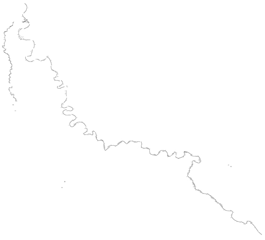
[Map of revetments under the purview of the Army Corps of Engineers’ Team New Orleans, on the Mississippi and Atchafalaya Rivers; image produced by mammoth using data from the Army Corps.]
I’ve already talked a fair about the idea that the Mississippi River is, at this point in its history, an artificially-constructed system that should be understood as a hybrid of infrastructural and natural forces. So far, though, I’ve explained this primarily in macroscope terms, such as by noting that the flow rates of the river are artificially bounded and increased, or that the position and magnitude of flood events are produced by a confluence of natural forces, politics, and engineering — the river overlaid by “a diagram with… persistent instrumental effect”, in Brett Milligan’s apt description.
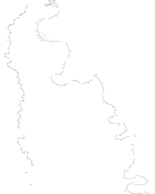
[Zooming in further on Atchafalaya and Mississippi revetments.]
The Mississippi, though, is also materially artificial, to a degree that may be quite surprising and, frankly, intensely weird. The entire lower reach of the Mississippi has undergone the process of “channel stabilization”, which includes dredging (to improve navigability and maintain consistent channel depth), building dikes, providing cutoffs (artificially dug straight paths for the river which anthropogenically accelerate the production of oxbow lakes), and, most importantly for the alteration of the river as a channel of sedimentary material, the construction of “revetments” on the majority of the river’s banks1.

[Revetment mapping, close-up. The extent of the material application of the concrete mats — the sheer scale of the transformation of the Mississippi from a soft system in perpetual erosive motion to a semi-hard system, locked in place — can be felt in the completeness of the trace of the river’s form.]
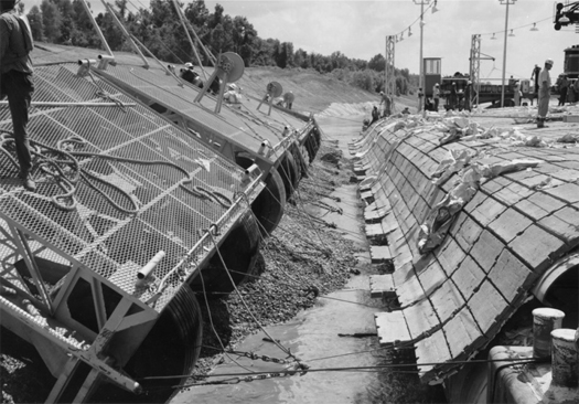
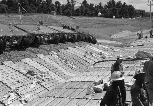
[Constructing the Goldbottom revetment in Mississippi, 1964; images via the Public Library of Cincinnati and Hamilton County.]
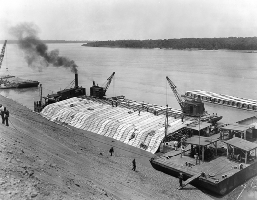
[Lowering a revetment onto the “subaqueous stream bank” near Memphis, Tennessee; via the Public Library of Cincinnati and Hamilton County.]
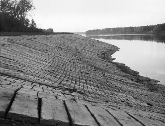
[A finished revetment in Kentucky; via the Public Library of Cincinnati and Hamilton County.]
The revetments seek to freeze a specific temporal and spatial moment in channel migration for apparent perpetuity, encasing soft earth in hardened cement and aggregate; they are most often placed on the outside banks of bends in the river, where the erosive action of riverwater is concentrated. (In alluvial flood plains, like the Mississippi’s, rivers are ever migrating (meandering) towards their outside bends, producing “cut banks”, while depositing material on their inside edges, producing “point bars”.)
In Mississippi River channel stabilization, these revetments are most typically constructed out of “articulated concrete mattresses”, vast mats of interlocked concrete blocks which are laid onto banks by special “launching barges”.
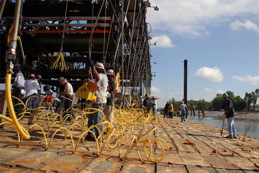
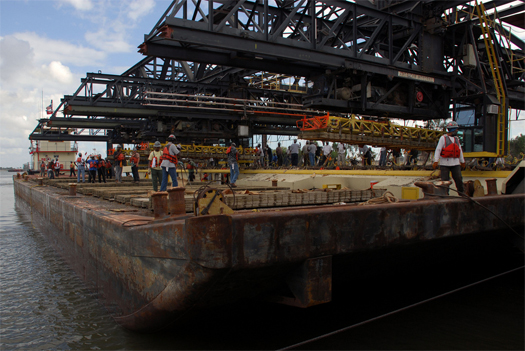
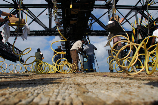
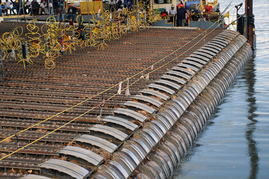
[The “Mat Sinking Unit”, in operation, Fall 2010.]
The Army Corps of Engineers describes the operations of the “Mat Sinking Unit”, the Vicksburg District’s mat launching barge:
“Each autumn the Mat Sinking Unit, with over 350 employees, begins several months of work on the Mississippi River for the annual construction program of establishing permanent locations for the constantly moving river banks using flexible concrete blankets. The designers allow the river to eat away at the banks until they arrive at the desired position and at that point, they are fixed in place…
Mat sinking is not an 8-to-5 job, but rather, seasonal work conducted during the traditional low water months of August, September, October and November. When the workers leave Vicksburg on the quarter boats, compared by some to a large, floating hotel, their work season consists of 10-hour shifts for 12 consecutive days with two days off. This mat sinking operation is a unique river operation and is the only one of its kind in the world.
The articulated concrete mattress (mat) arrives on location by barge from one of the mat-casting fields along the river in Tennessee, Arkansas, Mississippi and Louisiana. A fleet of 50 mat supply barges, some loaded and on location and some empty and awaiting loading by the mat-loading crew at the casting field, are towed up and down the river by Corps or contract boats.
On location, the mooring barge and spar barge are perpendicular to the shore and the work barge (mat boat) is parallel to shore and tied off to the mooring barge. The work boat positions a supply barge to be tied off to the back of the mat boat and the mat-laying operation is ready to begin.
The four overhead cranes move the 16-block sections of mat from the supply barge across to the mat boat where workers, using a pneumatic “mat-tying” tools, wire the sections together and connect to 3/8-inch launching cables running from the mat boat to the bank. The 4- by 25-foot sections (squares) are tied together with 35 other squares to form one launch. A typical blanket of mat will consist of from 12 to 24 launches. Each supply barge holds 585 squares of mat, consisting of 950 tons of concrete.
In order to get the mat anchored firmly on the bank, anchors are driven in the ground. The crew will hook the mat cables to dozers (tractors) waiting on shore that serve at temporary anchors. The mat boat will then move away from the bank launching the concrete mattress in the process. The mat boat can move riverward [along the] mooring barge and then spar barges are utilized to allow the mat boat to continue out for the remainder of the channel mat length. The entire plant moves upstream… and begins the first launch of a new channel mat.”
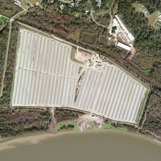
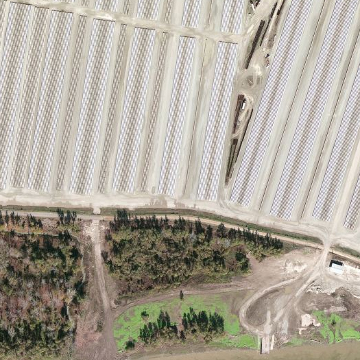
[The St. Francisville Casting Fields, via Bing Maps.]
The blocks for these articulated mattresses are cast at several locations along the Mississippi River, such as the Army Corps’ St. Francisville Casting Fields, an obscure facility in West Feliciana Parish, Louisiana, composed of a dock (where the barges are loaded) and the 210-acre casting field, from which the Army Corps accomplishes the exceptionally bizarre task of creating and exporting artificial banks for America’s greatest river, in a fascinatingly quick and hard anthropogenic twist on the processes of sedimentation which slowly form natural river banks. A couple more of these fields of future river bottoms, which are spread throughout Louisiana, Arkansas, Mississippi, and Tennessee, can be found on the Mississippi Floods map.


What I would be interested in knowing is whether each mat is specific to the location in which it will be emplaced. Meaning is it like a mini map of the particular bank (a small scale version of the previously discussed river models) or if it is a standarized thing that perhaps changes in size if at all.
The way I understand it, it’s site-specific in the same way that a tarp is site-specific — it’s a standardized mat that is flexible enough to (roughly) assume the shape of whatever it is applied to.
Which makes it a fascinating mid-point between soft and hard infrastructures, with some of the characteristics of both.
[…] home // hide asides // links // index.archive // contact us // about « casting fields […]
Wonderfully illustrated. I’m particularly intrigued by the Mat Sinking Unit as embodied infrastructure and meta-logistical inspiration for architectural speculation and/or fiction. Like I wonder what Anthropologist Marc Augé might say or come up with(in elaboration of his notion of “non places”) if he was supplied with a copy of Twain’s Life on the Mississippi while spending a seasonal stint upon the barge.
Yeah, there’s this weird mixture of the epic and mythic with the prosaic in the work of the Mat Sinking Unit, that I probably didn’t capture very well, but which I do think would lend itself to such a speculative or fictional treatment.
Probably the mode of infrastructural realism that I’ve been in with the whole flooding series has held me back from properly translating (or extending, Future Plural-style) the weird, weird quality of these landscapes.