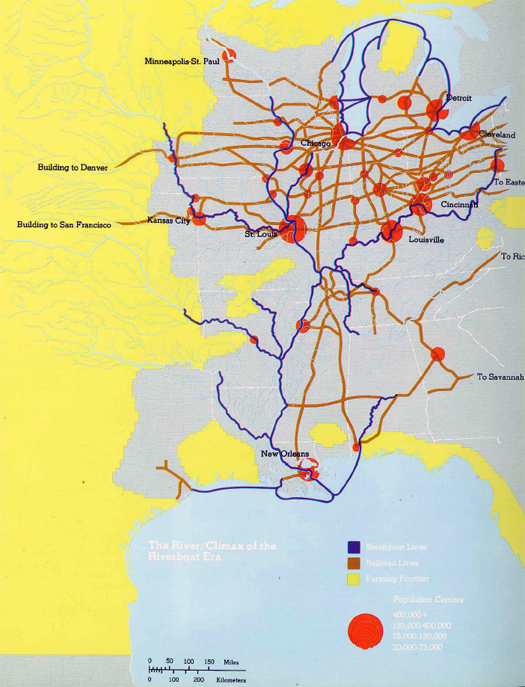
Over the course of this summer’s discussion of floods, we’ve talked a great deal about channelization and levees and dredging and the other acts of industrial landscaping that have produced the riverine landscapes of the Mississippi watershed. Those acts, though, are multi-purposed: they are executed to control floods, yes, but they are usually also intended to improve the capacity of the river systems to carry goods — rivers as industrial infrastructures.
This role has been essential in defining the Mississippi and valley landscape since European colonization. The image above — from The River: Images of the Mississippi, which documents an exhibition at the University of Michigan’s Walker Art Center in the seventies, found and sent to us by reader Erik Prince — compares the great dendritic network of the Mississippi and its tributaries with the rail network that first augmented and then replaced it. (Though the key is unfortunately nearly unreadable, it is hopefully clear that riverboat lines are in blue, railroads in brown, and urban centers in red.) In the accompanying text, geographer John Borchert writes:
“The year 1868 was near the climax of the riverboat era. Registered tonnage of general-purpose packet steamers on both the western rivers and the Great Lakes had risen rapidly since the 1820s and it was to reach its peak in the census year of 1870. St. Louis, at the confluence of the Missouri and Mississippi, was the fifth largest metropolitan area in the nation. The city was the hub of a network of scheduled riverboat lines that reached to St. Paul, Peoria, Sioux City, Pittsburg, Nashville, Muscle Shoal, and New Orleans. St. Louis still vied with Chicago as metropolis of the West. Up the Ohio, Cincinnati was the nation’s seventh largest urban area; and Louisville was much larger than most midwestern cities. Dubuque, Keokuk-Fort Madison, and Quincy — all upper Mississippi River towns — were among America’s hundred largest urban areas; Peoria and Davenport-Rock Island ranked in the top 50.
Interesting oddities in the rail pattern still reflected its early role as a supplement to the basic river and lake routes. The Illinois Central listed its “main line” as the route from Galena through Decatur to Cairo, and its “branch line” to Chicago! The Midwest-New Orleans route included a 20-mile steamer link from Cairo to Columbus, Kentucky. The whole national “system” actually consisted of dozens of separate companies with connections of varying quality.
But the handwriting was on the wall. The river system was essentially as large as it would ever be. Meanwhile, the rail net was growing swiftly, and its relatively straight lines were everywhere bypassing and shortcutting the slow, twisting river routes. In the next half-century Chicago would add 2,500,000 residents, while St. Louis would add 500,000. Soon after the date of this map, St. Louis entrepreneurs would awaken to their growing locational disadvantage in the new era. They would build the Eads Bridge — engineering marvel of its day — to link their economically threatened riverfront with the burgeoning eastern rail system, and organize the densely spaced, misnamed Missouri Pacific rail lines to hold their trade territory that reached southward to the delta. Even so, St. Louis would drop sharply in the national rank order of cities, never to recover its former position. So, too, would Louisville and many of the smaller river cities such as Dubuque and Quincy. New Orleans would fall back sharply, but recover in the auto era, when oil would bring unprecedented boom times to the Gulf coast.
Thus, at the time of this 1868 map, the river’s role was about to shift from what it had been in pioneer times toward what it would be in modern America.”
This is the Mississippi as a generative infrastructure, instigating patterns of settlement that continue to govern the urbanisms of middle America even as the Mississippi is greatly diminished in relative importance as infrastructural backbone. Thus — quite ironically — it is the efficacy of the Mississippi in generating urbanisms, an expression of the quantity and intensity of agency the river is capable of exercising to the end of making landscapes, that led to its subjugation via channelization and regularization, as the river made the riverboat system possible, the riverboat system begat settlement, settlement requires protection, protection requires flood control, and flood control reduces the capacity of the river to make landscapes.


Note that at least some times of the year boats made it to Fort Benton, MT, (before the railroads got to MT). I suspect steam boats made it further up the Tennessee river as well. Note that today they can get to Knoxville, on the Arkansas navigation extends as far today as then (Basically Tulsa, Ok, and today you have Navigation to near Birmingham, Al as well as the Tenn Tom waterway. The Missouri navigation as shown is basically todays navigation. Note that for example in the 1850s steamboats went up and down parts of the Des Moines river also.
[…] home // hide asides // links // index.archive // contact us // about « “the climax of the riverboat era” […]