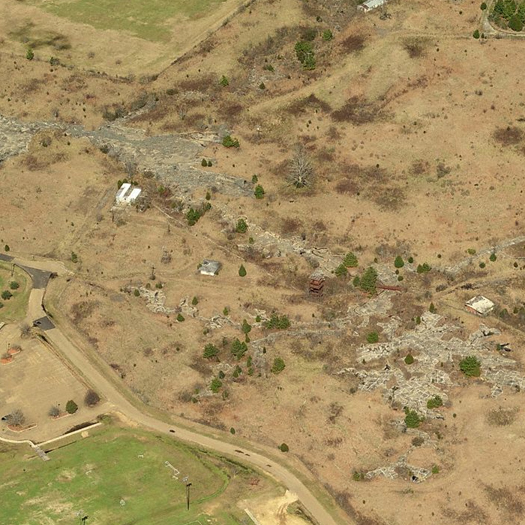
[The Mississippi River Basin Model today, via Bing Maps.]
At Places, Kristi Dykema Cheramie writes about the one of Mississippi flood control’s most fantastical landscapes, the Basin Model — “a 200-acre working hydraulic model [replicating] the Mississippi River and its major tributaries — the Tennessee, Arkansas and Missouri Rivers”, on a small tract of land just outside of Clinton, Mississippi. Cheramie’s piece is worth reading in its entirety (her observation that the model cuts off at the Old River Control, eliminating the entire delta landscape from the modeling of the river, for instance, is extremely important, as it shows the feedback between how the river is conceived and how the river is constructed), but I’ll quote one short section, which recounts the first operational activation of the model:
“On April 1, 1952, George Stutts, a Missouri River engineer, conducted his regular field surveys of the levees in Nebraska and reported that northwest Missouri was in “no immediate danger of flooding.” [20] Only seven days later, a new survey indicated signs of imminent and severe floods. The mayors of Omaha and Council Bluffs contacted the Army Corps District Office to propose using the basin model to predict flood stages, and the model was called into active duty for the first time.
On April 18, as the Omaha World Herald rolled out the headline “Missouri River Near Crest Here; Anxious Eyes On Soggy Levees,” the basin model was halfway through 16 days of continuous 24-hour tests. Engineers issued prototype conditions to the newly installed instruments, generating simulations that forecasted likely events over the next month — crest stages, discharges, levee failure and more. As water poured through the Missouri River section of the model, the resulting data were relayed directly to aid workers in Omaha and Council Bluffs, who were able to respond with brigades of civilians and sandbags to points where levees needed to be raised only slightly; areas predicted to flood dramatically were evacuated. In total the Mississippi River Basin Model prevented an estimated $65 million in damages. [21]
With this impressive victory against the river, Reybold’s project was vindicated. The model had allowed the Mississippi River Basin to become, for the purposes of study, an object, a manageable site. Here engineers, community leaders and civilians could gather to discuss the potential ramifications of particular flood control measures and forecast likely scenarios. Each gallon of water passing through the model was the equivalent of 1.5 million gallons per minute in the real river, meaning one day could be simulated in about five minutes. This allowed for a tremendous capacity to collect data, to use the model as an active tool for communication, and to distribute information about the river as a system. With mayors from cities up and down the river gathering in the observation tower to watch the Mississippi cycle through an entire flood season, it became possible to find edges, limits and centers, to see how and where the river might strike next. The model imbued the river with a reassuring degree of certainty. Policymakers began to adjust to a new scale of thinking.”
Read the full piece at Places.


[…] home // hide asides // links // index.archive // contact us // about « the mississippi basin model […]
[…] of the Army Corp's Coastal and Hydraulics Laboratory. (It also is the entity which operated the Mississippi Basin Model, and the research into flood control and river hydrology which was once conducted physically on […]
Heya i am for the primary time here. I came across this board and I in finding It really useful & it helped me out a lot. I hope to provide something back and help others such as you helped me.