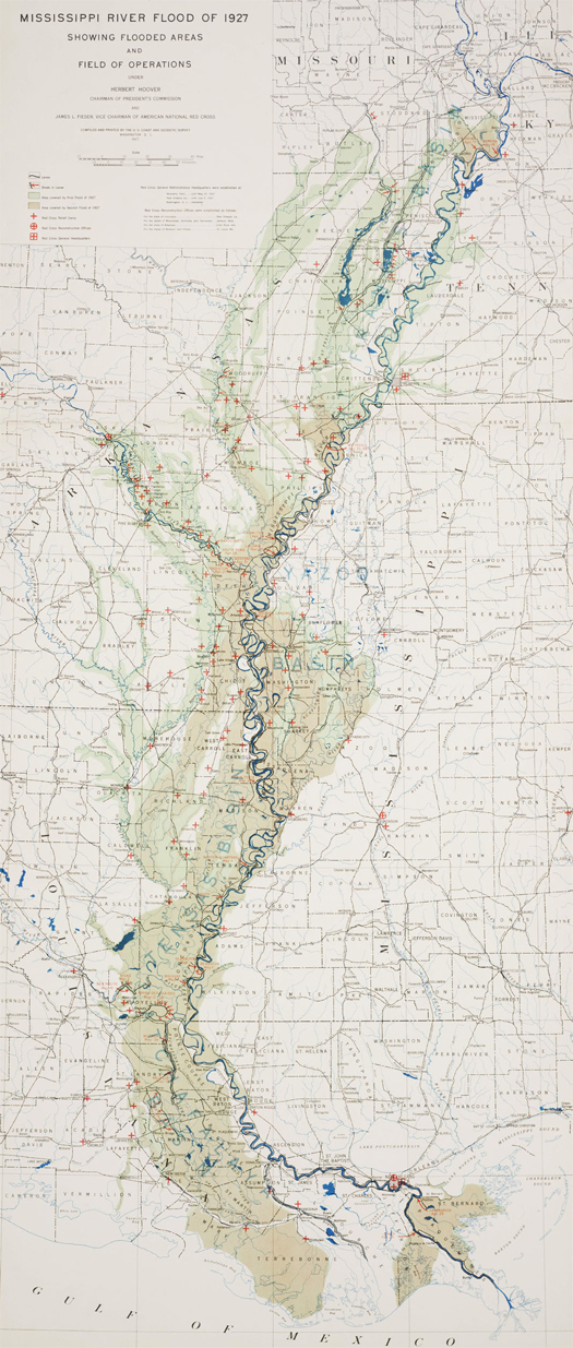
[Map prepared by the US Coast and Geodetic Survey (the fore-runner of today’s National Oceanic and Atmospheric Administration) in 1927, after the Great Mississippi Flood of that year. The map shows “flooded areas and the field of operations”. The great devastation produced by the 1927 flood — it flooded an area approximately equal to the entire area of New England, displacing nearly a million people — prompted Congress to pass the 1928 Flood Control Act, which authorized the Army Corps of Engineers to survey, prepare flood control plans for, and erect bigger, stronger, more complex flood control infrastructures along the courses of the Mississippi, its tributaries, and the Sacramento River. View the full-size map here.]
-
recent posts
- mud and oil
- dredgefest california
- prosthetic landscapes in a time of acceleration
- Excavations, Shockwaves, and Limits
- on landscape science
- sea ice small multiples
- the dredge underground
- the five thousand pound life: land
- suburban futures
- pilot projects
- landmarks
- territorial reclamation
- landscape information modeling
- mesosphere excavations
- semipile
-
recent comments
- rholmes: Thanks for your comments, all. Brian: I look forward to your further thoughts on my first two points. Where...
- Michael: A little late to the party but here nonetheless. Needless to say I’m quite sympathetic to the pursuit...
- building nothing out of something: 30;] home // hide asides // links // index.archive // contact us // teaching //...
- Brian: well, there are few things more gratifying than producing something that people I admire and draw from engage...
- Brett: So it seems it would be great if the new Places interface could include a comment forum to give the authors...
- Ryan Lee Waldron, PE: I don’t think Landscape Architecture should be renamed landscape science, just as I...
- Alan Wiig: For whatever reason, when reading this commentary I thought of John McPhee’s book The Pine Barrens,...
- Julian Raxworthy: Interesting discussion Rob, and great to be referred to and introduced to your blog. Reading this...
- Thoughts on Everything under the Sun or I am a guilty Secularist: 30;] h/t m.ammoth.us […]
- Anchorite: If NM fails to meet its water obligations to TX they don’t pay a simple penalty, a federal judge...
-
monthly archives
-
category archives
-
tags
anthropocene architectural-criticism architecture army-corps-of-engineers atchafalaya china climate-change competitions dredge dredge-research-collaborative ecological-urbanism-at-gsd economics flood-control geology glacier-island-storm hacking-infrastructure hydrology infrastructural-vernacular infrastructure internet iphone kazys-varnelis landscape landscape-architecture landscape-futures landscape-infrastructures landscape-urbanism los angeles louisiana mississippi-river networked-urbanism new-urbanism new york city photography post-industrial re-industrial reading-the-infrastructural-city readings soft-systems suburbia technology transportation urbanism video-games waste


[…] home // hide asides // links // index.archive // contact us // about « the mississippi river flood of 1927 […]
love the fact that the map had in it’s title Field of Operations… I assume they are referring to the river’s Field of Operations? Or is it the Corps field of operations in response? Although they may in fact i suppose be the same thing.
Pretty sure its referring to the Corps’ field of operations, but, yes, it’s excellent.
[…] the mississippi river flood of 1927 […]