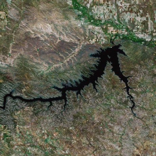
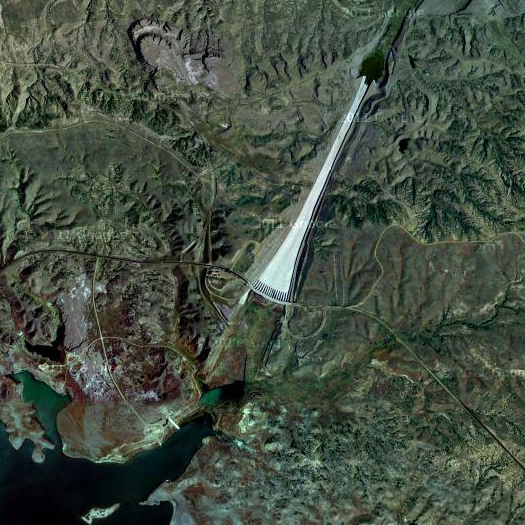
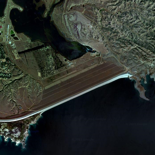
[Fort Peck Lake (top), Spillway (middle) and Dam (above), in northeast Montana; built between 1933 and 1940, Fort Peck is the world’s largest “hydraulically-filled” dam, which means that it was constructed by dredging suspended sediment from borrow pits and pumping it to discharge pipes at the dam site, where it settles onto the embankment. (This method of construction is rarely used today, as it can be extremely unreliable; in fact, the Fort Peck Dam suffered a major failure during construction, in 1938.) The lake the dam creates is the fifth-largest in the United States, and has a coastline longer than that of California’s Pacific coast. Currently, the dam is releasing water at around 65,000 cubic feet per second — nearly double its previous highest release volume.]
As I mentioned back in May, massive snowpack in the Rockies is melting to produce volumes of water that will continue to push unprecedented levels of runoff through the river systems that drain the western United States throughout the summer. Burdened by this snowmelt, the six reservoirs of the Upper Missouri — Fort Peck Lake, Lake Sakakawea, Lake Oahe, Lake Sharpe, Lake Francis Case, and Lewis and Clarke Lake — are exceptionally full, and the Army Corps of Engineers has decided it must release unprecedented volumes of water from those reservoirs for the remainder of the summer.
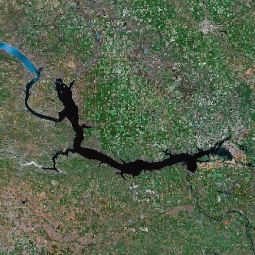
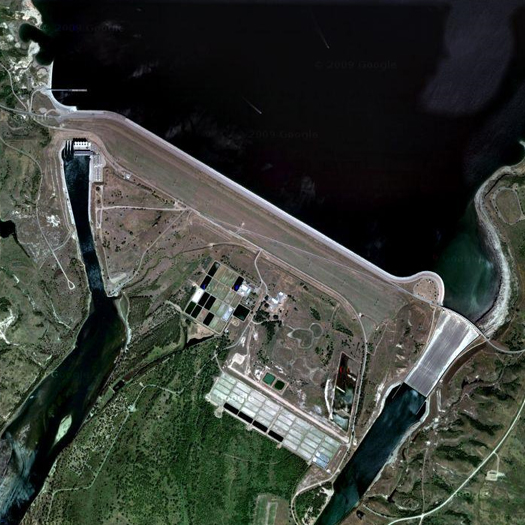
[Lake Sakakawea (top) and Garrison Dam (above), in western North Dakota. Sakakawea is the nation’s third-largest artificial lake, while Garrison Dam is, like Fort Peck Dam, a massive earthen embankment. In the image above, two features deserve comment: the spillway, which is on the lower-right side of the dam, and the Garrison Dam National Fish Hatchery, which supplies some 10 million fish annually, including salmon, trout, and the pallid sturgeon, to rivers and lakes in North Dakota, Wyoming, Idaho, Nevada, South Dakota, and Montana. Being downriver from Fort Peck, Garrison Dam sees a greater volume of flow, and so is releasing around 150,000 cubic feet per second, nearly three times what Fort Peck is releasing (and, coincidentally, also nearly three times its previous record release).]
Like the Mississippi River, which it feeds into near St. Louis, the Missouri River is a complex, hybridized infra-natural system. The riparian ecology of the Missouri’s floodplain has been almost entirely eradicated, as forest cover dropped from a high of 73% in 1826, to a mere 13% in 1972; in many places, this represents a mere single row of trees along each bank. The historic diversity of ecosystems — “a ribbon of islands, chutes, oxbow lakes, backwaters, marshes, grasslands, and forests” — has been replaced largely with the incredibly productive agricultural plots which appear as pixelation in the satellite images above and below. Though the destruction of arable land by sediments deposited during and erosion caused by the great floods of 1993 and 1995 has led to a trend towards the purchase and re-naturalization of floodplain land, the general condition remains agricultural rather than riparian. The river’s tendency to meander has been nearly eliminated, and the river has been confined “to a narrow floodplain approximately ten percent of its original width, [eliminating] side channels, quiet pools, isolated backwaters… and associated wetlands”.
The river itself has been massively altered, as well. “Nearly one-third of the Missouri River has been impounded, another one-third channelized, and the hydrologic cycle… has been altered on the remainder”. The river’s traditional cycle of ebb and flow — of both water volumes, which used to peak twice a year, in spring and early summer, and sediment levels (the river’s nickname was once “the Big Muddy”) have been interrupted by the presence of that impoundment and channelization. (The river carries approximately a third to a fourth of its original sediment load.) With erosion and deposition disrupted, the channel has degraded, as the river cannot cut side to side, and so cuts deep into its own bed; in achieving an equilibrium of flow — flattening the peaks and valleys of water flow in order to dampen flooding and combat drought — the dynamic equilibrium of sediment has been lost, and between the loss of shallow habitats (as the main channel deepens, its capacity to feed shallow bottoms around the main channel is reduced) and the alteration of hydrological conditions (temperature, seasonal flow variations, etc.), the river’s stocks of native fish have been devastated.
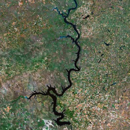
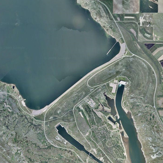
[Lake Oahe (top) and Oahe Dam (bottom). Even as artificial lakes on the upper Missouri go, Lake Oahe is an exceptionally long and thin lake, stretching around 231 miles from just south of Bismarck, North Dakota to Pierre in central South Dakota. Like most (all?) of the dams on the upper Missouri, Oahe Dam is pair with a major hydroelectric plant; the Oahe Plant sends power to Nebraska, Minnesota, Montana and North and South Dakota.]
Like the Misssissippi River, the infrastructural components of that system were constructed, are maintained, and are operated by the Army Corps of Engineers. But where the Mississippi falls under the authority of the Mississippi Valley Division, the Missouri — despite the connectedness of the two rivers, which form a single continent-spanning watershed — is watched over by the Northwestern Division, whose purview stretches from the mouth of the Columbia on the Pacific, across the Rockies, and east along the Missouri. Within the Division, two districts have specific responsibility for the Missouri: the Omaha District, which is responsible for the upper river (from Montana, including both of the Dakotas, and through Nebraska and Iowa), and the Kansas City District, which is responsible for the lower Missouri.
The six dams and reservoirs on the upper Missouri (and thus in the Omaha District) together comprise the largest system of reservoirs in the United States. The first of these, Fort Peck Dam and Lake, was constructed by the Public Works Administration during the Great Depression. The other five — all downstream from Fort Peck — were constructed under the “Pick-Sloan plan”. While the Army Corps began removing snags from the river in the 1820’s to improve navigability, and received funding from Congress beginning in 1881 for various projects on the Missouri, including dikes and piers to divert the river’s flow, clearing snags, and a permanent six-foot channel from Sioux City to St. Louis, it was the Pick-Sloan plan, approved in 1944, which initiated the modern era of Missouri River infrastructure. The plan authorized over a hundred reservoirs within the Missouri basin, “but its cardinal feature was the integrated multi-purpose plan for five additional main stem dams”, “giant mounds of compacted earth [forming] a series of reservoirs with a storage capacity of more than 74 million acre-feet and a surface area of over one million acres”.
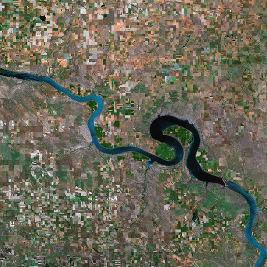
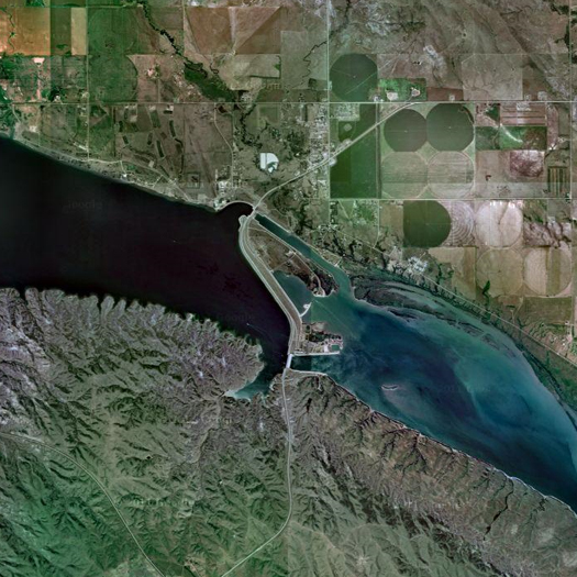
[Lake Sharpe (top) and Big Bend Dam (above); like the other four main stem dams, Big Bend is currently releasing over 150,000 cubic feet of water per second. Big Bend was also the last of the six major dams to be completed.]
While we now know that the construction of this infra-natural system has had a host of negative consequences (specifically, the ecological and geomorphological consequences outlined above), it was proposed and built in response to very real problems, and its success in addressing those problems should not be minimized. As World War Two raged, planners considering the future of the Missouri basin confronted multiple challenges: frequent flooding endangered lives and destroyed valuable crops; at other times, severe droughts could be just as destructive — if not more so — to agriculture, making the livelihoods of farmers in the basin precarious; and farmers were rapidly leaving farms for urban areas, a trend that was accelerated by the movement of populations in response to wartime economies. New Deal Democrats were determined that returning soldiers not come home to depressed economies and historically-low crop prices, as they had at the end of World War One. Flooding in 1943 emphasized the urgency of these needs, and General Lewis Pick — the Missouri River Division Engineer — and Glenn Sloan, of the Bureau of Reclamation, proposed a pair of plans which was soon combined into a single initiative that bore their names. Construction of the main stem dams began in 1947, with Garrison Dam, and finished in 1966, with the completion of the power plant complex at Big Bend Dam. The plan had four aims: flood control, navigation, irrigation, and hydropower; and if it was not an unqualified success (it was not), it certainly produced clear benefits in each of these areas.
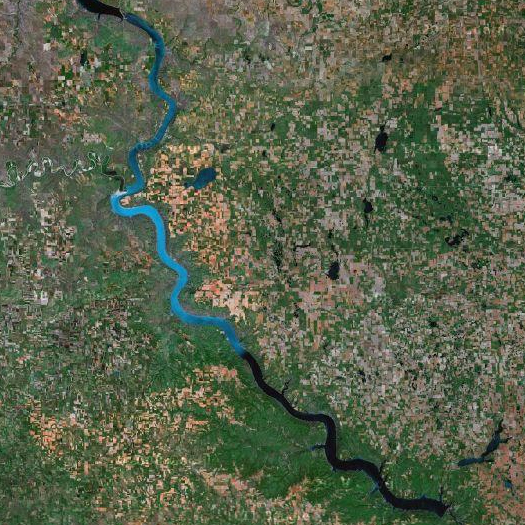
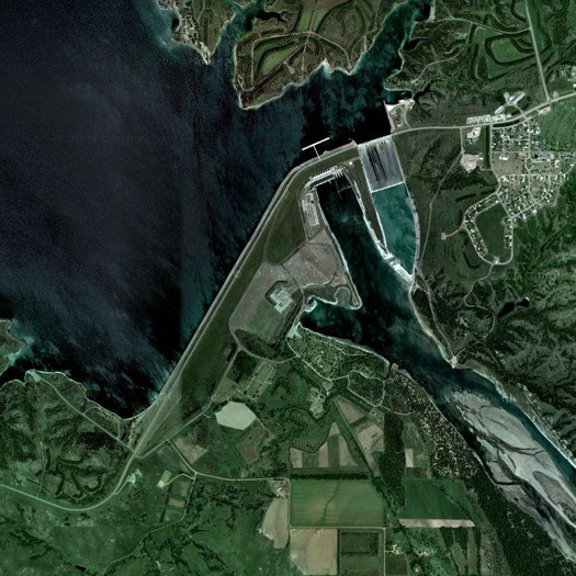
[Lake Francis Case (top) and Fort Randall Dam (above); note that Big Bend Dam is visible at the northwestern terminus of Lake Francis Case, as the lake stretches contiguously from one dam to the next.]
Today, the operations of the Army Corps of Engineers are coordinated with the Fish and Wildlife Service, as the ecosystem services provided by the river have been assigned increasing value, in a program known as the “Missouri River Recovery Program”. The program has several major components: the creation of new shallow water habitat (the current aim is between 20 and 30 acres for every river mile by 2020); “mechanically building and maintaining” new and existing sandbars; and planting new bottomland forest, primarily cottonwoods. The restoration sites are located between Sioux City and St. Louis, which means that these landscape operations are confined to the lower Mississippi. The primary change on the upper Mississippi — where the dams are — has been not a constructed transformation of the riverine landscape, but, rather, an essentially operative change. This change is the “Spring Pulse” program, in which reservoir waters are released in March and May to mimic the historic annual flows, improving both sediment transport and the quality of the river as habitat for native species.
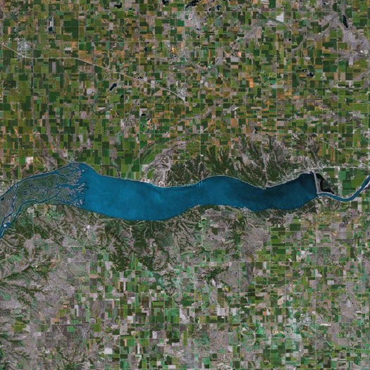
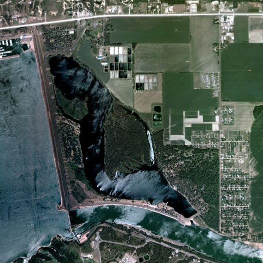
[Lewis and Clark Lake (top) and Gavins Point Dam (above); note that something of the meandering, shallow historical character of the Missouri is visible at the western end of the lake.]
I’ve said elsewhere that I think the Army Corps is an exceptionally peculiar organization, probably the country’s most radically avant-garde landscape practice, but rarely recognized for that, as it is the scale, agency, and organizational intricacy of the Corps’ work, not its formal properties, which render it so radical. A project like Hargreaves’ Guadeloupe River Park (rightly) receives attention for reconsidering the “paradigms of modern flood control” — but the Corps both constructed those paradigms and is currently deconstructing them, at the scale of not a single urban park, but the entire Missouri River Basin. Who else is doing organization work on this kind of scale? And what is the Spring Pulse, if not an infrastructural hack?
[Sources for this post include “Big Dam Era”, an Army Corps publication on the history of Missouri River infrastructures; “Sharing the Challenge”, a report by the “Interagency Floodplain Management Review Committee” recommending reactions to the Missouri and upper Mississippi floods in 1993; and materials from the Missouri River Recovery Program. Quotes not specifically attributed to other sources are taken from these publications. Another thing that is worth mentioning: I haven’t gone into them, but there are a host of issues related to the rights of Native populations in the basin, both historical — Native populations were displaced during the construction of the main stem dams — and contemporary, particularly concerning water rights. Finally, all satellite imagery via Google Maps, unless otherwise noted.]


[…] six dams and six reservoirs (m.ammoth.us) […]
[…] Peck Dam's borrow pits; photographer unknown. (Fort Peck, you will recall, was the first of the six major dams on the Missouri to be built.) The dredgers, pontoon boats, and booster barges used in the pumping of fill […]
[…] why the Army Corps is — despite the bureaucratic language it cloaks its practice in — such a radical landscape organization.) A bit more of this sort of experimentation with fluid and granular dynamics — and a bit […]
[…] of the posts are excellent and thought-provoking but I wanted to respond to two in particular: six dams and six reservoirs and dredging fort […]
[…] wanted to respond to two of mammoth‘s posts in the floods series, six dams and six reservoirs and dredging fort peck — chiefly, because they allow me an opportunity to refer to a […]