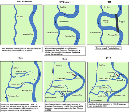
[Image compiled from Army Corps of Engineers diagrams via Wikimedia.]
Quoting further from McPhee’s “Atchafalaya”:
“…In the Red River, [Shreve] undertook to disassemble a “raft”—uprooted trees by the tens of thousands that were stopping navigation for a hundred and sixty miles. Shreve cleared eighty miles in one year. Meanwhile, at 31 degrees north latitude (about halfway between Vicksburg and Baton Rouge) he made a bold move on the Mississippi. In the sinusoidal path of the river, any meander tended to grow until its loop was so large it would cut itself off. At 31 degrees north latitude was a westbending loop that was eighteen miles around and had so nearly doubled back upon itself that Shreve decided to help it out. He adapted one of his snag boats as a dredge, and after two weeks of digging across the narrow neck he had a good swift current flowing. The Mississippi quickly took over. The width of Shreve’s new channel doubled in two days. A few days more and it had become the main channel of the river.
The great loop at 31 degrees north happened to be where the Red-Atchafalaya conjoined the Mississippi, like a pair of parentheses back to back. Steamboats had had difficulty there in the colliding waters. Shreve’s purpose in cutting off the loop was to give the boats a smoother shorter way to go, and, as an incidental, to speed up the Mississippi, lowering, however slightly, its crests in flood. One effect of the cutoff was to increase the flow of water out of the Mississippi and into the Atchafalaya, advancing the date of ultimate capture. Where the flow departed from the Mississippi now, it followed an arm of the cutoff meander. This short body of water soon became known as Old River. In less than a fortnight, it had been removed as a segment of the main-stem Mississippi and restyled as a form of surgical drain.”

