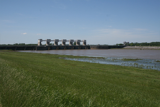
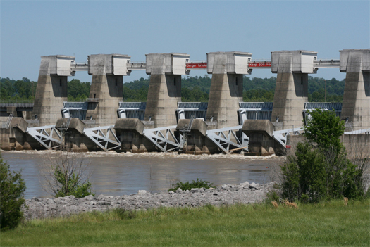
[The Auxiliary Structure at Old River Control; photographed by the Army Corps of Engineers, Team New Orleans.
Various circumstances have conspired to keep me from finishing the Floods series last week like I had hoped; there are still a few posts yet to come, and several of them will be part of this mini-series within a series, on the Atchafalaya Basin Project. That project could, I think, be fairly described as the single most significant component of the entire Mississippi River flood control complex. In truth, this is an interrupted series, which properly begins with a series of Atchafalaya-related posts from June: 1973, morganza floodway, and red river landing. I’m going to try to avoid repeating things already explained in those posts, so if it feels like you’re missing something, you might check there. If it still feels like you’re missing something, that’s probably just me writing poorly.]
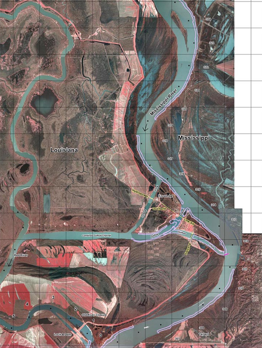
[Old River Control and Old River Lock, via the Army Corps of Engineers’ “Old River Hydraulic Sediment Response Model Study”.]
Old River is probably the most tense site of conflict between human engineering and the wild geomorphological tendencies of water in the United States, as it is here that the Army Corps fights the desire of the Mississippi River to switch its course into the Atchafalaya River and burn a faster, steeper path to the Gulf. Between 1890 and 1950, the Atchafalaya captured an ever increasing volume of water from the Mississippi — ten percent in 1890, twenty in 1920, thirty in 1950. This is because the Atchafalaya is roughly half the length of the Mississippi (measured from their point of convergence at Old River), and so it presents twice as steep a gradient. There is nothing unusual about the desire of the Mississippi to shift courses; since sea levels stabilized after the end of the last glacial period, it has done so roughly every thousand years, spraying sediment around the Gulf to form Southern Louisiana. In the time that the Mississippi has been on its present main course, though, it has been intensely urbanized — in 1950, New Orleans alone had over half a million citizens — and permitting it to shift has become unthinkable.
Consequently, the Army Corps of Engineers was ordered to freeze, for apparent perpetuity, the proportional flow of the Atchafalaya and the Mississippi, as they existed in 1950: thirty percent down the Atchafalaya, seventy percent down the Mississippi1.
Old River Control is the primary product of that order: one hydroelectric plant — ancillary to the primary purpose of the structure — and two sills, massive weirs for regulating the flow of the river. The higher sill is the Auxiliary Control Structure; it was completed in 1986, and is elevated above the normal level of the river, so that it serves as an additional release during extreme flood conditions. The Low Sill, the primary component of Old River Control, was finished in 1963: eleven gates, each forty-four feet wide, on a weir nearly six hundred feet long.
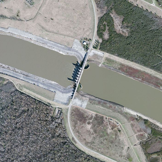
[The Auxiliary Control Structure.]
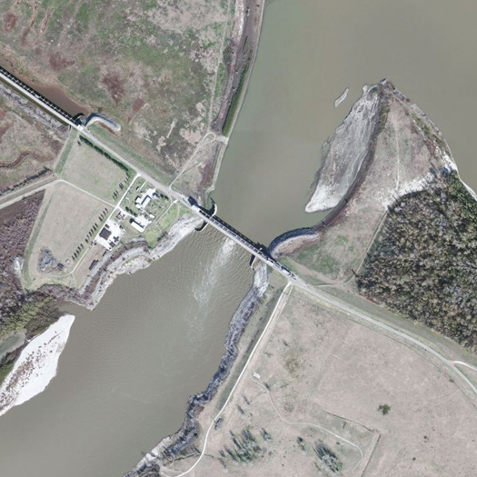
[The Low Sill.]
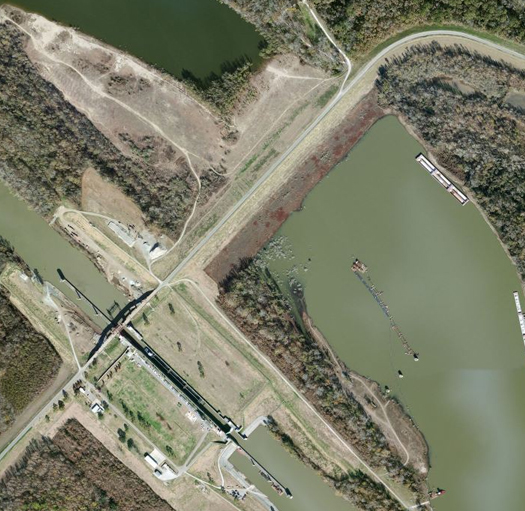
[Old River Lock, which permits navigation between the Mississippi, Red, and Atchafalaya Rivers, via Old River. These three images are via Bing Maps and to the same scale.]
The primary impetus for the construction of the Auxiliary Control Structure was an extraordinary event during the infrastructure-straining flood of 1973, which nearly destroyed the Low Sill — and almost set the Mississippi free down the course of the Atchafalaya. John McPhee’s classic narrative of the struggle between the Army Corps of Engineers and these two rivers, “Atchafalaya”, tells the story of that event. It may seem like I am quoting at extreme length — I suppose that I am — but the full piece is much, much longer, and well-worth reserving a few hours to read. At any rate, “Atchafalaya”:
“In mid-March [1973], when the volume began to approach that amount, curiosity got the best of Raphael G. Kazmann, author of a book called “Modern Hydrology” and professor of civil engineering at Louisiana State University. Kazmann got into his car, crossed the Mississippi on the high bridge at Baton Rouge, and made his way north to Old River. He parked, got out, and began to walk the structure. An extremely low percentage of its five hundred and sixty-six feet eradicated his curiosity. “That whole miserable structure was vibrating,” he recalled in 1986, adding that he had felt as if he were standing on a platform at a small rural train station when “a fully loaded freight goes through.” Kazmann opted not to wait for the caboose. “I thought, This thing weighs two hundred thousand tons. When two hundred thousand tons vibrates like this, this is no place for R. G. Kazmann. I got into my car, turned around, and got the hell out of there. I was just a professor—and, thank God, not responsible.”
…Nowhere in the Mississippi Valley were velocities greater than in this one place, where the waters made their hydraulic jump, plunging over what Kazmann describes as “concrete falls” into the regime of the Atchafalaya. The structure and its stilling basin had been configured to dissipate energy—but not nearly so much energy. The excess force was attacking the environment of the structure. A large eddy had formed. Unbeknownst to anyone, its swirling power was excavating sediments by the inflow apron of the structure. Even larger holes had formed under the apron itself. Unfortunately, the main force of the Mississippi was crashing against the south side of the inflow channel, producing unplanned turbulence. The control structure had been set up near the outside of a bend of the river, and closer to the Mississippi than many engineers thought wise.
On the outflow side—where the water fell to the level of the Atchafalaya—a hole had developed that was larger and deeper than a football stadium, and with much the same shape. It was hidden, of course, far beneath the chop of wild water. The Corps had long since been compelled to leave all eleven gates wide open, in order to reduce to the greatest extent possible the force that was shaking the structure, and so there was no alternative to aggravating the effects on the bed of the channel. In addition to the structure’s weight, what was holding it in place was a millipede of stilts—steel H-beams that reached down at various angles, as pilings, ninety feet through sands and silts, through clayey peats and organic mucks. There never was a question of anchoring such a fortress in rock. The shallowest rock was seven thousand feet straight down. In three places below the structure, sheet steel went into the substrate like fins; but the integrity of the structure depended essentially on the H-beams, and vehicular traffic continued to cross it en route to San Luis Rey.
Then, as now, LeRoy Dugas was the person whose hand controlled Old River Control—a thought that makes him smile. “We couldn’t afford to close any of the gates,” he remarked to me one day at Old River. “Too much water was passing through the structure. Water picked up riprap off the bottom in front, and rammed it through to the tail bed.” The riprap included derrick stones, and each stone weighed seven tons. On the level of the road deck, the vibrations increased. The operator of a moving crane let the crane move without him and waited for it at the end of the structure. Dugie continued, “You could get on the structure with your automobile and open the door and it would close the door.” The crisis recalled the magnitude of “the ’27 high water,” when Dugie was a baby. Up the valley somewhere, during the ’27 high water, was a railroad bridge with a train sitting on it loaded with coal. The train had been put there because its weight might help keep the bridge in place, but the bridge, vibrating in the floodwater, produced so much friction that the coal in the gondolas caught fire. Soon the bridge, the train, and the glowing coal fell into the water.
One April evening in 1973—at the height of the flood—a fisherman walked onto the structure. There is, after all, order in the universe, and some things take precedence over impending disasters. On the inflow side, facing the Mississippi, the structure was bracketed by a pair of guide walls that reached out like curving arms to bring in the water. Close by the guide wall at the south end was the swirling eddy, which by now had become a whirlpool. There was other motion as well—or so it seemed. The fisherman went to find Dugas, in his command post at the north end of the structure, and told him the guide wall had moved. Dugie told the fisherman he was seeing things. The fisherman nodded affirmatively.
When Dugie himself went to look at the guide wall, he looked at it for the last time. “It was slipping into the river, into the inflow channel.” Slowly it dipped, sank, broke. Its foundations were gone. There was nothing below it but water. Professor Kazmann likes to say that this was when the Corps became “scared green.” Whatever the engineers may have felt, as soon as the water began to recede they set about learning the dimensions of the damage. The structure was obviously undermined, but how much so, and where? What was solid, what was not? What was directly below the gates and the roadway? With a diamond drill, in a central position, they bored the first of many holes in the structure. When they had penetrated to basal levels, they lowered a television camera into the hole. They saw fish.
…
The damage at Old River was increased but not initiated by the 1973 flood. The invasive scouring of the channel bed and the undermining of the control structure may actually have begun in 1963, as soon as the structure opened. In years that followed, loose barges now and again slammed against the gates, stuck there for months, blocked the flow, enhanced the hydraulic jump, and no doubt contributed to the scouring. Scour holes formed on both sides of the control structure, and expanded steadily. If they had met in 1973, they might have brought the structure down.
After the waters quieted and the concrete had been penetrated by exploratory diamond drills, Old River Control at once became, and has since remained, the civil-works project of highest national priority for the U.S. Army Corps of Engineers. Through the surface of Louisiana 15, the road that traverses the structure, more holes were drilled, with diameters the size of dinner plates, and grout was inserted in the cavities below, like fillings in a row of molars. The grout was cement and bentonite. The drilling and filling went on for months. There was no alternative to leaving gates open and giving up control. Stress on the structure was lowest with the gates open. Turbulence in the channel was commensurately higher. The greater turbulence allowed tho water on the Atchafalaya side to dig deeper and increase its advantage over the Mississippi side. As the Corps has reported, “The percentage of Mississippi River flow being diverted through the structure in the absence of control was steadily increasing.” That could not be helped.
After three and a half years, control was to some extent restored, but the extent was limited. In the words of the Corps, “The partial foundation undermining which occurred in 1973 inflicted permanent damage to the foundation of the low sill control structure. Emergency foundation repair, in the form of rock riprap and cement grout, was performed to safeguard the structure from a potential total failure. The foundation under approximately fifty per cent of the structure was drastically and irrevocably changed.” The structure had been built to function with a maximum difference of thirty-seven feet between the Mississippi and Atchafalaya sides. That maximum now had to be lowered to twenty-two feet—a diminution that brought forth the humor in the phrase “Old River Control.” Robert Fairless, a New Orleans District engineer who has long been a part of the Old River story, once told me that “things were touch and go for some months in 1973” and the situation was precarious still. “At a head greater than twenty-two feet, there’s danger of losing the whole thing,” he said. “If loose barges were to be pulled into the front of the structure where they would block the flow, the head would build up, and there’d be nothing we could do about it.”
Read the full piece in the New Yorker’s archive; it can also be found in one of McPhee’s books, The Control of Nature.


[…] of Engineers' "Old River Hydraulic Sediment Response Model Study", in which a physical model of Old River Control was used to test the distribution of sediment deposition under various flow conditions in the Low […]
[…] Old River Control sits at the northern end of the Atchafalaya River; at the southern end, in the brackish waters of Atchafalaya Bay, a similarly massive wall of concrete protects a port: the Morgan City Floodwall. […]
[…] design scenarios for a hypothetical shift of the Mississippi River from its current course to the course it “naturally” desires to take through the Atchafalaya Basin. (This was particularly enjoyable given that I’d accidentally […]