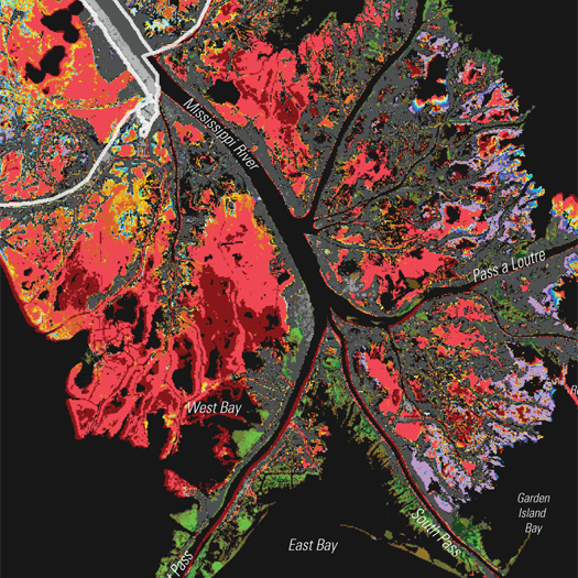
[The fluctuating terrain of the lower Mississippi River Delta, from the USGS’s map of “land area change in coastal Louisiana from 1932 to 2010”. Loss is in red; accumulation is in green. The map is seen via Free Association Design, where you can see the map in more detail, including the rapidly accreting area of the Wax Lake Delta we previously mentioned.]
There is widespread agreement that the rapid loss of coastal wetlands is one of the most negative consequences of the channelization of the Mississippi River for flood control and commercial navigation. (After Richard Campanella, we can call this the dysfunction of the land-making machine.) The Mississippi no longer carries as much sediment as it once did (increased erosion due to agriculture, deforestation, and urbanization in the Mississippi River Basin are collectively more than offset by the siltation produced by dams), and much of what sediment it does carry is now shot so rapidly out the Birdfoot into the Gulf that it is unable to coalesce into new land. Overbank flooding, which once carried freshwater and sediment into the wetlands adjacent to the course of the river, no longer occurs. Consequently, the delta, which once grew so rapidly, has been shrinking for most of the 20th century and all of the 21st — somewhere around a football field of land erodes every forty-five minutes1.
Just as the Army Corps has a stated interest in preserving a specific moment in the hydrological distribution of the Mississippi River through the Old River Control Structure, it also has a significant — though less fully realized — interest in preserving a specific historical moment in the evolution of the soggy land of the delta, as the delta is valuable both ecologically (roughly a third of the nation’s coastal wetlands are in Louisiana) and economically (fish and wildlife harvests, protection from storm surge, sites for both infrastructure and buildings). Hurricane Katrina, of course, both highlighted the increased vulnerability of human settlements to the sea as the wetlands that once buffered those settlements are lost, and accelerated that loss by washing sandbars and barrier islands away.
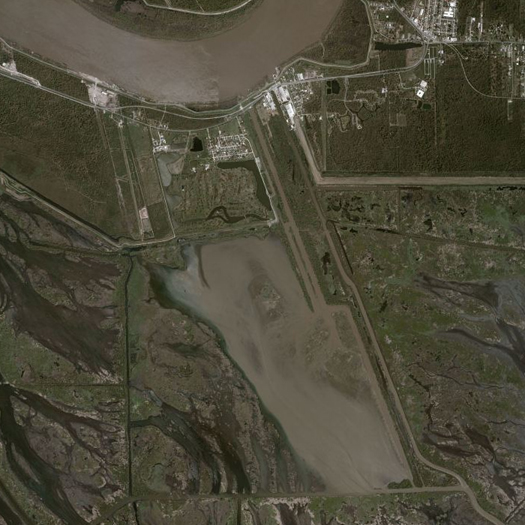
[Caernarvon Freshwater Diversion]
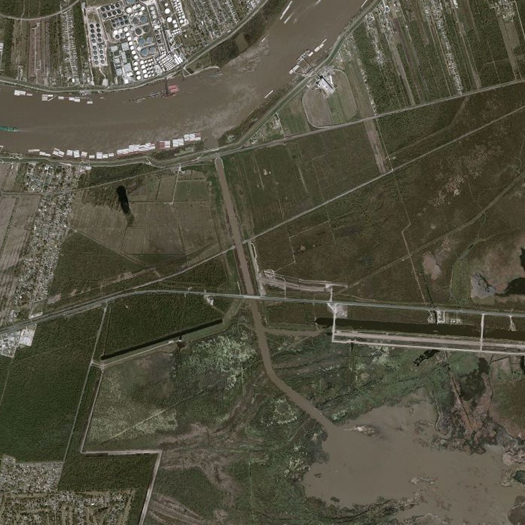
[Davis Pond Freshwater Diversion]
The first effort that the Army Corps made to slow the loss of the delta was the planning and construction of three “freshwater diversion structures”: Caernavon, Davis Pond, and Bonnet Carre. Caernavon (1991) is downstream from New Orleans, Davis Pond (2002) is upstream, and, when it is built, Bonnet Carre (planned) will be upstream (at the site of the Bonnet Carre Spillway). These structures do not directly restore the function of the land-making machine — they do not carry sediment — but they do funnel freshwater into the marshes, “re-establishing favorable salinity conditions” for both wildlife and the brackish marsh vegetation which helps establish and maintain deltaic land. In halting and reversing the process of salt water intrusion at Caernavon (which has been exacerbated by the canals cut into the delta in the pursuit of resource extraction), for instance, the Corps has achieved a net annual increase of 15 acres.
This was a substantial achievement; but it is hardly sufficient to restore the function of the land-making machine. Hurricane Katrina, for example, destroyed 26,176 acres of wetland in the Caernavon project area — it would take nearly two millennia for the freshwater diversion structure to restore those lost acres.
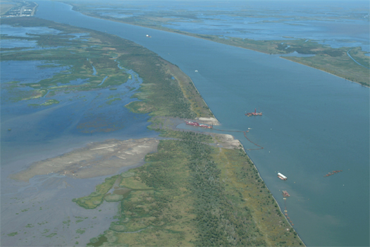
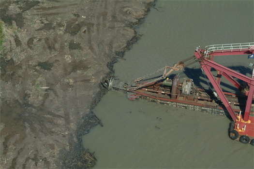
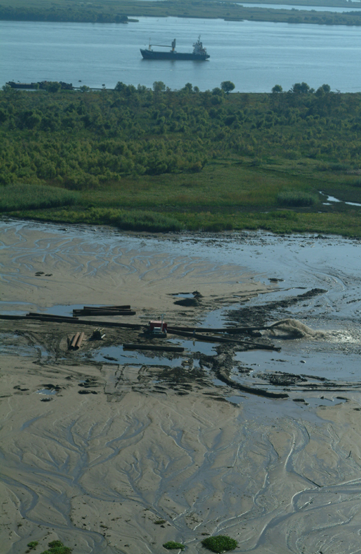
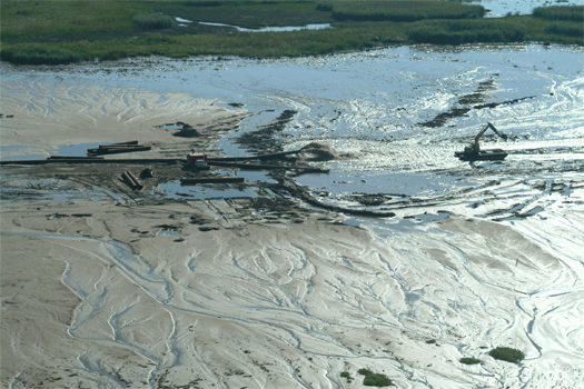
[Army Corps of Engineers photographs of the construction of the West Bay Sediment Diversion, a project in the Mississippi River Delta near Head of Passes; while the Sediment Diversion itself is intended to build land by capturing water and sediment from the main stem of the Mississippi, the process of constructing the channel for the Diversion required dredging, and no good land builder ever misses an opportunity to use free dredge. The photos above, then, show how the dredge generated by the digging of the Diversion channel was used to construct more than 200 acres of new wetlands. (It’s not worth explaining the details here, but it is worth noting that the West Bay Sediment Diversion is scheduled to be closed, because it has interfered with shipping without producing as significant a clear benefit as had been expected. The politics of land-making are difficult.)]
In response to this scalar mismatch, the Corps is utilizing two primary additional tactics: dredging and directly placing sediment in key locations (as in the Bayou Dupont Sediment Delivery System, the Barataria Basin Land Bridge, or even the construction process of the West Bay Sediment Diversion shown above), and testing a new kind of diversion structure, which will divert ten times as much water as the original diversion structures2. A fascinating article by T. Edward Nickens at Popular Mechanics describes the design and engineering of this new diversion structure, called the Myrtle Grove Water and Sediment Diversion Structure; the design process relied on both physical modeling — a “24 x 28–foot small-scale physical model [that] replicates the river’s final 84 miles through 3526 square miles of wetlands and estuary” — and advanced hydrological and sedimentary simulations run by the computers of the Waterways Experiment Station. Here, Nickens describes the operation of the physical model and the process of gathering experimental data in the river itself:
When [LSU engineering professor Clinton] Willson turns up the river, particles begin to vibrate, then roll along the bottom. Other particles race downstream in inky blue plumes and screw-like helixes. Choreographing this dance is critical to designing systems that capture the maximum amount of suspended clays, sands and silts. At what flow rate do sand grains experience “liftoff” from the river bottom? When does saltation—the bouncing, leaping movement of individual grains that bump into one another to create a cascade of sediment flow—begin? “We’re dealing with a multitude of intricacies,” [project geologist Brian] Vosburg says.
He could be referring to the complex model, or to the complicated process of getting dirt out of a real river. Capturing sediment isn’t as simple as unplugging a levee. Only at river-flow levels above approximately 600,000 cfs, a volume that can occur any time of year, do the heavier, coarser sands that are best for building new land rise to the upper strata of the river, where they can be siphoned off through the diversion and channeled to the marsh.
To calculate how much sediment might be available at Myrtle Grove, engineers deploy an ingenious array of monitoring technologies. Ship-based multibeam bathymetry paints a picture of gigantic underwater dunes rippling along the riverbed. Side-scan sonar maps the relative hardness of the bottom; a device using LISST (laser in-situ scattering and transmissometry) technology measures sediment volume. An Acoustic Doppler Current Profiler produces detailed imagery of water velocity, direction and magnitude in cross sections of the riverbed and reveals patterns of sediments. “We are literally and technically listening to the river and letting it tell us where the resources are,” Vosburg says.
Restoring the land-making machine, in other words, requires an experimental landscape architecture.

[The “Barataria Basin Finite Element Grid”, from morphological studies of the effects of the proposed Myrtle Grove diversion. (The small bulge in the upper north-west corner of the image is Davis Pond.) Image by Moffat & Nichol and the Office of Coastal Protection and Restoration.]
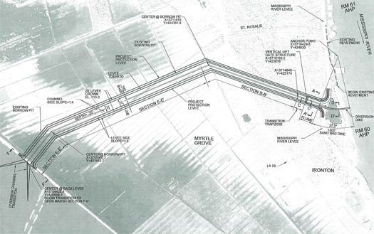
[One of the potential configurations of the Myrtle Grove diversion, from an Army Corps of Engineers study.]
Whether this landscape architecture will involve landscape architects, of course, is an entirely separate question. Mammoth would argue that it can and should, of course, that these kinds of projects would benefit from being guided by both the specialized expertise of the engineer and the generalist sensibilities of the landscape architect, as they require both a rigorous understanding of the forces being invoked and they trace a transect across a hopelessly broad swath of issues, from competing land (and water) use claims to conflicting visions of nature; but for this to happen, there will need to be an internal shift in both how landscape architects understand the discipline, and an external shift in how their skills are utilized.


The apparent flexibility available by design such as this
http://www.popularmechanics.com/cm/popularmechanics/images/saving_louisiana_04_0111-de-26377016.jpg
is intriguing. Not just a levee but a adjustable levee..
Although one wonders if the sort of flexibility they are imagining is really an example of soft design, when compared to the inherently flexible systems of natural land aggregation?
[…] home // hide asides // links // index.archive // contact us // about « restoring the land-making machine […]