
[American Falls de-watered, via Flickr user rbglasson]
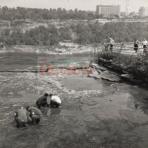
For six months in the summer and fall of 1969, Niagara’s American Falls were “de-watered”, as the Army Corps of Engineers conducted a geological survey of the falls’ rock face, concerned that it was becoming destabilized by erosion. During the interim study period, the dried riverbed and shale was drip-irrigated, like some mineral garden in a tender establishment period, by long pipes stretched across the gap, to maintain a sufficient and stabilizing level of moisture. For a portion of that period, while workers cleaned the former river-bottom of unwanted mosses and drilled test-cores in search of instabilities, a temporary walkway was installed a mere twenty feet from the edge of the dry falls, and tourists were able to explore this otherwise inaccessible and hostile landscape.
A riverbed, in other words, became an ephemeral public park, though as by-product of a potentially colossal geo-re-engineering project1. The authorities even installed temporary interpretative signage explaining the Fall’s geology to inquisitive visitors. Which, of course, raises the possibility that other ephemeral parks might be constructed, perhaps not as by-product, but solely to provide access to new terrains. Without consideration of the practicalities: lower the Hudson for a month, and hold a rock-climbing festival along new cliffs, the competitors scrambling up Hartland Schist in the mist of spray-emitters stabilizing the rocky banks. Let loose the dammed power-lakes of the Tennessee Valley Authority, and hold Bonnaroo on the muddy bottom of Harrison Bay, temporarily un-flooded.
Or, less ephemerally, when the Chicago River is re-reversed, will the city partition and drain it at the canal locks, and sell off the resultant land-rights?
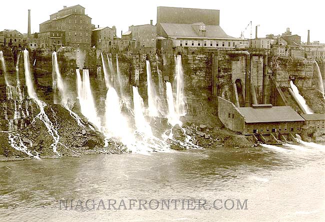
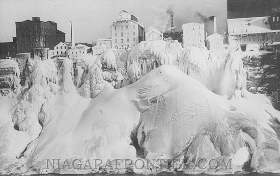
Further fascinating history of Niagara Falls: in the nineteenth century, the “tailraces” — essentially, industrially-scaled discharge pipes which created artificial water falls in the gorge — of the Mill District were nearly as famous a tourist attraction as the natural falls. From the photographs (also: in winter), it is easy to see why; also, at Places, Barbara Penner reviews Ginger Strand’s “Inventing Niagara”; finally, Strand’s own Niagara Toxic Tour.

Wasn’t the goal of the Army Corps’s stabilization program fundamentally anti-ephemeral? It’s certainly ironic to create one temporary space in the process of preventing another.
Hmm, the image didn’t come through: Try this.
Indeed it was and, as you’ve pointed out, quite ironically so.
I find it really fascinating that they got so deep into the process of halting geology in order to preserve a landscape for aesthetic pleasure, even if they eventually backed off.
You think they l are going to re-reverse the course?
I mean it does seem like the Great Lake states are more serious than i can ever remember.
Saw something the other day (not sure exactly where) that indicated they were considering it pretty seriously.
Whatever the politics of reversing the river’s un-natural course, I’m more than ready to talk about new housing complexes hanging below and beside the Loop like Zenetos’s Hanging Hotel, or the menagerie of cable cars, escalators, and elevators that the residents of this new district will use for their daily vertical commutes.
[…] In 1969, Niagra Falls were turned off. […]
[…] Mammoth: For six months in the winter and fall of 1969, Niagara’s American Falls were “de-watered”, […]
[…] via Mammoth […]
[…] En el año 1969, el cuerpo de ingenieros de la Armada estadounidense llevó a cabo un hecho sin precedentes, lograron detener las cataratas del Niágara. Lo hicieron para limpiar el área y para comprobar la integridad estructural del salto del agua. Podéis ver algunas fotos de aquel evento en la galería de Rbglasson en Flickr. Según explican en el bog M.ammoth: […]
[…] American Falls de-watered Documentary Nálepky: falls (1), geology (1), water (13) WoodenSnail […]
[…] 1969, the US Army Corps of Engineers “de-watered” the American Falls portion of Niagara Falls to assess the effects of erosion on the Falls’ rock face, and […]
Funny to just be coming across this now, via someone’s twittering of an old io9 link. Only wanted to say this: “Of course it’s becoming destabilized by erosion, it’s fucking Niagra Falls!”
[…] 1969 stoppten Ingenieure der US Army Corps einen der Niagarafälle um das Gestein unter den Fällen zu untersuchen. Für sechs Monate konnten Touristen sogar auf dem trockenen Gestein rumlatschen. Es wurden sogar Schilder augestellt, die die geologischen Beschaffenheiten des Flussbettes erklärten. Obwohl man feststellte, dass das Gestein relativ instabil ist, entschied man sich dagegen die Felsen zu sichern. Die Kosten hätten in keiner Relation zum Ergebnis gestanden. […]
[…] las cataratas del Niágara se secaron, una historia muy interesante que […]
[…] via Mammoth […]
[…] Mammoth, explains the reasoning and details more clearly here. For six months in the winter and fall of 1969, Niagara’s American Falls were “de-watered”, as the Army Corps of Engineers conducted a geological survey of the falls’ rock face, concerned that it was becoming destabilized by erosion. During the interim study period, the dried riverbed and shale was drip-irrigated, like some mineral garden in a tender establishment period, by long pipes stretched across the gap, to maintain a sufficient and stabilizing level of moisture. For a portion of that period, while workers cleaned the former river-bottom of unwanted mosses and drilled test-cores in search of instabilities, a temporary walkway was installed a mere twenty feet from the edge of the dry falls, and tourists were able to explore this otherwise inaccessible and hostile landscape. […]
Mammoth isn’t right, the American Falls was dewatered in the summer and fall of 1969 (may-Sept.) There was no drip-irrigation!, there were 30 1″ water pipes at the base of the Falls to soak the shale 24-7, spaced approx. 25ft. apart and fed by the waterlines in the above picture.
The workers were removing silt and moss from the top of the falls for aerial pics. to determine where the cracks were. Dyes were placed in some of the cracks 200ft’ back from the face. And NO we didn’t clean the bottom of the falls…I should know, I was there!
Tom,
Thanks for the comment — fantastic to hear from someone who was there.
I transposed the dates, and have corrected them.
The pipes you describe are what I referred to (with some literary license) as drip irrigation; I am aware that they were not literally drip irrigation.
The post does not state that the bottom of the falls was cleaned, but, rather the river bottom, which is what was exposed at the top of the falls when the water was held back. (That is, there is river bottom at both top and bottom of the falls.)
rholmes, Sorry to snap, but I know there is alot of mis-information out there. I am presently working on a project to put out to the public some pics of the de-watered Niagara Falls. We also took rock core samples from bottom drilling horizonally that showed a huge crack at a 45 degree angle. One day the whole face of the Falls will come off.(Dye tests proved this)
What most people didn’t see during the time the falls was off, was that there “is” a natural rock formation of an Indian Head at the farthest point out, near the top. The front-half of a complete face was seen and also photographed by Ripleys Believe it or Not!! Thanks Tom….Again sorry for snapping
Tom,
No offense taken — would love to hear about it when your project goes public. Like I said, genuinely fantastic to hear from someone who was there at this rather unique moment.
[…] 1969, inginerii armatei Statelor Unite au oprit apa cascadei pentru a o cerceta, a curăța zona și întreprinde diverse lucrări. […]