The following post, which is more a catalog of related items than a singular argument, has been written to engage the “Glacier/Island/Storm” studio BLDGBLOG is currently teaching at Columbia GSAPP, as a part of a timed release of material into the blogosphere coordinated across a bank of architecture, design, and technology blogs; you can find a description of the studio here and a list of the eight blogs releasing timed material here.
A possibility: glaciers, islands, and storms are as much events as they are objects; as events, they are primarily composed of processes of accretion and erosion. A storm is a relatively brief event, a glacier is a very long event, and an island is an even longer event; yet all are, on a geological time scale, ephemeral. In fact, it might be reasonable to understand these events as geology, with all the inherent instability (on a geological time scale, no construct is stable), flux, and unpredictability that is implied by the study of geological events.
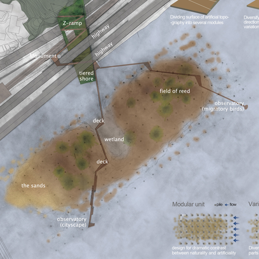
Three corresponding architectural proposals are inserted between the processes and events described: a landfill park on Staten Island, an artificial ecology inserted into a salt mine in the Galapagos Islands, and a field guide to the landscape of Gateway National Recreation Area. The three illustrate, respectively, what the value of accepting an unstable design process when designing at a geologic scale might be, how processes of accretion and erosion can be incorporated into the design of a building, and how existing processes on a site can be harnessed to make invisible qualities and landscapes legible.
A. METAMORPHIC GLACIERS
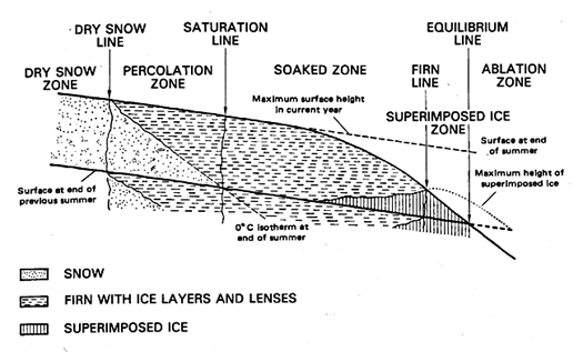
A glacier is a very quick rock:
Glaciers form in any area in which a year-to-year surplus of snow occurs. Under such conditions, successive layers of snow are slowly compacted until the loose snowflakes form a monomineralogic (frozen H2O) sedimentary deposit that gradually becomes more and more dense with increasing depth and age. When a density of 830 to 910 kg/m3 is reached, formation of ice occurs (Paterson, 1981). As the effect of gravity slowly deforms this mass of ice, a glacier is formed. A glacier therefore represents an unusual type of metamorphic rock, being the result of deformation of what was originally a sedimentary rock… Glaciers are a peculiar type of landform because they can in turn modify the existing (preglacial) landscape, producing both erosional and depositional landforms.
B. JOKULHLAUPS
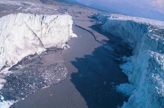
There are two primary kinds of landform produced by the activities of glaciers, which correspond neatly with processes of accretion and erosion: depositional glacial landforms and erosional glacial landforms; a third, periglacial landforms such as thermokarst and ice-wedge polygons, occur in close proximity to glaciers due to the cold climate and the action of ground ice, but not as the direct result of glacial processes.
Depositional landforms, which include moraines (terminal, recessional, interlobate, and ground), esker, drumlins, delta and delta kame, shoreline, outwash plains, and kettles, are perhaps the more familiar of the two kinds, but the two always occur in tandem, as the material for deposition is acquired through the production of erosional landforms; one might be tempted to say that glaciers do not actually produce any new landforms, but only rearrange existing landforms. The primary mechanism for the formation of glacial landforms is the “action of moving ice and… the deposition of till beneath and adjacent to the glacier” (the most familiar glacial landscapes, such fjords and the aforementioned moraines are produced through this mechanism), but glaciers also produce accretions through other mechanisms, including the discharge of sediment in meltwater and the periglacial formation of “rock glaciers” (which are composed of both ice and rock fragments) — and erosions through an equal variety of secondary mechanisms, the most of intense of which is the Jokulhlaup.
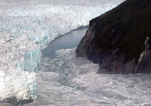
Jokulhlaup, or glacial outburst floods (jokull is Icelandic for glacier and hlaup floodburst), occur when a glacier-dammed lake rapidly releases water — accumulated through rainfall, runoff, snowfall, snow melt, and melt from the glacier itself — in intense and often periodic bursts. Some jokulhlaups occur with some measure of regularity due to the seasonal buildup of water pressure in the dammed lake, while others are triggered by avalanches, earthquakes, volcanoes, or even iceberg formation. NASA’s Geomorphology from Space describes the jokulhlaup as “perhaps the most remarkable fluvial processes on the planet Earth”, as the intensity of the most massive of these flooding events is “the greatest that can be documented in the geologic record of river activity”.
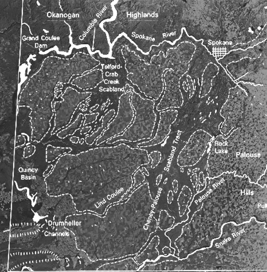
The singular event that requires such superlative description occurred near the end of the last glacial period, approximately thirteen thousand years ago. A massive ice sheet stopped up the Columbia River in what is now Idaho, producing a glacially-impounded lake geologists refer to as Glacial Lake Missoula. At its peak, the lake was two thousand feet deep and held over five hundred cubic miles of water, more than the combined volume of contemporary Lake Erie and Lake Ontario.
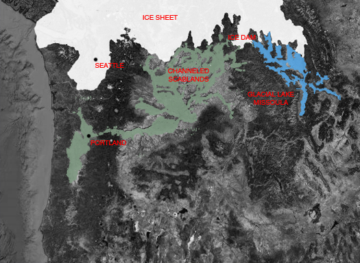
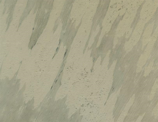
When the volume of water eventually grew too great for the glacial dam to bear, Glacial Lake Missoula exploded down the riverbed, in a rushing wall of water and ice hundreds of meters high, with a peak rate of flow ten times the combined flow of all the rivers in the world. This erosive torrent produced outlandish geologic scars in the Columbia River basin, including the distinctive “channeled scabland” pictured above:
…oversized river channels and colossal riverbed potholes that present-day streams could not have cut; ripple marks big enough to be levees; gigantic strips of land where all soil was stripped to bedrock and bedrock itself plucked out in house-sized chunks. Downstream were widespread layers of sand and clay many meters thick without soil horizons—the flood was so great that the whole Columbia River Gorge became a bottleneck, and the backed-up flow had to drop its sediment load.
C. DYNAMIC COALITION
Dynamic Coalition, one of the six finalist proposals selected in the Fresh Kills competition, was developed by Mathur/da Cunha and Tom Leader Studio. In Praxis 4, they describe the two qualities of Fresh Kills which inspired their design, “its shifting nature” and “its material diversity”, leading to a proposal which is, unlike even Field Operation’s inspiring plan, not a master plan at all:
Our role as designers is to reveal the richly layered landscape of Fresh Kills and set in motion the material engagement of the five terrains we identify. Each leads to an emphasis on certain types of interventions and programs as opposed to others. Yet nothing that we are proposing precludes the evolution of these ideas by interests that we as designers are either unaware of or cannot anticipate at the this time given the decades long development time line of this shifting and diverse landscape.
Stewarding the five terrains requires the agility and lightness of a dynamic coalition rather than the regulatory authority of a master plan. The way we see it, each terrain will attract a partnership field that will give it a direction and a voice. We visualize partnership fields comprising groups, institutions, associations, and individuals operating at various scales. These fields act as clearinghouses to introduce and coordinate potential partners, apply for funds from public and private sources, provide long-term continuity and project management, and serve as a source for continuous outreach to ever-wider publics. The Office of the Borough President of Staten Island could lead in the establishment of the these partnership fields and facilitate their coalition particularly since the trajectories of each are bound to intersect.
Ultimately we can only demonstrate the dynamics of the terrain and not exhaust its possibilities. What matters more than our projections are the starting points of our investigation and that they engage the public, not as end users or decision-makers but as initiators of other possibilities…
Dynamic Coalition is intentionally situated in terrain which is unstable, not merely in physical and ecological dimensions, but also institutionally, as it proposes not an end-state for the Fresh Kills landscape, but a design process that is “experimental and engaging, learning and evolving, constructive and flexible.”1
This instability, though, extends also to the proposed landscape interventions, which are grouped under the headings “event surface”, “experimental field”, “material datum”, “depositional edge”, and “tectonic zone”. Those interventions are inscribed upon terrains of “diverse debris depositions”, or a series of accreted layers, which are, in reverse order of deposition but in parallel order to the design interventions, debris from the twin towers of the World Trade Center; city garbage which comprises the landfill; sedimentary marsh detritus; glacial till dropped by the retreating Laurentide ice sheet ten thousand years ago; and crushed rocks from the breakup of the supercontinent Pangea three hundred million years ago.
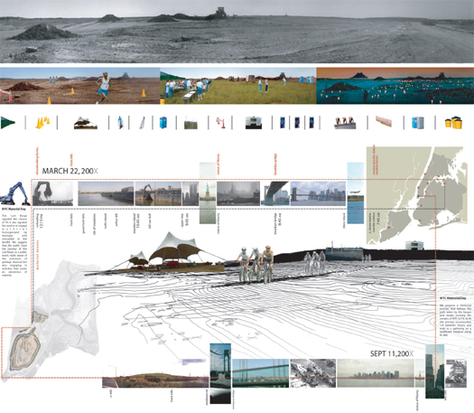
As “event surface”, Dynamic Coalition proposes two initial temporary appropriations of the Fresh Kills site. The first, “NYC Material Day”, serves as a notable extension of the team’s desire to acknowledge that, while Fresh Kills may no longer receive material waste, this is not at all due to a change in the volume of waste produced by New York City, and so on March 22nd of each year the public would have the opportunity to “trace the journey of the Last Barge [of waste to arrive at Fresh Kills] and engage in activities that create an awareness of materials”. The second, “WTC Memorial Day”, is composed of a memorial journey tracing the path of the barges and trucks which carried the debris to Fresh Kills and ending in a wildflower meadow on the debris site. These events, though, are not intended to describe the full future calendar of Fresh Kills, but to be the first two in “a constellation of events” “inscribing the surface of Fresh Kills with a growing richness of meaning”.
The second intervention, or “experimental field”, proposes the identification of a series of corridors, margins, lines, islands, and stations within the boundaries of the Fresh Kills site which can be used by artists and scientists as laboratories for “a radically expanded program of research and experiment”, inviting the public into meaningful participation with the processes shaping Fresh Kills.
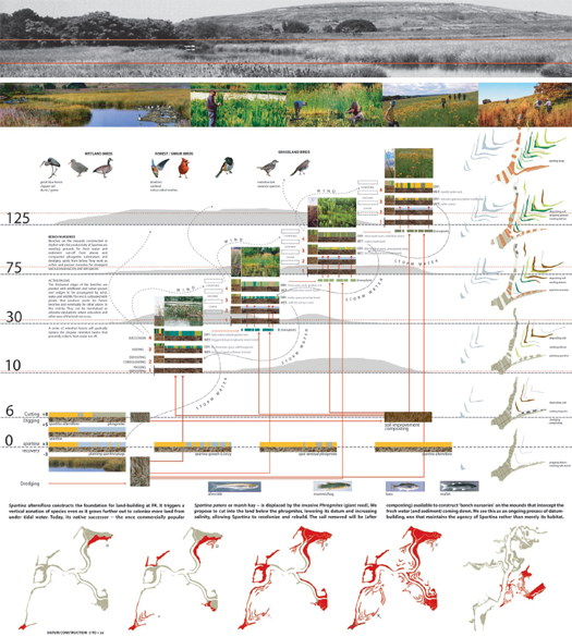
The “material datum” are constructed through a slow program of cut and fill, exploiting the differences in the growth habits and salinity tolerances of the invasive Giant Reed (Phragmites) and the native Marsh Hay (Spartina patens), as well as the naturalized Smooth Cordgrass (Spartina alterniflora). Cutting into the soft soils beneath the Phragmites lowers its bathymetric datum and increases local salinity, “allowing Spartina to recolonize and rebuild”. The dredged soil can then be composted and used to construct topographic nursery benches which “intercept fresh water (and sediment) runoff”, “work[ing] as… nurseries for emergent and successional, dry and wet species”. As the benches spread, they cultivate additional seed for future benches, gradually producing a self-sustaining system of “arboreta equivalents” which “progressively replace the current engineered detention basins” at Fresh Kills, which have the twin disadvantages of preventing stormwater from nourishing flora and preventing flora from cleansing that stormwater.
At its edges, Dynamic Coalition’s Fresh Kills would becomes fragmented and porous, interacting with the surrounding neighborhoods through what the proposal describes as “depositional edges”, “thresholds” which “are sites that like the land beneath a retreating glacier become richly layered with material depositions… [forging] new landscapes”. Neighborhood cross streets might extend into the park, allowing the construction of housing on “piers” of fill within the park’s now porous boundaries, while marshes extend reciprocally into the neighborhood, creating a hybrid zone of transition between housing and park. The forested berm which screens Fresh Kills from the Staten Island Mall could be cut, opening gaps which can be developed as “marketing areas for the recycled and processed materials generated on Fresh Kills”, while the removed soil and trees is used to create a reconfigured landscape linking the Mall to the park, blending commercialism and recycling.
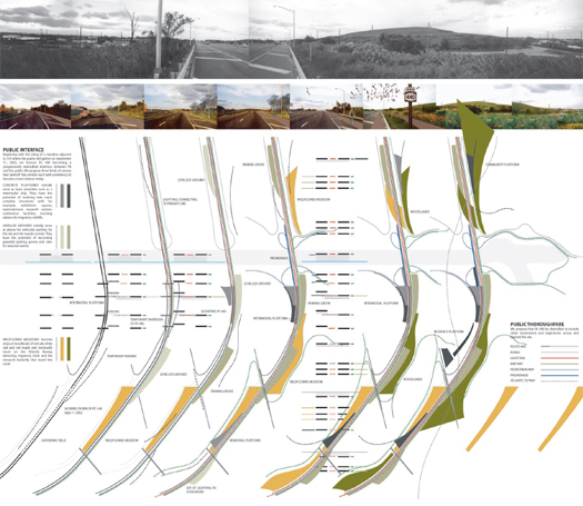
The final intervention, the “tectonic zone”, describes the evolution of the West Shore Expressway, which bisects Fresh Kills, into an “intensified” and “diversified” zone of activity, through the augmentation of the surrounding landscape (wildflower meadows, gathering fields, a memorial platform, woodlands), the extension of light rail to New Jersey and Brooklyn, bicycle paths, and a pedestrian promenade. The site is opened to potential future development — Dynamic Coalition suggests that high tech or financial firms might be interested in the site — furthering the bleed between city and park.
Cumulatively, these five “seeds” aim to engender a set of processes which will eventually produce a dynamic park, ecologically functional yet fully embedded within the political and social landscape of the metropolitan region. Each can also be read in terms of accretion and erosion, whether that seed is intended to spark the metaphorical accretion of events on the annual calendar of Fresh Kills, as in the case of the “event surface”, or the literal and physical acceleration of accretion and erosion in the proposed cut-and-fill operations at the water’s edge.
Returning briefly to the original instability I noted, that of the design process itself, it remains important to note that these five interventions are lent a much greater strength by that description as “seeds”, which implies the willingness of the designers to recognize the complexity of the systems that they are grappling with and the scale of the landscape itself, vast in both physical and temporal dimensions (much like glacier, island, and storm). In the project narrative, the team describes how that conscious limitation might produce a more successful planning process, multiplying the effectiveness of the project within the region:
Each seed takes Fresh Kills beyond its property lines, making it a transformative agent of a region. These extensions range from events that build community at various geographical scales to physical infrastructure that alleviate problems; from research and education programs that carry Fresh Kills to laboratories and classrooms in distant lands to the daily use of the site by local inhabitants.
Conventional means of defining and engaging community need to be reconsidered for Fresh Kills. To hold a series of public workshops, while not useless, does lead to the convenient notion that public “input” has been achieved and the “plan” can proceed. Such a momentary forum involving “issue sorting” and brainstorming” lead by a facilitator with note cards and magic markers finally reduces each person to a spot on a list of public comments.
In the same way that this project tries to engage the dynamics of the site, it also proposes various means by which groups as well as individuals can be engaged as actors in the process, performing as provocateurs, advocates, researchers, artists, and promoters. Whether they come from neighborhoods a block away or across the city, these are the people who will propel FK forward and give it a life far beyond this initial planning process. They should feel this is a place for their own action and initiative not a picturesque place of repose.
Perhaps the more fantastic (in scale and concept) our proposals grow, the greater our responsibility to imaginatively engage the communities we propose to affect, to lend them agency not just in the use of architecture, but in the shaping of it? For just as Dynamic Coalition proposes effects which extend well beyond the property lines of the Fresh Kills site, it also proposes engagement with the community well beyond those lines and in a manner rarely suggested by designers, as we are so desirous of holding onto the clean lines and careful delineations of our proposals.
Any discussion of both Mathur + da Cunha’s work and unstable landscapes which failed to mention their work on the Mississippi River, Mississippi Floods, would be thoroughly incomplete; mammoth has also talked about Field Operations’ winning Fresh Kills proposal — which is also highly relevant to a discussion of the role of process in landscape design — in our post on the best architecture of the past decade, and briefly discussed another Mathur + da Cunha project, SOAK: Mumbai, in our post the ambiguity of seamelt and landrise.
D. GROYNES
The most ephemeral and quickly-grown form of sedimentary island is the barrier island, an “elongate accumulation of sand that [is] separated from the mainland by open water”, composed primarily of sand. Barrier islands, most of which are between three and seven thousand years old, are believed to form in three ways, only two of which have been observed: first, through the gradual accretion of ocean-borne sand towards beaches, accumulating first into submarine sand bars, then cresting above the waves, and, if fortunate, gaining greater permanence through the establishment of opportunistic vegetation; second, through the isolation of former peninsulas and sand spits during violently erosive storm events; and, third — though this is the unobserved process — through the hypothetical isolation of existing beach dunes by sea level rise.
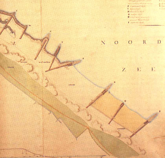
One vernacular technology closely related to the first, sedimentary process of barrier island formation is the groyne, typically a pile of material sunk into a waterbody (ocean, estuary, or river) perpendicular to the current of that waterbody, so as to arrest sediment and produce accretion. While the pile of material — often rock, though historically including more varied materials such as timber — is typically constructed in a solid line with a triangular section, groynes can also be constructed from sunk poles in what is referred to as a permeable groyne. Along beaches, groynes are typically used to slow or counteract processes of erosion, while in rivers they usually serve to halt the processes of accretion and erosion which produce river migration, with the aim of maintaining the navigability of rivers.
E. DREDGE AND FILL
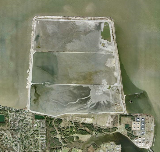
Islands, of course, also accumulate as the by-product of industrial processes, such as the dredging of river and estuary bottoms to maintain shipping channels. While these processes are not passive in the same sense as, say, the stimulated growth of a coral reef on sunken subway cars, they are interesting as industrial analogues to the natural processes of sedimentation and erosion which produce many islands. Industrially-constructed islands often become important wildlife refuges — what might be called “accidental parks” — as in the case of the site pictured above, Craney Island Dredged Material Management Area, which has become an important stop on the Atlantic Flyway, providing forage and nesting habitat for over 270 species of bird.

In other cases, industrially-constructed islands serve as the foundations for human settlements, whether accidentally (as in the case of Odaiba, originally constructed for military purposes), as fortuitous by-product of other construction activities (Manhattan’s Battery Park City, for instance), or through the intentional piling of seafloor sediment specifically extracted for island construction (as in the case of Dubai’s artificial islands).
[Update: Infranetlab’s first Glacier-Island-Storm post, “LandFab, or Manufacturing Terrain”, deals with “volcanic heroism, political anomaly, [and] development opportunism” as “catalysts of artificial, manufactured islands”, and explores several remarkable case studies.]
F. SEAMARKS, LANDMARKS, AND CIPHERS
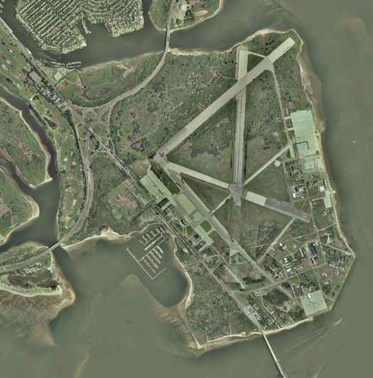
A few years ago, I had the pleasure of working with landscape architect Laurel McSherry and architect Terry Surjan on an entry to a Van Alen Institute competition, “Envisioning Gateway”. The competition took as its site Gateway National Recreation Area, one of the nation’s oldest urban national parks, which is scattered around New York Harbor, split between New York and New Jersey, and meeting three boroughs. The core of each entry to the competition was to be a proposal for a new park at Floyd Bennett Field, a thirteen hundred acre former municipal airport situated in Jamaica Bay, on land largely composed of fill from the dredging of channels within Jamaica Bay and the surrounding waterbodies.
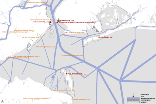
Our entry, entitled “Seamarks, Landmarks, and Ciphers”, was intended to serve as a “field guide” to the landscapes of Gateway, revealing hidden landscapes and making connections with distant landscapes:
Three types of connections – marks – are suggested to guide the revival of local and regional landscape knowledge: seamarks, landmarks, and ciphers. Located 1000 feet apart along cardinal directions, a field of sixty-two seamarks guide wanderers and inform observers of the locations and heights of future landform modifications. Varying in shape, size, and height, seamarks guide the creation of a midden – a near-continuous landform traveling the width of the site from the Gateway Marina to Mill Basin. Formed incrementally over a span of 11 years from local channel dredge, the midden serves as index (vertical) of the former Irish Channel bathymetry, datum both within and outside the site, and surrogate for the experience of an otherwise inaccessible landscape. The landmark field situates Gateway’s’ constructed landscape within the context of other national parks and monuments under the care of the Department of the Interior. The proposed series of stamp issues serves as cipher for the reading of Gateway’s local and regional landscapes.

The midden is perhaps the most relevant of these marks to a discussion of accretion and erosion. A midden is literally a “dung heap” or “refuse pile”, but it often refers to the piles of mollusk shells left by nomadic peoples or hunter-gathers along coastlines, often gaining such depth of accumulation that the middens appear nearly geologic in character, as in this photograph of a shell midden in Maine.
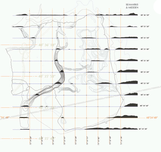
“Seamarks, Landmarks, and Ciphers” proposed to harness the deposition of fill from on-going local dredging by forming that fill into a midden tracing — at one-to-one scale and in-situ — the inverted bathymetry of the historical channels of Jamaica Bay, eventually producing a new artificial topography which would make tangible the enormity and scale of the industrial processes acting upon the bay. The midden would be constructed within a field of largely-shipwrecked seamarks, which would be marked with the heights of the coming depositions and so serve as forewarnings of the 2.5 million cubic yards of imminent industrial accretions.
G. MONSOON DESERT
While the term “monsoon” is often associated with the strong seasonal rainstorms produced by winds such as the southeast trade winds of the Indian Ocean, monsoon refers literally to any “wind system with pronounced seasonal reversal”, and so the Thar desert in Pakistan and the Rajasthan desert in India, both of which border the Indus river, are properly termed “monsoon deserts”. Though they drops the majority of their remaining moisture on the flanks of the Aravalli mountain range, the same monsoon winds which produce India’s famously wet summers sculpt the arid Thar and Rajasthan through eolian processes of deposition, producing a variety of crescentic, linear, and parabolic dunes. Because of the stability of the monsoon system, the South Asian monsoon deserts are also relatively stable, having settled roughly into their contemporary configurations after the conclusion of the last global ice age — so monsoon deserts are, in other words, deserts shaped by the continued predictability of storm patterns.
H. DIMETHYL SULPHIDE
A 2005 article in the New Scientist notes that corals appear to, through a feedback mechanism triggered by symbiotic relationships with bacteria inside their tissues, release the chemical dimethyl sulphide into the waves above them. As the chemical collects on the surface of the ocean, it is picked up by winds and “transformed into an aerosol of tiny particles on which water vapour can condense to form clouds”. Corals, in other words, produce an excretion which forms seeds for the accretion of water particles: these islands form their own storms.
This biological climate-modification system serves primarily to self-regulate the temperature of the coral seas, producing more clouds to cool the corals as temperatures rise, and less as temperatures sink. Unfortunately, a more recent study — also noted in the New Scientist, but only last week — indicates that sea temperatures may be rising significantly enough to disrupt the production of dimethyl sulphide, which will dramatically reduce cloud formation over the Great Barrier Reef and, in turn, produce rainfall shortages in the north Queensland rain forests which depend on clouds formed over (and, it seems, by) the Great Barrier Reef.
I. AN AUGMENTED ECOLOGY OF WILDLIFE AND INDUSTRY
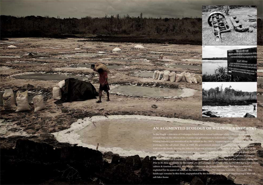
One of the few industries to survive for any length of time in the Galapagos islands is salt mining, as naturally saline lagoons have been exploited by salt harvesters for centuries. Unfortunately, one of the emblematic species of those islands, the Greater Flamingo, also depends on the same saline lagoons for habitat and food. Because of the damaging effects of salt mining on the lagoons, Greater Flamingos are no longer found on Santa Cruz, the most populous of the Galapagos islands.
Wen Ying Teh‘s “An Augmented Ecology of Wildlife and Industry”, a RIBA President’s Medal winning project last year, proposes a hybrid structure — part building, part extension of the ecological process of a saline lagoon — which could be inserted into one of the salt mines near Puerto Ayora, supporting the salt mining industry while restoring the ecological balance of the saline lagoon, drawing Greater Flamingos back to Santa Cruz.
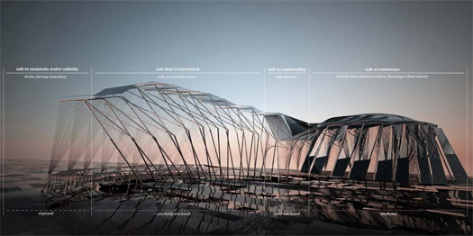
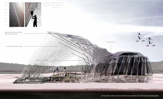
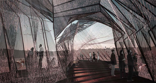
The structure, which hosts a brine shrimp hatchery, salt crystal harvestry, salt market, tourist education center, and flamingo observatory, protrudes linearly into the lagoon before fanning out into a series of tanks housing the brine shrimp. The skin of the structure is composed of hanging nylon threads, which wick salt from the lake through capillary action, crystallizing a mineral skin that is cyclically harvested by the salt miners, so that the building pulses through the seasons with the wax and wane of sodium chloride. Because the miners no longer need to disturb the lagoon to harvest salt, the natural balance of the lagoon can be restored.
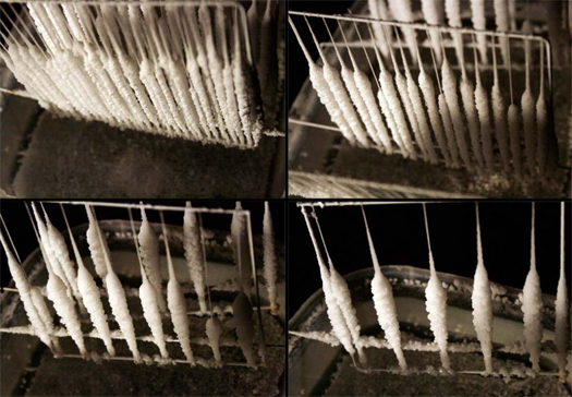
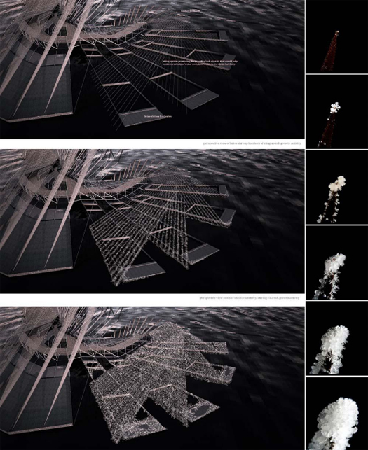
In Wen Ying Teh’s project, the building itself is constituted by processes of accretion and erosion: salt accretes to form the skin through capillary action, and then is eroded, both by harvesting and by rain, with the latter process of erosion being tied into the maintenance of proper salinity for the shrimp hatchery. The structure serves as an extension of the lacustrian ecosystem, not just physically, but in time and process. While in some ways this is an amplification of processes that already occur on buildings — eroding as they weather, accreting objects, paints, memories, and so on as they’re occupied and augmented and built upon — making accretion and erosion not just ancillary to the architecture, but central to it, remains an unusual and beautiful approach.
I first saw Ying’s project at dpr-barcelona; Ying’s tutors were Kate Davies and Liam Young, of the always-interesting Tomorrow’s Thoughts Today.


Great Post.
The U.S. Geological Survey just completed a new computer simulation model of the Missoula floods event, providing a play by play view of the 55+ hr inundation. The Oregonian had a write up on it just a couple days ago:
http://www.oregonlive.com/news/index.ssf/2010/02/geologists_find_a_way_to_simul.html
Thanks — great link and map of the flood simulation.
Thanks for the thorough post – it’s a great addition to the glacier/island/storm argument. I think your first note about the inflexibility of architecture when dealing with natural, unstable processes is something to be explored. It’s certainly something I’ve been grappling with in a studio project relating to glaciers.
How does one design architecture (something inherently static) for an object (glaciers specifically) whose one defining quality is movement. I’m torn between two of many possible solutions: Do you create a built environment that will force this natural process to adapt to its new surroundings and therefore become nondynamic too in which case it loses part of its being (can you consider a glacier that doesn’t move a glacier anymore)? Or do you design for the inevitable destruction of such built environment where the glacier wins?
Great questions. More which occur to me:
Or would you design a structure which rides the glacier? If buildings can ride earthquakes and houses can float on rivers, why couldn’t they ride glaciers? The binaries you outline are obvious, but are oppositions the only option?
I love the structure “riding/surfing” the glacier idea. That seems like it could be worth pursuing.
“Surfing” is exactly the other word which I nearly used…
…the great thing about the word is what it implies for the building — that it would be literally unstable, but dynamically stable; that it would constantly be compensating for shifting forces; that it would need to be intelligent, at least in a structural sense.
taking glacier surfing quite literally
I think the strongest building design (metaphorically speaking, but perhaps structurally too), could be one that indeed shifted with the forces of a natural occurrence. That’s where architecture falls apart – when it cannot adapt to the forces around it, as mentioned before with earthquakes, hurricanes, floods, tides, etc.
It’s an exciting thought to think of a piece of architecture that could not only influence these natural processes but adapt to them as well, creating a symbiotic relationship.
sorry, the link didn’t post:
taking glacier surfing quite literally:
http://www.youtube.com/watch?v=mKRR9RMmcIQ
Agree with all the above, but I would also note that the building doesn’t necessarily need to move along with the glacier to embrace its kinetic properties. A simplistic example of this kind of thinking would be a structure built on ‘solid’ ground near the glacier with, say, cor-ten steel and a path for building runoff which empties over the glacier, creating a trail of reddish orange on the surface of the glacier measuring its progress (and probably a whole lot more – the fading of the tail of the reddish stain could show mixing of glacier ice, it’s width a metric of the amount of runoff over the structure, caused by the local climate, etc). It’s just a bit of steel and some topographic massaging, but is nonetheless intimately tied to contextual flux.
[…] has already suggested that glaciers, islands and storms may be understood as events; but another way to read these events […]
[…] “Geofluidic Landscape” (and even the Galapagos salt mine project which mammoth described earlier this week), the museum suggests a serious and near-total integration of building and […]
[…] self-sustaining, tectonically complex structures of ice into motion. After all, glaciers are very long events, as mammoth memorably put it. [Image: From Wired Science’s photo gallery, “Stunning Views of […]
[…] talk, they would be able to tell the story of the events that formed them. Our friends from mammoth recently wrote that a glacier is a very long event, an making a paraphrasis we can also say that a crater is also […]
[…] self-sustaining, tectonically complex structures of ice into motion. After all, glaciers are very long events, as mammoth memorably put it. [Image: From Wired Science’s photo gallery, “Stunning Views of […]
[…] all, glaciers are very long events, as mammoth memorably put […]
[…] competition, “Dynamic Coalition” (which mammoth described and discussed previously, near the middle of this post, which is concerned with larger questions of stability in design), as an example of a project that […]
[…] us the Glacier/Island/Storm studio at Columbia GSAPP by Geoff Manaugh. As Rob Holmes pointed on mammoth: A possibility: glaciers, islands, and storms are as much events as they are objects; as events, […]
[…] barren, rocky valleys. Mammoth looked at that event, the Missoula Floods, in a post last year, "a glacier is a very long event". (You'll want to scroll down to "Jokulhlaups".) We might add that, if contemporary land use […]