mammoth // building nothing out of something

visibility


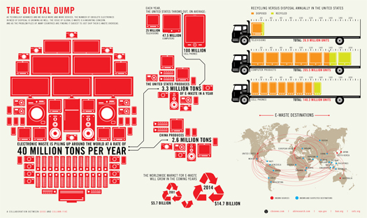
[“The Digital Dump”, a graphic about e-waste from Good.is‘s “Transparency” series and Column Five Media.]

Mostly for our own purposes (keeping track of things we see), we’ve started Visibility, a tumblr collecting items related to An Atlas of iPhone Landscapes. I make no promises about how frequently it will or won’t be updated, but if you’re particularly interested in the topic, you can follow the tumblr or grab the feed.

eight-bit baroque

Via BLDGBLOG, Timo Arnall’s “Robot Readable World”, “an experiment in found machine-vision footage, exploring the aesthetics of the robot eye”:

This video is rather obviously fantastic, but I do think it’s worth calling attention to a perceptive comment left on the Vimeo page. Arnall describes the video as exploring the questions “how do robots see the world?” and “how do they gather meaning from our streets, cities, media, and us?”, which is obviously in-line with the line of inquiry set up by Matt Jones (like Arnall, of BERG) in his talk (well worth reading) on the robot-readable world, which explores “the evolutionary pressure of… three billion (and growing) linked, artificial eyes on our environment”. The comment that I mentioned, though, from Greg Borenstein, notes that the video, while it certainly succeeds in exploring the aesthetics of the robot eye, is perhaps not in fact so directly interacting with the question of “how robots see the world”:

I keep thinking about whether these are equivalent to the Terminator HUDs that Slavin mocks (images.wikia.com/terminator/images/2/25/T-800a_Threat.jpg). Why would a computer communicate to itself with text? These visualizations are really for the human observer of the CV process. They’re akin to Rodney Brooks’s idea of language having been invented by god to make it easier to read our minds. In this case these graphics give a window on the extent to which the CV algorithms are seeing the world the way we want them to, whether their vision agrees with ours. It’s not an internal representation, it’s a performance for our benefit. Like Kyle, find myself doing a dance of rapidly connecting the displays with the semantics of what they represent: arrows for flow, boxes for blobs, etc. These graphics were designed by people to be seen by other people. They’re meant to let us see how the algorithm is doing. It’s only an internal state of the computer to the extent to which conversing is mind reading.

Insofar as the aesthetic (or “new aesthetic”) of this robot-readable world is not, in fact, a purely robotic aesthetic, but rather a translation of the algorithmic “reasoning” of these robots into a visual language that makes their reasoning human-readable, I find that this makes Manaugh’s suggestion of a “landscape architecture for machines” at least partially composed of “future gardens optimized for autonomous robot navigation” all the more intriguing, as an intermediary aesthetic that sits between the robot and the human might be the perfect aesthetic for constructing baroque vegetative monuments to the robot-readable world: Vaux-le-Vicomtes of comfortably pixelated topiaries, to be enjoyed by both the Google Car and Sergey Brin. (It’s worth noting here that the French Baroque is typically understood as embodying an interest in demonstrating the imposition of human Order on floral Nature, which also suggests some precedent for a Robot Baroque, monumentalizing the literal interface between the human and the robot.)

[Also worth reading — BLDGBLOG’s speculations on “object cancers”, or a “kind of robot-blocking world” as a “corporate response to the robot-readable world.]

munitions landscape


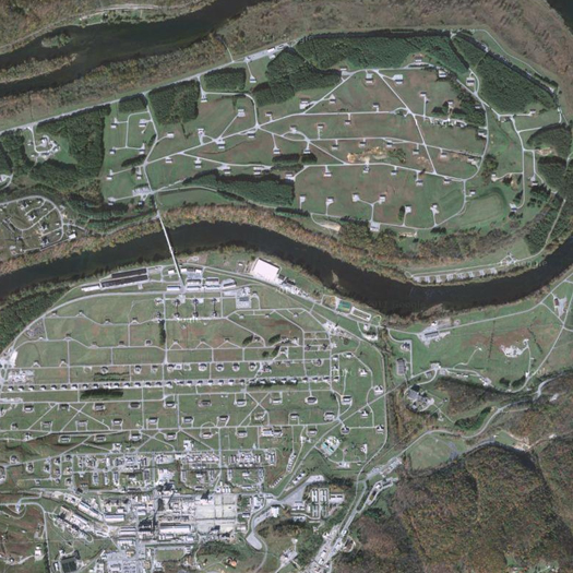
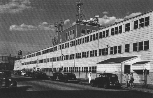
[The Radford Army Ammunitions Plant on the New River, in southwest Virginia.]

FASLANYC takes us on a tour of particularly bizarre militarized landscape typology — the World War II-era munitions plant, beginning with the Radford Army Ammunitions Plant in southwestern Virgina. Digging into the archives at the Historic American Landscapes Survey, Davis excavates the fascinating generative logic governing the spatial patterns of these sites:

Buildings used in the first stage of the process, where the material handled is highly flammable but not explosive, are grouped together in a section known as the “cotton area.”  Those used in the second stage, where the material handled is highly explosive, are widely spaced and form what is called the “powder line.”  Material is conveyed from one building to another first by flumes, then by motor trucks, and finally- when the highly explosive stage is reached- by small hand carts.

… From here on a unique type of construction, adapted to handling explosive materials, is required.  All of the buildings in the powder line make use of “blow out” construction designed to control the direction of an explosion through one or more extremely light screens which will “blow-out” with a minimum increase in the air pressure within the building.

A second method of limiting the effects of explosions… is used in the solvent recovery buildings and those in the finishing area, which are spaced from all other buildings and from each other and surrounded by barricades.  Spacing varies according to the maximum amount of explosive which is to be processed or stored in the building at any one time.

Barricades are constructed of heavy timbers with a plank face on each side and a screened dirt fill, making a solid wall with an average of approximately 5-foot thickness to absorb the shock of any possible explosion.  Their height roughly corresponds to the height of the buildings they surround.

Read more at FASLANYC. As he suggests, this adds an important twist to the study of militarized landscapes — expanding beyond demilitarized zones, cities under permanent siege, and military abandonia to include the industrial landscapes that literally fuel the production of those other places.

urbnfutr interview with liam young

In an interview with URBNFUTR, Liam Young describes how he sees the relationship between his training as an architect and his current work as the head of “urban futures think tank” Tomorrow’s Thoughts Today:

As architects we span the gulf between the cultural and the technological, we are in a unique position to synthesize complex factors – social, technical, cultural, political, environmental – and to pose alternate scenarios. Architecture is typically such a slow medium, however, and we wanted to develop alternative strategies for how a designer may operate and alternative forms of projects that could play out with much more immediacy. So we have gravitated to the discipline of futures as we explore the idea of a think tank as a legitimate model for an architectural practice – a practice not built on buildings as endpoints but on speculations, research and futures as products in themselves [emphasis mine].

Should this be the only model for architectural practice? Of course not (and I do not read Young as suggesting that it should be). It does, however, strike me as an important option among possible directions that the expansion of the field of architecture can and should take, particularly given the quantity of historical precedent that can be found for this role for the architect. (One of the more interesting challenges for this model — which I’m going to avoid exploring here — is how it can be financially self-sustaining.)

I was also intrigued by his thoughts on the importance of Hertzian space to the future role of the architect, because they remind me that this is, as far as I am aware, essentially unexplored terrain for landscape architecture — which seems slightly odd, given that it could easily be argued that Hertzian space is more akin to landscapes than buildings, as it is composed of fields and wavelengths and held together by networked infrastructures in fluctuating communication. Having noted that, it seems entirely natural that Young — whose work is deeply entangled with landscape — would be asking these questions:

One of the critical questions we are asking ourselves at the moment is what do we do as architects in a near future where the dominant building material exists outside the physical spectrum. The infrastructure that drove the development of the city was once large permanent networks of roads, plumbing and park spaces but are now nomadic digital networks, orbiting GPS satellites and cloud computing connections. Cities are being planned around the speed of electrons, satellite sight lines and big data. Connection to wifi is more critical than connection to light. The city must be planned around the mobile phone not the automobile. Today we are much closer to our virtual community than we are to our real neighbours. This death of distance has created new forms of city based around ephemeral digital connections rather than physical geography.

These changes mean we must rethink the very core of what our profession is. It is true that there will still be physical objects and spaces that some sort of architect like character will have to engage with but this window of operation is becoming increasing narrow.

While this seems perhaps a bit oppositional — I’d argue that both the mobile phone and the automobile are critical to the construction of the contemporary city (and I suspect Young is at least in part producing the opposition for rhetorical effect) — I think Young is entirely correct in tying issues like the rise of Hertzian space and disappearance of wild nature in favor of anthropogenic nature to the need for an expanded “window of operation”.

spanish bubble landscapes


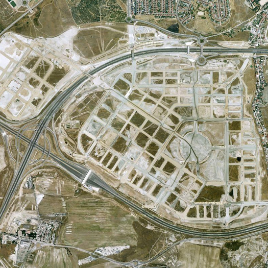
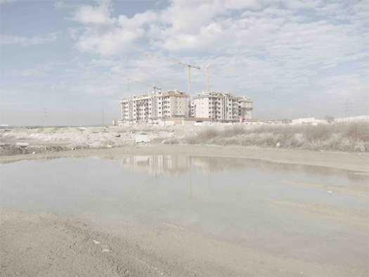
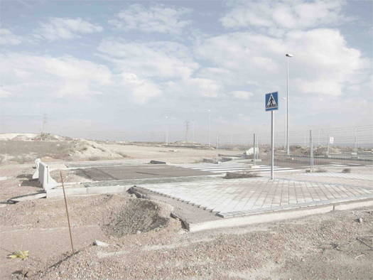
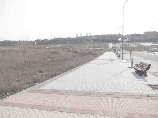
[Suburban abandonia on the outskirts of Madrid, via google maps.]

During the presentations at Visualizar last summer, one of the presenters (I think it was José Luis Muñoz Muñoz, but I haven’t re-watched his presentation, so I’m not totally sure) mentioned a photography project that sought to document the post-bubble abandonment of parts of the suburban fringe of Madrid. I’m not certain what project that was (clearly, I took very bad notes), but I’ve since run across two that document roughly that same landscape, one from the always-stimulating blog deconcrete and the other in Quaderns. Given my interest in tracing the landscapes of financialization (and, of course, the role of financialization in fueling rampant development), I thought it’d be worth linking to those two projects.


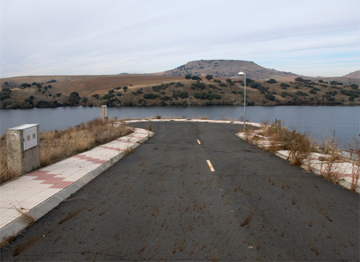
[Photographs from Julia Schulz-Dornberg’s “Modern ruins, a profitable topography; visit the gallery at Quaderns for additional images.]

The first, Julia Schulz-Dornberg’s “Modern ruins, a profitable topography”, is described as “a photographic inventory of abandoned speculative construction in Spain”. Schulz-Dornberg’s argument that these developments constitute a “profitscape”, or a constructed landscape whose primary intended characteristic was its capacity to transform land into a standardized commodity, reminds me of mammoth‘s own ruminations on the American suburban home as a machine for generating wealth — in both cases, the apparently aberrant physical characteristics of the designed object in question are made readily understandable by reading the object as a financial instrument first and a shelter/neighborhood second.


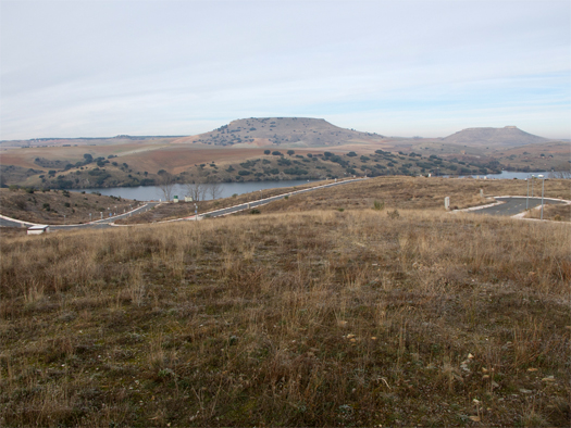
[Photographs from Daniel Fernández Pascual and Luis Galán García’s “A Road Trip through Madrid’s Bubble Challenge”.]

The second is “A Road Trip through Madrid’s Bubble Challenge”, from deconcrete‘s Daniel Fernández Pascual and Luis Galán García. It is concerned with the immediate environs of Madrid, where some forty-seven thousand apartments wait for buyers (or, were waiting in 2009) while “hundreds of kilometres of perfectly paved streets run between eerie blocks, waiting for… construction”. Intriguingly, they speculate that these abandoned bubble landscapes might, at least for some time, function as de facto wilderness parks — perhaps a bit like Sterling’s involuntary parks, but with collapsed credit systems in the place of razor wire and mines.

an atlas of iphone landscapes


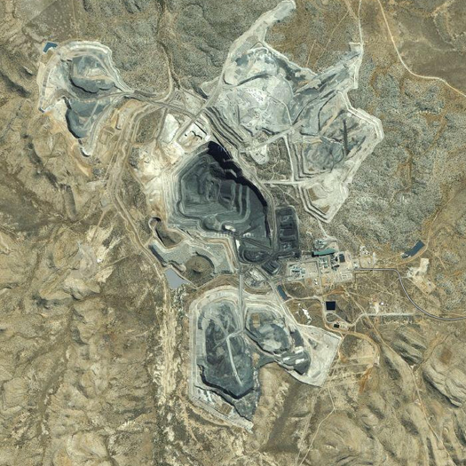
[MMG Century, in northwest Queensland — the world’s second-largest zinc mine, owned and operated by the Chinese metals conglomerate China MinMetal. MMG Century features prominently in the talk below.]

1 Note that if you are reading this indirectly, i.e. on Google Reader, you may not see the video below.

1. A conversation the other day reminded me that I never posted the talk I gave at Visualizar last summer. This happened, I think, both because I have a bunch of half-written posts about the other (really interesting!) content of the seminar and because I’ve had some intention of providing the text from the talk along with the video. But since I clearly am not going to get around to either of those things anytime soon, it seems like I should go ahead and post the video1.

The talk is an extension of one of my favorite posts, a preliminary atlas of gizmo landscapes, which attempted reconsider the iPhone, not as a discrete, independent hand-held device (“the phone that magically has the internet in it”, which I think is more or less how Apple wants you to think of it), but as a networked object that both produces and is produced by a wide array of distant and not-so-distant landscapes, from zinc mines to Fed-Ex distribution hubs. The talk starts off a bit slow, maybe, as I probably spent more time than most viewers will want explaining how I thought this line of research fit into the wider task of the seminar, but I still think it’s pretty interesting, especially once the tour of iPhone landscapes gets going. (Basically, if you’re bothering to read mammoth, you’ll probably enjoy the talk.)

2. Relatedly, the iPhone’s manufacturing chain — what I call the iPhone’s landscapes of manufacture and assembly in the atlas talk — has been the subject of several recent news stories.

This American Life’s excellent “Mr. Daisey and the Apple Factory” begins with an excerpt from Mike Daisey’s one-man show about his trip to Shenzhen — which began when Daisey saw a few photos of the inside of an iPhone factory, and was shocked by the absence of robots. Once in Shenzhen, Daisey works out a plan to get inside the factory zone:

“And two days later we head out into the factory zone. As we come to each factory, Kathy briefs me on what it is they make and what it is I have said I am going to buy. The factories are all different, but really they’re more similar than different. There’s always gates and guards. When you get past those, there’s always a lawn, big and green and plush. No one walks on it. No one uses it. You go into the lobbies. The lobby is these huge empty Kubrickian spaces, totally empty except for a tiny little desk for the receptionist.

And you cross the huge, empty lobby to the tiny little desk. You introduce yourselves, and then the executives always come down in a gaggle, all together. They pick you up, and you go up together to a conference room.

After the PowerPoint, we head down to the factory floor, industrial spaces with 20,000, 25,000, 30,000 workers in a single enormous space. They can exert a kind of eerie fascination. There’s a beauty to industrialization on such a massive scale. You don’t have to deny it. There’s a wonder to seeing so much order laid out in front of you. And people are walking around, whispering statistics in your ear.

It’s easy to slip into a kind of Stalinist wet dream, but I try to subvert that by locking onto actual faces. They take me up and down the aisles. And the first thing I notice is the silence. It’s so quiet. At Foxconn you’re demerited if you ever speak on the line.

At no factory I went to did anyone ever speak on the line, but this is deeper than that. As a creature of the First World, I expect a factory making complex electronics will have the sound of machinery, but in a place where the cost of labor is effectively zero, anything that can be made by hand is made by hand. No matter how complex your electronics are, they are assembled by thousands and thousands of tiny little fingers working in concert. And in those vast spaces, the only sound is the sound of bodies in constant, unending motion.

And it is constant. They work a Chinese hour, and a Chinese hour has 60 Chinese minutes, and a Chinese minute has 60 Chinese seconds. It’s not like our hour. What’s our hour now, 46 minutes? You know, you have a bathroom break, and you have a smoke break. If you don’t smoke, there’s a yoga break. This doesn’t look anything like that. This looks like nothing we’ve seen in a century.”

The excerpt from Daisey’s show is followed by reporting that confirms what Daisey saw in Shenzhen. You can listen to the piece online here (there’s also a transcript, if you prefer to read), or download it from the iTunes store (ironic!) for a nominal fee.

Second, the CEO of Foxconn, Terry Gou, seems determined to correct the perception that his company dehumanizes its workers, as Business Insider reports:

“According to WantChinaTimes, Terry Gou, the head of Hon Hai (Foxconn), the largest contract manufacturer in the world, had this to say at a recent meeting with his senior managers: “Hon Hai has a workforce of over one million worldwide and as human beings are also animals, to manage one million animals gives me a headache,” said Hon Hai chairman Terry Gou at a recent year-end party, adding that he wants to learn from Chin Shih-chien, director of Taipei Zoo, regarding how animals should be managed.

As WantChinaTimes put it, Gou “could have chosen his words more carefully.” But Gou had indeed invited the zoo director to speak to Hon Hai’s top managers in the hope that the zoo-keeper’s advice would help them do their jobs better.”

Charming.

Finally, the New York Times ran a lengthy piece on “Apple, America, and a Squeezed Middle Class”, which explores Apple’s decision to relocate the bulk of its manufacturing operations from the United States to China over the past decade:

“Though components differ between versions, all iPhones contain hundreds of parts, an estimated 90 percent of which are manufactured abroad. Advanced semiconductors have come from Germany and Taiwan, memory from Korea and Japan, display panels and circuitry from Korea and Taiwan, chipsets from Europe and rare metals from Africa and Asia. And all of it is put together in China.

In its early days, Apple usually didn’t look beyond its own backyard for manufacturing solutions. A few years after Apple began building the Macintosh in 1983, for instance, Mr. Jobs bragged that it was “a machine that is made in America.” In 1990, while Mr. Jobs was running NeXT, which was eventually bought by Apple, the executive told a reporter that “I’m as proud of the factory as I am of the computer.” As late as 2002, top Apple executives occasionally drove two hours northeast of their headquarters to visit the company’s iMac plant in Elk Grove, Calif.

But by 2004, Apple had largely turned to foreign manufacturing. Guiding that decision was Apple’s operations expert, Timothy D. Cook, who replaced Mr. Jobs as chief executive last August, six weeks before Mr. Jobs’s death. Most other American electronics companies had already gone abroad, and Apple, which at the time was struggling, felt it had to grasp every advantage.

In part, Asia was attractive because the semiskilled workers there were cheaper. But that wasn’t driving Apple. For technology companies, the cost of labor is minimal compared with the expense of buying parts and managing supply chains that bring together components and services from hundreds of companies.

For Mr. Cook, the focus on Asia “came down to two things,” said one former high-ranking Apple executive. Factories in Asia “can scale up and down faster” and “Asian supply chains have surpassed what’s in the U.S.” The result is that “we can’t compete at this point,” the executive said.”

This is a particularly interesting supplement to the component of my talk that touches on manufacturing because while I focused on Longhua Science and Technology Park — the FoxConn factory-city in Shenzhen — and the kind of place that it is for those who live and work in it, the Times article explains that the appearance of Longhua, which I described as “the iPhone city”, required the disappearance of  another city, back in the United States. (This makes it a similarly good supplement to the This American Life piece, for the same reason.) There’s a huge set of issues tied up in the relationship between Longhua and Elk Grove, as the article indicates, from the ethics of labor conditions to the rise of logistics landscapes as the key node in global trade chains to the disappearance of the manufacturing jobs that formed the foundation of the American middle class (and corresponding “job polarization”).

(A second article in the New York Times series on the “iEconomy” is similar in theme and content to the This American Life show, looking at the “human costs to workers” of iPad manufacture.)


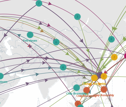
[A snapshot of “Laptop Computer” by user Leo on Sourcemap.]

3. Another related note: James Bridle recently posted a link on his “New Aesthetic” tumblr to the above map, which is intended to lay out the supply chain involved in the production of a typical laptop computer. (The same user who created that map, “Leo”, also has a nice map for the “material composition of a mobile phone circa 2006”.)

The site that this map is hosted on, Sourcemap, describes itself as “the crowdsourced directory of product supply chains and carbon footprints”, which makes it a sort of broad-based platform for the creation and distribution of exactly the kind of industrial material genealogy that I tried to perform with the iPhone in my talk. Which is to say that I think it is a fantastic idea.

delaware dredge


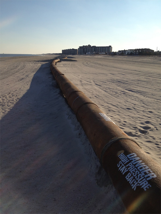
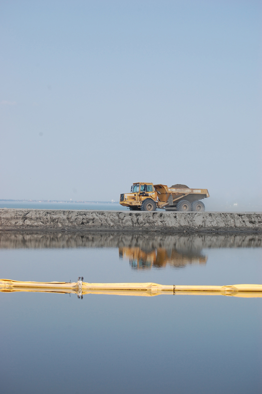
[A pressurized pipe carries dredge along Bethany Beach, Delaware; photography by Chris Mizes.]

On his blog space within lines, Chris Mizes writes about one of the more common ways that the landscapes of dredge intrude on everyday life: beach nourishment.

As Mizes explains, this commonplace instance of landscape prosthesis is — like many of the landscapes of dredge — quickly revealed as bizarre and otherworldly, when the initial simplicity of the operation (“they’re putting more sand on the beach!”) is peeled back to reveal conflicts between lunar and terrestial gravitational pulls; miles of potentially hazardous pressurized tubing and tourist escapes; the natural and the anthropogenic; and so on.

Read Mizes’ full post here.

schafran on race and foreclosure

Speaking of the geography of financialization, Alex Schafran had a fantastic post at Polis last December on race, foreclosure, and rhetoric surrounding the “death of the fringe suburb”.

In forthcoming work done with my colleague Jake Wegmann, analyzing real-estate data in the region since 1988, we can show that the zip codes to which African Americans migrated were doing well in terms of median home value until 2005, long after the migration had begun. Not just well overall, but well against San Francisco’s Cole Valley, one of the most gentrifying places around. Their presence in the fast growing portions of deep suburbia did not cause the crisis, and their decision to move made sense. If you were black and middle class, moving to places like Antioch and Patterson seemed like a good deal — a chance at a piece of the American pie and a rational economic decision. Nobody realized how shaky the terms of the deal would turn out to be.

This is one of the many reasons that Chris Leinberger needs to change his tune. I agree that sprawl was a bad idea, that growth on the fringe helped bring the economy down and that urban centers are the heart of our global future. We’ve known this since suburbanization began in earnest two generations ago. But we failed to stop it.

Now the “fringe” in Northern California alone is home to millions. And in the 24 Bay Area cities [analyzed by Schafran], almost half a million of the 850,000 residents are not white. These are generally hard-working families who followed the same suburban path the white masses went down a generation or two ago — except much farther from city centers and with worse debt, less job security and no real mass transit. This is a generational raw deal hatched at every scale of our urban development.

The foreclosure crisis is a national tragedy that hand-wringing about the failures of sprawl will not undo. Predicting the “death of the fringe suburb” is reminiscent of the harmful language used to describe cities in the days before urban renewal, when we labeled the neighborhoods of the working classes and communities of color as “slums” and “ghettos,” bulldozing what we could and redlining the rest. This massive and exceptionally racist failure of urban policy in the post-war era laid the groundwork for this crisis more than a half century ago. While we were busy destroying inner cities and building nice suburbs, we denied African Americans the right to move out as well.

Schafran’s post is well-worth reading in full, particularly for the compelling maps he has produced.

Why is this a landscape whose origins can be traced at least in part to financialization? There are a number of reasons, including the disproportionate impact of public-sector austerity (and accompanying job losses) on the African-American middle class that Schafran refers to, the general hunger for exurban expansion produced by the reliance of the various invented products at the heart of the financial crisis — collaterialized debt obligations, credit default swaps, and so on –on a steady supply of new homes and fresh mortgages, the role of the financial sector in foreclosure fraud, and the ties between the mortgage market and the shadow banking system.

[Friend-of-the-blog Peter Nunns also wrote about Leinberger and Schafran’s posts. Also, earlier posts on mammoth in defense of understanding suburbia and on the American home as a (now-busted) machine for making money.]

dry commonwealths

[The eighty-six proposed “commonwealths” of the lower forty-eight states, from “The Commonwealth Approach”.]

1 I can’t take too much credit for our win — we borrowed the main idea from a pair of earlier competition entries Laurel produced.

I’m excited that “The Commonwealth Approach”, an entry to the Arid Lands Institute’s Drylands Design Competition that I worked on with Laurel McSherry1, has been selected for a research prize by the competition jury. Taking a bit of inspiration from John Wesley Powell, we proposed re-organizing the political geography of the United States, beginning with the replacement of the fifty states with ninety-three “commonwealths” whose borders are based on water resource geography. Our paragraph on “geography and bias” explains part of the motivation behind this seemingly impractical proposal:

“Political geography — the location of bureaucracies, the subdivision of a nation into smaller units, the position of symbolic power centers like the U.S. Capitol — biases decision-making.  In the United States, and with specific reference to water, the position of the federal government, its siting in the District of Columbia on the eastern edge of the continent, produces a bias against understanding the full consequences of the aridity of the half of the nation that lies west of the 100th Meridian.

This political geography constitues an organizational architecture which precedes, constrains, and produces site architecture.”

One of the nice things about this award is that, unlike many competitions where the winning entries are selected and never developed any further, the research prize gives us the opportunity to progress our design research over the next couple months, towards public presentation as a component of the Drylands Design Conference at Woodbury University in Burbank at the end of March.

Consequently, this post is just a bit of a tease — a much fuller report will be forthcoming after we’ve finished our current work.

The other eight winning entries, including four more research award winners and various honor and merit awards, can be found on the Drylands Competition website.

metro international trade services


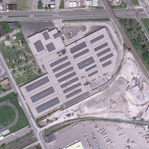
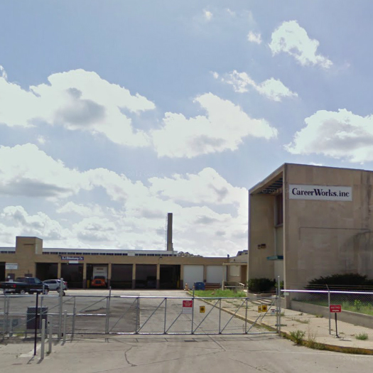
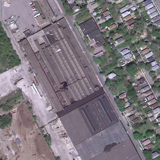
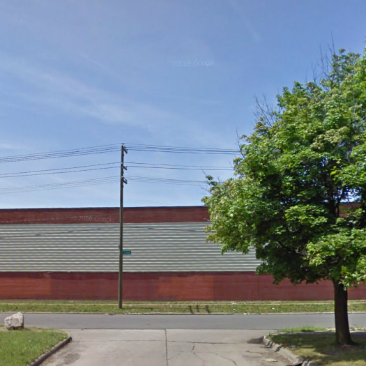
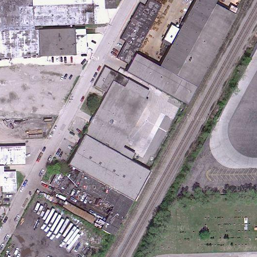
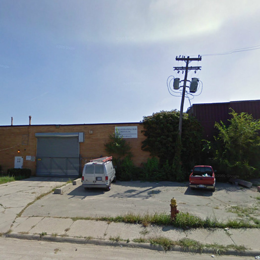
[Warehouse at 1200 E McNichols Road, Highland Park, Michigan. The small red sign at the bottom right corner of the second image says “Metro”.]

The warehouse above — and a network of others like it, scattered around the industrial abandonia of Detroit — is a crucial bottleneck in the global aluminium trade.

Before I explain how this is, though, a bit of background.

1 Kevin Slavin’s fantastic talk “How algorithms shape our world”, which I’m hoping to write something a bit longer about soon, would be a classic of that genre.

2 One of the things that makes that corporeality important is that, while much of the systemic perversity of financialization — like, say, the creation of synthetic CDOs — is intentionally obscure, the perversity of the landscapes that arise from financialization is often obvious, as the case of Metro International Trade Services will, I think, make clear.

3 Alexis Madrigal (author of the linked “flash crash” articles) also wrote about a similar case of “bizarre robot traders”:

“Mysterious and possibly nefarious trading algorithms are operating every minute of every day in the nation’s stock exchanges.

What they do doesn’t show up in Google Finance, let alone in the pages of the Wall Street Journal. No one really knows how they operate or why. But over the past few weeks, Nanex, a data services firm has dragged some of the odder algorithm specimens into the light.

The trading bots visualized in the stock charts in this story aren’t doing anything that could be construed to help the market. Unknown entities for unknown reasons are sending thousands of orders a second through the electronic stock exchanges with no intent to actually trade. Often, the buy or sell prices that they are offering are so far from the market price that there’s no way they’d ever be part of a trade. The bots sketch out odd patterns with their orders, leaving patterns in the data that are largely invisible to market participants.”

Something that I’ve become increasingly interested in the past year — and consequently am collecting a series of related items I hope to post — is the physical geography of global financialization1. I think my interest comes from roughly the same place that my interest in the material infrastructure of the internet (and other hertzian spaces) does — recognizing that, like the internet, global financialization is obviously non-corporeal and, at the same time, less obviously but quite importantly corporeal2. (By corporeal in these cases, I mean both sustained by a complex network of physical infrastructures and generating various indirect physical products through influence within economic, social, and political systems). Financialization is also, like the internet, a thing that exists only in aggregate, its behavior governed by the interaction of a myriad of smaller parts which are directed by a multiplicity of potentially conflicting desires. As a consequence, both things — financialization and the internet — have extremely jagged edges, weird dark spots where aggregated lower-level behaviors manifest as bizarre meta-behaviors. As an example, the intersection of those two sets of dark spots is particularly weird: like last May’s “flash crash”, where “a single large sell order executed by a rather crude software program sent the already-stressed market into a downward spiral”, causing the Dow to drop “10 percent in just minutes”3.

But given that my interest is particularly in the moments where those weird behaviors are spatialized, finding form in buildings and landscapes, this post exists, as I suggested earlier, to highlight a specific point in the physical geography of global financialization: the Detroit warehouses of “Metro International Trade Services”.


[4815 Cabot Street, Detroit, Michigan.]

I was reminded of this peculiar company by the recent news that big banks — the global players from the financial crisis that are household names, like Goldman Sachs, J.P. Morgan, and Barclay’s — have been threatening to block the sale of a much less widely known organization, the London Metal Exchange. To explain why those banks, which own large shares in the LME, would want to prevent the sale of the London Metal Exchange, you have to understand what Metro International Trade Services is, and something of its materially bizarre business model:

“In a rundown patch of Detroit, enclosed by a cyclone fence and barbed wire, stands an unremarkable warehouse that investment bank Goldman Sachs has transformed into a money-making machine.

The derelict neighborhood off Michigan Avenue is a sharp contrast to Goldman’s bustling skyscraper headquarters near Wall Street, but the two operations share one important element: management by the bank’s savvy financial professionals.

A string of warehouses in Detroit, most of them operated by Goldman, has stockpiled more than a million tonnes of the industrial metal aluminum, about a quarter of global reported inventories.

Simply storing all that metal generates tens of millions of dollars in rental revenues for Goldman every year.”

3 The London Metal Exchange has a simple and legitimate reason for warehousing:

“The LME certifies and regulates the Detroit sheds as part of a global network of more than 640 warehouses. The network is meant to even out swings in volatile metals markets. During recessions, surplus metal can be stored until economies recover and demand picks up, when the metal can be released.”

But — rather problematically — “that function is now being undermined by the backlog in Detroit” — as Goldman Sachs drives up prices by releasing as little metal as it legally can.

So the way that the business model works is essentially this: through its subsidiary Metro International Trade Services, Goldman owns these Detroit warehouses which are stuffed with this vast quantity of aluminum — as the article at Reuters says, more than a million tonnes, a quarter of global inventories. The stuffing, though, is done by the London Metal Exchange3, which owns the metals in the warehouses, and consequently Goldman Sachs ends up making a great deal of money off the rent that the London Metal Exchange pays to Metro International Trade Services — even though Sachs is one of the major owners of the London Metal Exchange. (Goldman bought the warehousing company in 2010, in a wave of purchases of metal warehousing companies by global financial institutions seeking to use the rising price of physical commodities as a hedge against their poor performance in commodity trading.)


[13542 Helen Street, Detroit, Michigan.]

Meanwhile, as Goldman is collecting huge rents from the London Metal Exchange off its stockpile of aluminum, American aluminum buyers are starved of the metal they want to purchase:

The long delays in metal delivery have buyers fuming. Some consumers are waiting up to a year to receive the aluminum they need and that has resulted in the perverse situation of higher prices at a time when the world is awash in the metal.

“It’s driving up costs for the consumers in North America and it’s not being driven up because there is a true shortage in the market. It’s because of an issue of accessing metal … in Detroit warehouses,” said Nick Madden, chief procurement officer for Atlanta-based Novelis, which is owned by India’s Hindalco Industries Ltd and is the world’s biggest maker of rolled aluminum products. Novelis buys aluminum directly from producers but is still hit by the higher prices.

Madden estimates that the U.S. benchmark physical aluminum price is $20 to $40 a tonne higher because of the backlog at the Detroit warehouses. The physical price is currently around $2,800 per tonne. That premium is forcing U.S. businesses to fork out millions of dollars more for the 6 million tonnes of aluminum they use annually.

4 When producers fear a slowdown, they go to banks — like Goldman — to finance metals: “in a typical financing deal, a bank buys metal from a producer, agrees to sell it at some future point at a profit, and strikes a warehouse deal to store it cheaply for an extended time period.”

But, because of an archaic rule system under which the London Metal Exchange specifics minimum daily metal release requirements by the city rather than by the warehouse (“at the moment, a warehouse operator needs to deliver just 1,500 tonnes a day per city, whether it owns one warehouse there or dozens”), Goldman has every incentive to concentrate the physical position of the aluminum it is storing in a single city — Detroit. This is because the less metal is released, the more money Goldman makes, primarily off the rent on its warehouses, but also potentially on the commodities exchange4. On the other end, the London Metal Exchange gets a one percent take of all rents in all the warehouses it approves, which hardly incentivizes the Exchange to adjust its release rules, even failing to account for the fact that Goldman owns a large portion of the Exchange.

And that’s why a quarter of the world’s supply of “available aluminum” is sitting in warehouses in Detroit, warehouses which are “a whirl of activity in the early hours of the morning when metal is usually delivered for storage”, but deserted throughout the rest of the day — because the aluminum goes in, but it only very slowly comes back out.

[I originally came across the story of Metro International Trade Services in this post by Umair Haque.]

emergency interventions


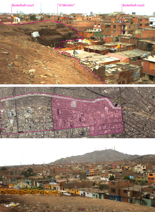
[One of the five sites for OPPTA’s 2012 competition, “El Monton”, “an accumulation of stratified waste classified as public space” by the city of Lima, in the impoverished riverbank neighborhood Márgen Izquierda del Río Rímac; images via OPPTA.]

OPPTA, the “observatorio panamericano”, is holding an international ideas competition under the theme of “emergency interventions”, looking for “technical, territorial, architectural, or infrastructural” responses to both “natural and anthropic” disasters on the American continents.  Five sites have been identified:

Petropolis. State of Rio de Janeiro. Brazil.
How to repopulate and reforest, respectively, an informal urban grid and an environmentally protected area, both under threat.

Puerto Saavedra. Región Araucanía. Chile.
How to recycle an urban grid which is under threat of natural disasters.

San Cristobel. Bolivar Department. Colombia.
How to manage the integral development of habitability in a territory affected by floods linked to climate change.

Chimalhuacán. State of Mexico. Mexico.
How to regenerate an urban grid resulting from accelerated processes of irregular settlement.

Cercado de Lima. Lima. Peru.
How to regenerate a non-planned settlement threatened by anthropic risks.

Registration for the competition is open now, and proposals are due April 16th; more information, including details on each of the sites, is available at the OPPTA website.

dredge @ studio-x nyc

We’re excited that we’ll have the opportunity in a couple weeks to do a live interview at Studio-X NYC:

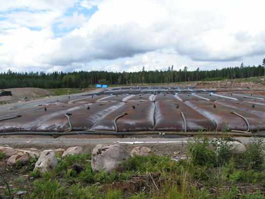
For the first LI@SX of 2012, Studio-X NYC is delighted to welcome Rob Holmes and Stephen Becker of Mammoth and Tim Maly of Quiet Babylon, three-quarters of the Dredge Research Collaborative (with Brett Milligan of Free Association Design), for a short visual tour of hulking geotubes, silt fences, sensate geotextiles, and other monuments of the dredge cycle, followed by a lively Q&A and informal discussion on the unrecognized architectural possibilities of dredge.

While dredge is commonly considered a linear act of industrial engineering — a dredging machine arrives at a site, sucks up a great quantity of sediment, and deposits that sediment on some other site — we argue that dredging is better understood as a component of a wider network of anthropogenic sedimentary processes which generate a fascinating array of interconnected landscapes.  Fluid topographies are restrained by bright orange silt fences; dredging barges continuously empty shipping channels which are promptly re-filled with sediment disturbed by upstream farms and new subdivisions; sensate geotextiles monitor the stability of landscapes they are literally embedded in; hulking geo-tubes lay engorged with dredged sediments in streams on Filipino golf courses and along Mexican beaches and on the coastal dunescape of Virginian spaceports.  Silts, sands, and clays flow rapidly between these landscapes in liquid suspension, linking them and re-shaping the earth’s surface.  Collectively, the choreography of these landscapes embodies a vastly quickened counterpart to conventionally defined geologic cycles — the Dredge Cycle.

The Dredge Cycle is landscape design on a deliriously monumental scale, but unrecognized as an architecture. So far, it remains the domain of logistics, industry, and engineering, a soft successor to the elevated freeway interchanges and massive dams that captured the cultural imagination of the previous century, a new infrastructural vernacular for the self-aware Anthropocene.

At Studio-X, we’ll be talking both about what extant landscapes of dredge are like, and what potentials for design intervention they might offer.  The event, which is on January 24th from 6:30 pm to 8:30 pm, is free and open to the public; Studio-X NYC is 180 Varick Street, Suite 1610.

The evening’s conversation will serve as a prelude to a limited-ticket Festival of Dredge tour this summer, for which LI@SX attendees will be given reservation priority — look for more details on the Festival in the future.

everyday structures

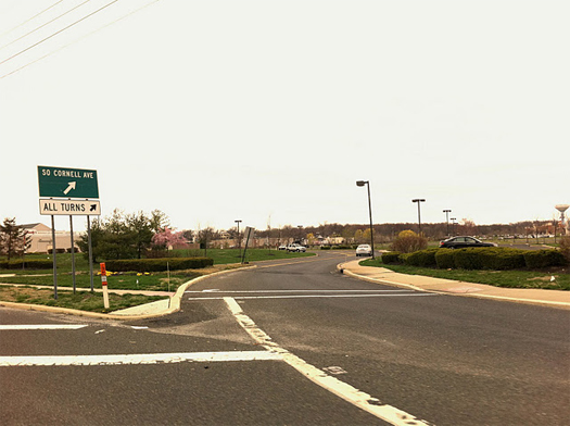
Recommended reading: Alan Wiig’s “everyday structures”, a blog “explor[ing] the place of infrastructure in the urban landscape”, with a particular focus on “Hertzian space” and digital communications infrastructure. Wiig is studying geography at Temple University, so his blog most typically deals with landscapes in Philadelphia or its surrounds. Like many of mammoth‘s favorite things at the moment, “everyday structures” deals with the quotidian material conditions of landscape, posting both readings from Sanford Kwinter or Henri Lefebvre and snapshots of Pelton wheels or a homeless camp juxtaposed with broadband lines. In a recent conversation with a couple other landscape architects, I noted that I think geographers are, in many ways, doing a better job of conceptualizing landscape than landscape architects, particularly with relation to infrastructural conditions in the networked city — Wiig’s blog is an excellent example of that.

[Image at top is from the post “fiber along the road” on “everyday structures”.  Wiig captions — and I quote the full caption because it is the combination of image and caption that makes the typical snapshot on “everyday structures” fascinating — “Automobiles turning, the fiber optic cable runs parallel to the road. Marlton Pike West, in the Garden State. That little white and orange marker in front of the “SO Cornell Ave –>” and “ALL TURNS –>” signs indicates the Internet and other forms of digital communication are flowing alongside the automotive and pedestrian traffic on this route.”]

bracket [at extremes]

Bracket has issued a call for submissions for their third issue, [at extremes]:

Bracket 3 invites the submission of critical articles and unpublished design projects that investigate the potentials when situations extend beyond norms – into the extremities. We are conditioned, as designers of the built environment, towards the organization of people, programs and movement. Indeed the history of modern urbanism, architecture and building science has been predicated on an anti-entropic notion of programmatic and social order. But are there scenarios in which a state of extremity or imbalance is productive?

Ulrick Beck, in “Risk Society’s Cosmopolitan Moment” suggests that being at risk is the human condition at the beginning of the twenty-first century. While risk produces inequality and destabilization, he argues, it can be the catalyst for the construction of new institutions. The term extreme is defined as outermost, utmost, farthest, last or frontier. Bracket [at Extremes] seeks to understand what new spatial orders emerge in this liminal space. How might it be leveraged as an opportunity for invention?  What are the limits of wilderness and control, of the natural and artificial, the real and the virtual? What new landscapes, networks, and urban models might emerge in the wake of destabilized economic, social and environmental conditions?

Bracket [at Extremes] will examine architecture, infrastructure and technology as they operate in conditions of imbalance, negotiate tipping points and test limit states. In such conditions, the status quo is no longer possible; systems must extend performance and accommodate unpredictability. As new protocols emerge, new opportunities present themselves. Bracket [at Extremes] seeks innovative contributions interrogating extreme processes (technologies, operations) and extreme contexts (cultural, climatic). What is the breaking point of architecture at extremes?

The submission deadline is February 20, 2012; more details, including a typically stellar jury, available at the Bracket site.

[Image by Charles Negre, via but does it float.]

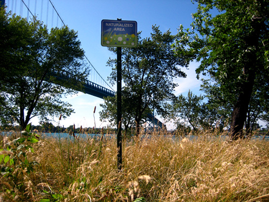
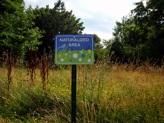
signs for naturalized areas


[“Signs for Naturalized Areas”, from Windsor, Ontario’s Broken City Lab; the signs were installed in the summer of 2009, after a city workers’ strike left various vacant lots unmowed and teeming with accidental plant communities.  The emergent flora were apparently commonly viewed negatively, as a symbol of the political conflict surrounding the workers’ strike; the project aimed to invert that understanding, and suggest that citizens might instead view them as “wonderful additions to [the] urban landscape”.]

“Signs for Naturalized Areas” strike me as particularly interesting in light of my post from last week on “hypothetical signs”, as, like both the Hypothetical Development Organization and Gökçeoğlu’s mayoral campaign, these are also an example of signs-as-(landscape)-architecture.  The difference here, though, is that while both the HDO and Gökçeoğlu’s photoshops used signs as a means for publishing an architectural proposal — a story about how a place might be constructed differently — Broken City Lab used signs to advertise an extant but hitherto invisible quality of the landscape. These signs reveal, rather than inventing. (It is perhaps not a coincidence that the artists working in landscape utilize this mode of operation, while the HDO and Gökçeoğlu, working with buildings, operate in the other.)

dharavi: globalization and spontaneously mixed uses


[The following piece, on the surprising ways that the residents of the Mumbai settlement of Dharavi have integrated that urban agglomeration into global economic networks, and the value of the unique spatial formatting that both enables and results from that integration, is the second thoroughly-footnoted guest post we’ve run from Peter Nunns. (The first was “fecal politics”.) After being on hiatus during the time when we published that first post, Peter is blogging again at Read after Burning.]

“The slum-dwellers,” he adds, “are experts at live-work space design. They spontaneously do mixed-use! We just have to learn from them.” [1]

When homes are also considered places of work – either unpaid housework or paid industrial homework – then the industrial geography of the city assumes new meanings. [2]

1 Mason 2011

2 Sassen 2001: 261

3 Patel and Arputham 2007, Fernando 2009

4 UN 2006: 37

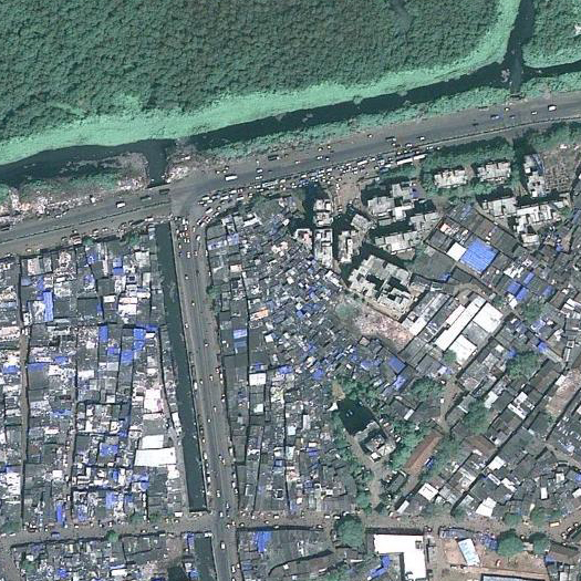
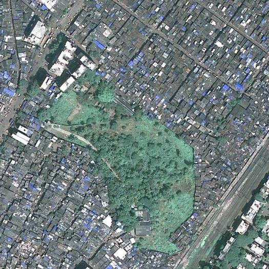
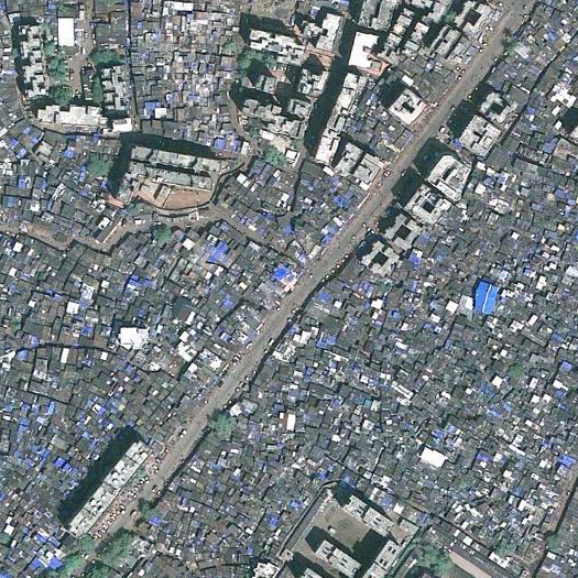
Dharavi has been described as “Asia’s largest slum”. Between 600,000 and 1 million people live in 85 dense neighborhoods clustered on 2.4 square kilometers of low-lying, marshy land in the heart of Mumbai [3]. (Mumbai’s total population was estimated at 18.2 million in 2005 by UNDESA (2010).) It is one of the most overcrowded areas of Mumbai – and one of the worst-served by infrastructure. Dharavi contains an estimated 1,440 people for each toilet seat, meaning that “streets, lacking drainage, become channels for filthy water carrying human excrement” during the rainy season [4]. In many respects, it has become a byword for urban squalor and poverty.

5 Nijman 2009

6 Grant and Nijman 2003: 474

7 Patel 2010

8 Chalana 2010: 31

9 Benjamin 2008: 721

It’s also a chunk of incredibly valuable real estate. The relaxation of foreign investment rules brought an influx of capital into Mumbai in the 1990s, and land prices skyrocketed [5]. The city’s central business district was “the most expensive in the world” in the mid-90s, while “residential real estate prices spiralled up as well, in part in response to the influx of money from nonresident Indians” [6]. Dharavi, which lies between two of the main rail lines, with close access to the new financial district and the international airport [7], has been describes as the “Opportunity of the Millennium” for developers [8]. Remaking Dharavi would open up new territory for foreign direct investment and globally-linked industries that would benefit from proximity to the international airport and CBD. In the words of Solomon Benjamin, it would exorcise the “spectre of cities besieged by cancerous slums” by putting a “modernist spin on attracting economic development: ‘Bangalore transforming into a Singapore, Bombay [Mumbai] into a Shanghai, and Delhi into a London’!” [9]
10 Chalana 2010, Patel and Arputham 2007

11 The anticipated cost of the redevelopment rose to US $3 billion in the wake of the 2008 financial crisis.

12 Patel, Arputham, Burra and Savchuk 2009

The Dharavi Redevelopment Project (DRP), first proposed in 1996 by Mukesh Mehta, an American-trained architect working in Mumbai and started in 2004, is the latest attempt to capitalize upon inflated land values. It is intended to mix slum upgrading with the development of new office space and housing for Mumbai’s upper and middle classes [10]. The $2 billion DRP [11] calls for Dharavi to be divided into five zones, each of which would be designed and constructed by a separate property development firm. Residents who could prove their occupancy prior to 1995 (later extended to 2000) would be offered apartments on the same sites or new locations in exchange for their land [12]. A portion of profits from the sale of newly-constructed housing and commercial space would be used to finance upgraded housing for Dharavi’s low-income residents, while the rest would be returned to the city government and private developers.

13 Sanyal and Bhattacharya 2010, Nijman 2009

The purpose of the DRP is to globalize Mumbai; to create the sorts of “internationally competitive” living spaces and commercial areas required by globally-mobile businesses and workers in the “knowledge economy”. But this program ignores Dharavi’s actually-existing ties to the broader urban and global economies. The slum houses a wide range of informal enterprises that are integrated into globally disaggregated assembly lines through subcontracting arrangements. While we tend to think of slums as a form of low-income housing, Dharavi’s economic role is at least as important. Its living spaces often double as informal and unregulated production spaces – like many slums, it is a “spontaneous” form of mixed-use design [13].

14 Nijman 2009: 10, Fernando 2009

15 Sanyal and Bhattacharya 2010: 163

16 Nijman 2009: 10

17 Patel and Arputham 2007: 505

Roughly 70 to 80 percent of Dharavi’s residents work within the slum – an unusually high ratio compared with many other Indian slums [14]. It contains at least 5,000 industrial enterprises, which produce textiles, pottery and leather, jewellery, food products, and so on and so forth [15]. Its southwest corner “has a major cluster of plastic recycling factories, with some estimates of well over 500 units,” while many streets are “lined with retailing, food stands, kiosks, taxis, small restaurants, some hotels, etc.” [16]. These industries “provide incomes and livelihoods for hundreds of thousands of Mumbai citizens who would otherwise have no employment” [17]. Because they also entail a number of negative externalities – low wages, unsafe conditions, and high levels of air and water pollution – they rely upon the existence of flexible, unregulated space in the city center.
18 Fernando 2009

19 Sanyal and Bhattacharya 2010: 163

20 Harriss-White 2010: 131

Work done in Dharavi is a crucial part of the city’s economy [18]. Patel and Arputham observe that it “probably contributes far more to the Indian economy than most special economic zones.” Its annual turnover has been estimated at between $700 million and $1 billion [19]. And while Dharavi is somewhat unusual in the magnitude and diversity of its industries, it is part of a wider trend in India’s globalizing economy. According to Sudarshan et al, 30 to 40 percent of India’s exports now originate in the informal economy, which “includes entire industrial clusters making goods for export (metalware, machine tools, leatherware, textiles and garments, tools and equipment, and some IT services)” [20]. The expansion of India’s international trade is related to the growth of subcontracting networks and industrial homework.

21 Harriss-White and Sinha 2007, see also Frenkel and Kuruvilla 2002

22 Sudarshan et al 2007: 179

Over the past two decades, the country’s manufacturing sector has undergone parallel processes of upgrading and downgrading: businesses in the formal sector have become more capital intensive, displacing labor-intensive work into the decentralized and more flexible informal sector [21]. According to Sanyal and Bhattacharya, “sub-contracting from large firms to small firms has been increasing and consequently numbers of homeworkers, to whom small firms in turn sub-contract, are also increasing” (see also UNIFEM 2000). In 1999/2000, there were approximately 28 million homeworkers in the non-agricultural labor force, 30 percent of whom were located in urban areas [22]. The bottom reaches of subcontracting networks are predominantly female. Rani and Unni found that in 2000/01, “home-based [production] workers constituted about 81 percent of all female workers and about 46 percent of male workers.”

23 Sanyal and Bhattacharya 2010: 163

As the case of Dharavi demonstrates, these production arrangements also rely upon certain spatial arrangements. Slums are often ideal locations for combining living and work space – a fact that is often not appreciated by redevelopment projects. Consequently, the DRP is doubly problematic for residents: it threatens both their shelter and their livelihoods. Many of the central issues of contention relate to the preservation of Dharavi’s informal industries and mixed-use spaces. As a result, “the Dharavi resistance qualifies more as a ‘labour’ mobilization than slum dwellers’ resistance” [23].

24 Chalana 2010: 31

25 Chalana 2010: 32

The current master plan “entails building the rehabilitation housing zones on less than half of the original land, and allocating only 2 percent of the land to retain ‘‘non-polluting’’ industries” [24]. On the one hand, this would either increase density to an unsustainable level, or displace many of Dharavi’s residents. The project “would likely create additional homelessness, as some estimates suggest that about a quarter of the existing residents would not be eligible for rehabilitation based on the residency requirement,” which provides for resettlement only for households that can prove residency prior to 2000 [25].
26 Sanyal and Bhattacharya 2010: 163

On the other, the DRP proposes to replace existing shelters, which often mix domestic and industrial uses, with small residential spaces in high-rise buildings. As a consequence, the “entire business district as Dharavi is under threat because most of the enterprises do not have licences and so cannot find any place in the new redeveloped Dharavi [26]. Although “non-hazardous and non-polluting” workshops can potentially be rehoused, this will still mean closure of several important industries, such as pottery, leather goods, and recycling, and the loss (or displacement to the urban periphery) of tens or hundreds of thousands of jobs.

27 Patel and Arputham 2007, 2008, Patel, Arputham, Burra and Savchuk 2009, Arputham and Patel 2010

Two community organizations have contested the DRP, moving it into a “zone of negotiation” between inhabitants and city government. In a series of articles published in the academic journal Environment and Urbanization, the leaders of the Alliance have provided regular updates on political negotiations over the project [27].

28 Patel, Arputham, Burra and Savchuk 2009: 244

29 Patel, Arputham, Burra and Savchuk 2009, Chalana 2010

30 Patel, Arputham, Burra and Savchuk 2009: 244

31 Arputham and Patel 2010: 502

To date, residents’ activism has secured several important gains. First, proposed densities have been lowered significantly. New guidelines issued in October 2008 specified a maximum building height of eight or ten stories, as opposed to original plans for 20 to 30 story apartment buildings [28]. The size of rehabilitation apartments for eligible slum-dwellers has also been increased, from 225 square feet to between 250 and 300 square feet [29]. This will, of course, make them more livable – but it will also provide additional space for home-based industries. Likewise, there have been incremental improvements to the space available for work in Dharavi. The original plans called for 50 percent of the floor space offered for sale by developers to be used for upper/middle-class housing [30]. Guidelines released in 2008 specify that 80 percent be available for commercial use – although there are wide variations between the five proposed sectors [31].

The fate of Dharavi is likely to set a precedent for future slum redevelopment projects in India. Activists and developers are closely watching the case of Dharavi: if such a large, economically important space can be redeveloped without significant consultation with residents, it will open the door for similar efforts elsewhere. In their latest update, Arputham and Patel note that the DRP is already being considered as a model for the redevelopment of a 1.1 square kilometre slum adjoining the Mumbai International Airport, which currently houses 85,000 or more households on commercially-valuable land.

I suppose that I’m alluding to two different types of outcome here. The first is a social one – the DRP would make many current Dharavi residents worse off, or at any rate reduce their ability to make choices about the city in which they live. But leaving that aside (and it’s a large thing to set aside!), the DRP may be a flawed project even on purely macroeconomic terms. It’s an attempt to develop Mumbai as a global city that completely runs roughshod over the actually-existing globalization occurring there. In a sense, it’s a struggle over whether a type of informal mixed-use design, and a certain mode of global integration, is allowed to continue within Mumbai.

[On the topic of the DRP, this old Airoots post, which makes a similar argument for understanding Dharavi as a “self-generating post-industrial city”, is also worth a read:

The inhabitants of Dharavi have a fantastic capacity to solve their own problems. For many, Dharavi has been a platform for social mobility to middle-classdoom. However, one problem the inhabitants cannot get their head around is the threat of a top down redevelopment plan backed by the state. This burdens the residents of Dharavi more than anything else. Not only does the state not help, it even comes in the way of self-development. Why would anyone invest in their homes or business if it risks being bulldozed in a few months or years?

What seems to separate Dharavi from the DRP more than anything else is a generational gap. In the age of user-generated content, open-source and P2P, the net generation connects intuitively with the archetype of the squatter, who, just like the hacker in another realm, delves in and strives to overcome loopholes leftover by the system, and uses community and social networking as its modus operandi. In fact, it makes total sense to understand Dharavi as a self-generating post-industrial city…

More than a master plan, Dharavi needs a liberation of the imagination. Lets drop the heavy CAD maps and GIS surveys and zoom in to the street level. All Dharavi needs is some creative photoshoping and less of a patronising colonial gaze. If allowed to develop through their own internal skills, if provided for with basic infrastructural and amenities, the hundreds of enclaves, will keep improving their conditions, as they have always done. While no one can imagine what the neighbourhood may look in a couple of decades, it is certain to represent the city’s spirit like nothing else.

Click through for the references for Peter’s post.]

Read More »
hypothethical signs


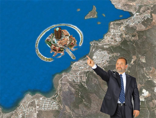
[An image from Mehmet Ali Gökçeoğlu’s mayoral campaign.]

This past summer on Places, Rob Walker, one of the artists behind the “Hypothetical Development Organization”, penned a brief history of architecture fiction and discussed the even-briefer history of that organization.  (The Hypothetical Development Organization was, if you are unfamiliar with it, a brief initiative which produced “hypothetical futures” for each of ten selected sites in New Orleans, with the proposals unbound “by rules relating to commercial potential, practical materials, or physics”.)  My favorite thing that Walker does in the essay is tracing the essential vein of weirdness that links the fiction produced by the Hypothetical Development Organization to the ordinary and common development signs that inspired the project:

“One day I went for a routine walk. My wife and I live in Savannah, GA, in an area that’s mostly residential, but interspersed with commercial and public buildings. It’s a nice stroll to an excellent bakery, my bank, a convenience store, the main branch of the public library.

Our neighborhood is the sort that people describe as “transitional,” and some of the property, both residential and commercial, is vacant. On one nearby commercial structure, vacant for the four-plus years we’ve lived in the area, I noticed a sign during this particular walk. You’ve seen similar signs, and I’d seen this one probably a hundred times, without ever really thinking about it. It was a rendering of a development, a future, involving a small, empty building. It suddenly struck me that, given how long this sign has been here, what it depicted was, at best, a hypothetical future — and arguably a fictitious one.

Since whenever this sign was first posted, the real estate market has collapsed, the old go-go economy has evaporated, and as it happens this building has been put up for sale. Any development that may take place some day would depend on someone buying it, and on what that party might want to do. Until then, it’s just another empty building that happens to have a sign on it. The disparity between the rendering and reality is considerable: In the rendering, in fact, the actual extant structure has been folded into a much bigger building, which in point of fact exists nowhere besides that rendering. In real life, it’s a vacant lot.

It further struck me that there are vacant buildings much like this one, with no definitive future, all over town — all over lots of towns. In a sense, then, our city streets are full of fiction, or something very much like it. The stories, mostly visual, are told in the form of colorful signs attached to drab or neglected structures, presenting speculations about how the very same physical place might look in some unspecified future. The abandoned office tower could house airy condos. The long-shuttered auto shop might morph into a gleaming boutique. The factory built for some bankrupt enterprise will, perhaps, burst with life again, its cheery mixed uses enjoyed by stock-image people representing a cross-section of pleasant citizenry. Sometimes these ideas are punctuated by the name of a development company and its Web address. But the story flows mostly from the beguiling picture, showing what could hypothetically happen, right here.”

This seems both fantastic — recognizing the strangeness of ordinary things examined closely — and exactly right to me — recognizing the fundamental similarity in genre between Archigram and Forest City, regardless of the massive differences in how they work within that genre.

It also reminds me of the story of the Turkish real estate agent Mehmet Ali Gökçeoğlu, who we read about in Emre Alturk’s contribution to Al Manakh 2, “Dubai, Copied and Pasted”.  You might say that, like Walker, Gökçeoğlu recognized something of the unrealized potential of the development sign as a fiction.  And, also like the story of the Hypothetical Development Organization, Gökçeoğlu’s story indicates the power of telling stories not as “a series of words”, but through “plans, schematics, models, renderings”.

Unlike Walker, though, Gökçeoğlu was not satisfied to let his pictures simply tell a story.  He ran for office on them:

“In January 2009, Mehmet Ali Gökçeoğlu, a local real estate agent running for mayor of Cesme, Turkey, publicized his campaign throughout the town in billboards and pamphlets.  His vision for the future of this Izmir borough was to make it the Dubai of Turkey, literally.  The imagery he deployed constituted aerial pictures of this touristic peninsula, fashioned with many projects previously proposed for Dubai including; an identical replica of the Palm Island, along with a tower of independently rotating floors to be the tallest in the world; a yacht marina, similarly to be the largest in the world; and an UFO shaped restaurant hovering meters above the ground.  It wasn’t long before the ‘most eccentric campaign of the elections’, as it was called by the media, made it to the national newspapers accompanied with snide remarks.  The imagery of the campaign circulated via email for weeks.  Eventually Gökçeoğlu wasn’t even close to securing the candidate post in his party — the ruling Justice and Development Party.  Enjoying a brief media attention, the campaign lived a short life in the absence of an endorsing sheik, money, public support, legislative basis and tax policies to attract desired foreign investment, or any substantial program for that matter.

There is hardly much to take seriously about the campaign.  But, wildly unfounded as it is, it does bring two things to mind.  First of all, it is striking that it caught a wide public attention at all.  Gökçeoğlu’s vision would have hardly found any audience beyond the small crowd that he is probably able to gather in a political rally, if it weren’t for the images.  It took him a — probably cracked — copy of Photoshop, some images pulled off the net, some hours of labor, and a modest capital to render this speculative agenda visible and palpable, thus mobilizing more attention and reaction…”

[Also on Places, the second installment in Mimi Zeiger’s “The Interventionist’s Toolkit” looked at the Hypothetical Development Organization as one of a series of “posters, pamphlets, and guides” occupying one niche in the world of “Provisional, Opportunistic, Ubiquitous, and Odd Tactics in Guerilla and DIY Practice and Urbanism”.  (This niche is not unrelated to the nascent genre of the urban field manual.)  In BLDGBLOG post entitled “Urban Hypotheticals”, Geoff Manaugh both describes the Hypothetical Development Organization and discusses more generally the potential uses and abuses of such speculative architectural projects.]

the network as industry


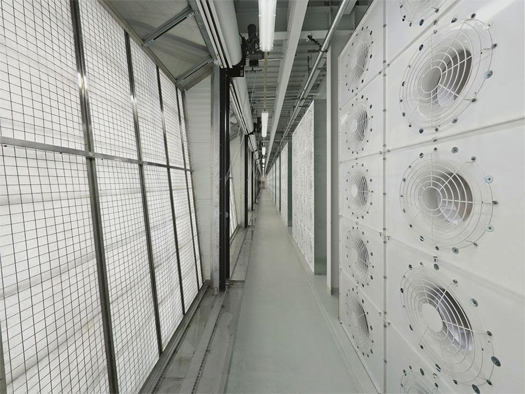
[“Interior components of the cooling system” at a Facebook data center in Palo Alto; image via Alexis Madrigal’s report for Domus on Facebook’s Open Computer Project, which “describes in detail how to construct an energy-efficient data centre”.]

“Secret Servers”, an article by James Bridle originally published in issue 099 of Icon magazine, looks at the relationship between architecture and the physical infrastructure of the internet. I found Bridle’s last few paragraphs particularly provocative:

“What is at stake is the way in which architects help to define and shape the image of the network to the general public. Datacenters are the outward embodiment of a huge range of public and private services, from banking to electronic voting, government bureaucracy to social networks. As such, they stand as a new form of civic architecture, at odds with their historical desire for anonymity.

Facebook’s largest facility is its new datacenter in Prineville, Oregon, tapping into the same cheap electricity which powers Google’s project in The Dalles. The social network of more than 600 million users is instantiated as a 307,000 square foot site currently employing over 1,000 construction workers—which will dwindle to just 35 jobs when operational. But in addition to the $110,000 a year Facebook has promised to local civic funds, and a franchise fee for power sold by the city, comes a new definition for datacenters and their workers, articulated by site manager Ken Patchett: “We’re the blue collar guys of the tech industry, and we’re really proud of that. This is a factory. It’s just a different kind of factory then you might be used to. It’s not a sawmill or a plywood mill, but it’s a factory nonetheless.”

This sentiment is echoed in McDonald’s description of “a new age industrial architecture”, of cities re-industrialised rather than trying to become “cultural cities”, a modern Milan emphasising the value of engineering and the craft and “making” inherent in information technology and digital real estate.

The role of the architect in the new digital real estate is to work at different levels, in Macdonald’s words “from planning and building design right down to cultural integration with other activities.” The cloud, the network, the “new heavy industry”, is reshaping the physical landscape, from the reconfiguration of Lower Manhattan to provide low-latency access to the New York Stock Exchange, to the tangles of transatlantic fiber cables coming ashore at Widemouth Bay, an old smuggler’s haunt on the Cornish coast. A formerly stealth sector is coming out into the open, revealing a tension between historical discretion and corporate projection, and bringing with it the opportunity to define a new architectural vocabulary for the digitised world.”

Though Bridle does not make this link explicit in the article, the idea of a potential “new architectural vocabulary” is clearly related to the “New Aesthetic” that Bridle began talking about this past May.  (I’ve always liked Matt Berg’s description of it as a “sensor vernacular”, and Robin Sloan’s “digital backwash aesthetic”.  I’m not sure either of those capture exactly what Bridle’s been talking about — more like pieces of it — but they all dance around the same set of things, or at least similar sets.)  Here’s Bridle’s original description, pinched together:

For so long we’ve stared up at space in wonder, but with cheap satellite imagery and cameras on kites and RC helicopters, we’re looking at the ground with new eyes, to see structures and infrastructures.

The map fragments, visible at different resolutions, accepting of differing hierarchies of objects.

Views of the landscape are superimposed on one another. Time itself dilates.

Representations of people and of technology begin to break down, to come apart not at the seams, but at the pixels.

The rough, pixelated, low-resolution edges of the screen are becoming in the world.

And when that — a new aesthetic vocabulary — gets linked to a “re-industrialization”, pulling together aesthetics, culture, economics, and politics, you’ve got a pretty significant project.  I’d like to talk about this at more length later, but for now I will just quote from Dan Hill’s fantastic 14 Cities project.  (Independent of the concerns in this post, the whole project is worth a read.)  This is the fourth of the fourteen fictional future cities Hill describes, “Re-industrial City”:

“The advances in various light manufacturing technologies throughout the early part of the 21st century — rapid prototyping, 3D printing and various local clean energy sources — enabled a return of industry to the city. Noise, pollution and other externalities were so low as to be insignificant, and allied to the nascent interest in digitally-enabled craft at the turn of the century, by the early 2020s suburbs had become light industrial zones once again.

Waterloo, Alexandria and the Inner West of Sydney through to Pyrmont once again became a thriving manufacturing centre, albeit on a domestic scale, as people were able to ‘micro-manufacture’ products from their backyard, or send designs to mass-manufacture hubs supported by logistics networks of electric delivery vans and trains. Melbourne had led the way through its nurturing of production in the creative industries and its existing built fabric.

In an ironic twist, former warehouses and factories are being partially converted from apartments back into warehouses and factories. Yet the domestic scale of the technologies means they can coexist with living spaces, actually suggesting a return to the craftsman’s studio model of the Middle Ages. The ‘faber’ movement — faber, to make — spread through most Australian cities, with the ‘re-industrial city’ as the result, a genuinely mixed-use productive place — with an identity.”

[For more on the New Aesthetic, read Rob Walker’s recent interview with James Bridle at Design Observer.  It’s also well-worth checking out the essay in Domus by Alexis Madrigal that the image at top is taken from.]

cellular confinement


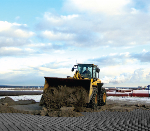
[Cellular confinement systems were originally developed by the Army Corps of Engineers to facilitate the quick construction of temporary roads for heavy military vehicles; photograph from a Neoloy brochure.]

In a remote polar region, there is a small country that is rarely visited by outsiders.  On the advice of a rogue Army Corps of Engineers liason — who was attached to the American embassy there in the mid-seventies and forgotten when the embassy was closed a decade later, but who, through his close relationship with the country’s ruling party, has become the country’s Minister of Internal Improvements — all of the nation’s roads are constructed using built-to-fail cellular confinement systems.  What this means, of course, is that the nation’s roads are completely ephemeral, constantly appearing, disappearing, and re-appearing in response to the whims of commerce, the dictates of the Ministry, or even the happy mistakes of mis-directed or confused systems crews.  You drive in to lead a medical clinic, and two years later, when you go to leave, the road you came in on has disappeared.  Or zags northwest instead of northeast.

Maps of the nation’s roads are thus out of date as quickly as they are drawn, though it should be noted that clever cartographers have taken to color-coding the lines for roads based on their expected date of expiration.

low roads and architecture


[Building 20 at MIT, a “250,000-square foot wood building [that] hosted the development of many important research disciplines from Chomskyan linguistics to the new style of computing promoted by early hackers”.]

1. Alexis Madrigal writes about “Low Road” buildings:

…startup lore says that many companies were founded in garages, attics, and warehouses. Once word got around, companies started copying the formula. They stuck stylized cube farms into faux warehouses and figured that would work. The coolness of these operations would help them look cool and retain employees. Keep scaling that idea up and you get Apple’s ultrahip mega headquarters, which is part spaceship and part Apple Store.

But as Stewart Brand argued in his pathbreaking essay, “‘Nobody Cares What You Do in There’: The Low Road,” it’s not hip buildings that foster creativity but crappy ones.

“Low Road buildings are low-visibility, low-rent, no-style, high-turnover,” Brand wrote. “Most of the world’s work is done in Low Road buildings, and even in rich societies the most inventive creativity, especially youthful creativity, will be found in Low Road buildings taking full advantage of the license to try things.”

Brand’s essay originally appeared in his book, How Buildings Learn, and has just been re-released as part of The Innovator’s Cookbook, a new Steven Johnson-edited tome of great essays about inventing stuff. It couldn’t come at a better time. The aesthetic of innovation now dominates the startup scene, but it’s like the skeleton of a long-dead invention beast. The point of a Low Road building isn’t that it looks any particular way but rather that you could do anything with and in them. “It has to do with freedom,” as Brand put it.

While Madrigal is writing for the Atlantic‘s Technology channel, and is consequently concerned with Low Road buildings as the places in which technological innovation happens, the thing that interests me here is what the Low Road building says about architecture. That is,  if Building 20 is where innovation happens, but Apple’s megaheadquarters are where architects get involved, then is architecture’s relationship to innovation merely that architects get involved with an organization after it has lost the capacity to innovate? Is architecture’s relationship with innovative organizations primarily that it instantiates their ossification?

2. Or is there a role for architects to play in the spatial structuring of innovative and vibrant organizations? If so, what does this architecture look like? Madrigal and Brand suggest that, whatever this architecture might be, it certainly doesn’t look like Norman Foster and Frank Gehry — whatever the merits of their work may be.

Dan Hill speculates about such an architecture in an old City of Sound post:

“Brand uses this point about the endless productivity of these old spaces to reinforce one of Jane Jacobs: that new ideas generally can’t come from new buildings (The Death and Life of Great American Cities). However, if the Smithsons had attempted to design Sheffield University – a defiantly new building – with the characteristics Brand was looking for in old buildings, perhaps the situation is more subtle than Brand and Jacobs suggest? One hopes so, as much as it makes good sense to reuse suitable old built environment. There are strong ideas in Gehry’s building, in terms of creating ‘trading zones’ forcing disciplines together (more on this theme in a forthcoming entry on Richard MacCormac’s new Broadcasting House building) and it’s important to resist forgoing innovation and modernity in such buildings in favour of simply lobbing up portakabins for the sake of ongoing adaptability. Adaptability and modernity surely needn’t be mutually exclusive.”

(Another City of Sound post from the same time period discusses the Smithson’s work at Sheffield University.)

3. Commenting on Madrigal’s piece, Bill Woods adds a quote from C. Northcote Parkinson’s Parkinson’s Law:

It is now known that a perfection of planned layout is achieved only by institutions on the point of collapse. This apparently paradoxical conclusion is based upon a wealth of archaeological and historical research, … A study and comparison of these [buildings] has tended to prove that perfection of planning is a symptom of decay. During a period of exciting discovery or progress there is no time to plan the perfect headquarters. The time for that comes later, when all the important work has been done. Perfection, we know, is finality; and finality is death.

Satirical or not, it seems that there is a useful lesson for architects in this, as it would be terrifically sad if we defined architecture so that great architecture is possible only in an era of decay.

4. Finally, I’m reminded of a comment that Bryan Boyer made in an extended discussion at Rory Hyde’s blog at the beginning of the year. Boyer described his thesis work (which proposed a new capitol for the United States) as being an investigation into “the organizational consequences of spatial decisions made without any spatial understanding”. It seems to me that, if there is a role for architects to play in the life of organizations or institutions which find themselves in “a period of exciting discovery or progress”, it will almost certainly involve understanding the organizational consequences of spatial decisions — and being able to demonstrate convincingly that architects bring a kind of understanding to those decisions that will improve them as they are made.