mammoth // building nothing out of something

the collision of geologic time and infrastructural control

“Before artificial levee construction, the river avulsed and a new delta was constructed every 1,000-1,500 yr: the active Plaquemines-Balize Delta began to form about 1,000 yr ago, and was for some time contemporaneous with the older Lafourche Delta, whereas diversion to the Atchafalaya River course began about 500 yr ago, but is now managed by the US Army Corps of Engineers.”

[Michael Blum and Harry Roberts, “Drowning of the Mississippi Delta due to insufficient sediment supply and global sea-level rise”; PDF link]

hyper-reality: a new vision of the future

Long-time readers of mammoth may recall our excitement at Keiichi Matsuda’s short films Domestic Robocop and Augmented City, both of which present believable near-future visions of a world in which “synthetic spaces created by the digital information that we collect, consume and organise” supersede “the physical space of buildings and landscape”, while at the same time subtly critiquing the potentially dystopian character of this future.

Matsuda recently launched a Kickstarter to fund the production of a new set of films set in a similar future, swapping out London for Medellin. (I mention that swap because I think it’s a fantastic choice, given the socioeconomic, cultural, and architectural environment of Medellin.) Based on his earlier work, I think we can trust Matsuda when he says that “it will be an ambitious new vision of the future; instead of jetpacks, flying cars and robots, think smart cities, super-social media, and ubiquitous augmented reality. It will be a science fiction short for our time; introspective, critical, and beautifully designed.”

But if you won’t take my word for it, check out Matsuda’s launch video:

We don’t post many requests for funding on mammoth, but we highly encourage you to contribute (as we have) to Matsuda’s project, which has roughly a week left to obtain full funding. (The final deadline is Saturday, December 7.)

dredgefest louisiana

525_sediment delta

Things have been terribly quiet here at mammoth this fall. (Assuming that by “here” we mean “here, on the blog”; they’ve been quite busy if by “here” we mean “here in Ohio and Virginia”, which is where I’ve physically been. Hopefully I’ll get a chance to recap those adventures soon — there’s been quite a bit to write about.) One of the biggest reasons for that quietness is the enormous amount of planning and energy that’s gone into putting together DredgeFest Louisiana, which we’re very excited to now be able to publicly announce.

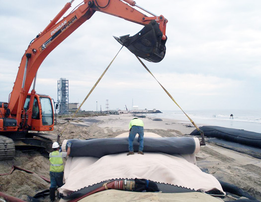
DredgeFest Louisiana is a symposiumfield expedition, and speculative design workshop about the human manipulation of sediments, from the infrastructural constraint of the Mississippi River at a continental scale to bright orange erosion control fences bulging with wet mud in a spring downpour on a suburban construction site. It is an encounter between government agencies, designers, theorists, academics, corporate practitioners, industry experts, students, and the public. It’ll be a lot like DredgeFest NYC, but with the emphasis on a lot: bigger, longer, more speculative, more intense. Much like the Mississippi River itself.

It will run January 11-17, 2014: a full week, though the individual components are two days (symposium), one day (tour), and four days (workshops).

It will move between New Orleans and Baton Rouge. The symposium, which opens the event, is in New Orleans. The workshops will be hosted by the Robert Reich School of Landscape Architecture in Baton Rouge. The tour, which closes out DredgeFest Louisiana on January 17, will depart from and return to New Orleans.

Perhaps most importantly: tickets for DredgeFest Louisiana are available through Brown Paper Tickets, at dredgefestlouisiana.brownpapertickets.com. For the rest of November, tickets are available at an early-bird discount of 25% off. (You’ll see, if you click over to Brown Paper Tickets, that ticket prices are rather low, at least relative to similar events. This is because DredgeFest is a non-profit event — a labor of love — and we want to make DredgeFest open to as many people as possible. That said, space is limited, particularly for the workshops, so better to reserve tickets sooner rather than later.)

Read on for much more detail about the event theme and components.
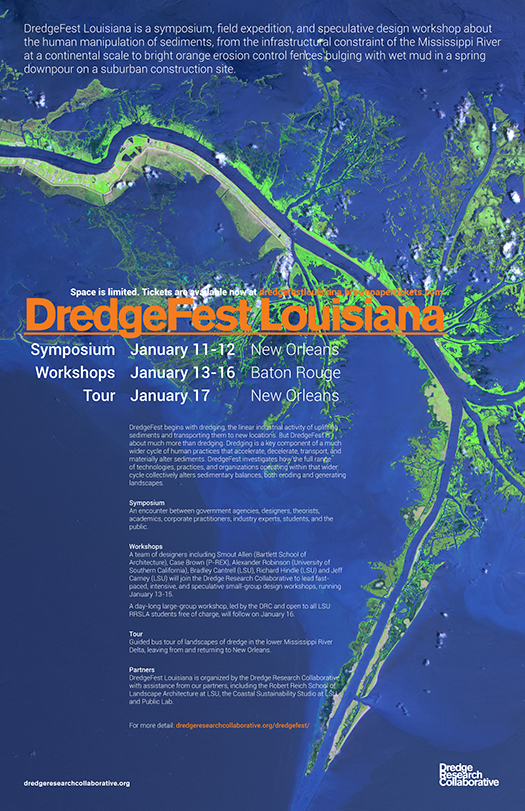
525_DredgeFest Louisiana_Poster_11x17

Terrain
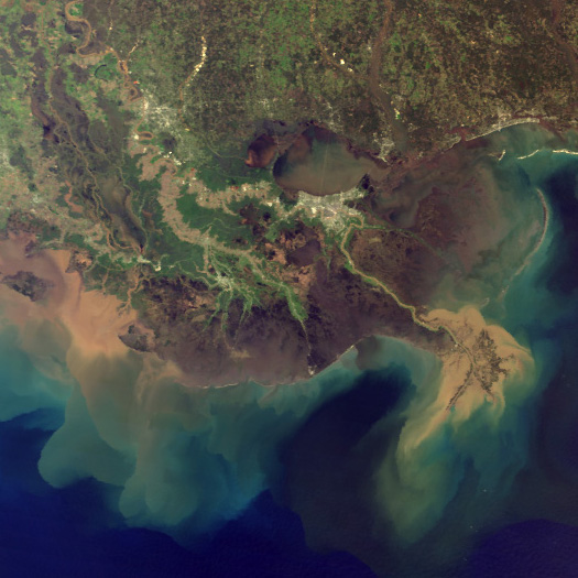
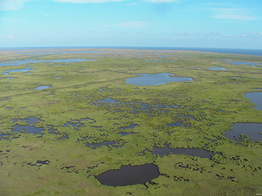
Geographer Richard Campanella has evocatively described the Mississippi River—which is North America’s largest river, discharging more than three times as much water as the next largest river in the United States—as the “land-making machine”. And, indeed, historically, this is what the Mississippi River did: it made land, building its enormous delta—the southern half of the state of Louisiana—over the course of a mere five thousand years, carrying approximately 400 million tons of sediment out of the center of the continent every year, and spraying that sediment around the edges of its mouth. Even today, constrained by levees reinforced with articulated concrete mattresses, locked into a single course at Old River Control, and starved of sediment by upstream dams, the Mississippi River retains potent land-making power, readily evidenced, for instance, by the growth of the Wax Lake Delta, a new delta southwest of New Orleans formed as a by-product of the reorganization of river flows for navigation and flood control. Nearly 200 million tons of sediment still flow every year down the Mississippi and its primary branch, the Atchafalaya.

At the same time, south Louisiana is shrinking. Sea-level rise, salt water intrusion, canal excavation for industrial purposes, and flood control along the edge of the Mississippi River have altered the balance between deposition, subsidence, and erosion. As a consequence, Louisiana has lost over 1700 square miles of land (an area greater than the state of Rhode Island) since 1930, and, without a change in course, is anticipated to double that loss in the next fifty years. Settlements from Lake Charles to Bayou LaFourche to New Orleans are endangered by this loss, both directly—as the land itself disappears—and indirectly, as the loss of barrier islands and coastal marshes exposes settlements to storm surge, while heralding the loss of the terrain that extractive industries, from oysters to oil, depend upon for harvesting resources.

This is the terrain that DredgeFest Louisiana enters into.
SANYO DIGITAL CAMERA

Topics
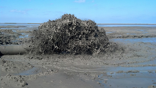
DredgeFest begins with dredging, the linear industrial activity of uplifting sediments and transporting them to new locations. But DredgeFest is about much more than dredging. We believe that dredging is a key component of a much wider cycle of human practices that accelerate, decelerate, transport, and materially alter sediments. We are interested in how the full range of technologies, practices, and organizations operating within that wider cycle collectively alters sedimentary balances, both eroding and generating landscapes.

DredgeFest will investigate topics such as dredging methods, sea-level rise, the beneficial uses of dredged material, habitat restoration, marsh terracing, land loss, barrier island reconstruction, invasive species, revetments, spillways, floods, hurricanes, river flow models, advanced geotextiles, landscape robotics, novel ecosystems, feedback cycles, and turbidity curtains. We are curious about the instruments of public participation within the dredge cycle: grassroots organizations, volunteer efforts, environmental health and justice, the political economy of dredge. We are interested in the choreography of sediment along the length of the Mississippi, from Corn Belt farms to the Gulf of Mexico.

Sediment is foundational to Louisiana, playing a more obviously active role in the lives of Louisianans than in the lives of any other American state. We’re excited to hold DredgeFest in Louisiana because we believe Louisiana is living in the future: experiencing the aggregate consequences of human activities for coastal regions sooner and faster than perhaps any other part of the nation, and experimenting with the tools, methods, and practices that will be required to cope with those consequences. We think that more people should be aware of these things, so we are putting on a festival, open to the public.
525_2013-02-14_13-25-12_744

Schedule
Saturday, January 11-Sunday, January 12
Symposium (New Orleans)

Like the symposium at our previous event, DredgeFest NYC, the symposium at DredgeFest Louisiana will bring together a broad mix of disciplines, corporations, public agencies and organizations in live public conversation, exploring and explaining dredge.

Confirmed symposium participants include:
Sean Burkholder, Assistant Professor of Architecture, University at Buffalo
Travis K. Bost
, architectural designer and independent researcher
Richard Campanella, Geographer and Senior Professor of Practice, Tulane University
Bradley Cantrell, Associate Professor and Director of the Robert Reich School of Landscape Architecture, Louisiana State University
Sarah Cowles, Assistant Professor of Landscape Architecture, The Ohio State University
Andrea Galinski, Strategic Planning, Coastal Protection and Restoration Authority
Stephen Hall, Associate Professor of Biological and Agricultural Engineering, Louisiana State University
Justine Holzman, Lecturer in Landscape Architecture, Louisiana State University
Kees Lokman, Assistant Professor of Landscape Architecture, Washington University in St. Louis
Andy Nyman
, Professor of Wetland Wildlife Ecology, Louisiana State University
Susan Testroet-Bergeron, Public Outreach Coordinator, Coastal Wetlands Planning, Protection and Restoration Act
Eugene Turner, Distinguished Research Master and Shell Endowed Chair in Oceanography and Wetlands Studies, Louisiana State University
Robert Twilley, Professor and Executive Director, Louisiana Sea Grant
Karen Westphal, National Audubon Society Louisiana Coastal Initiative and the Paul J Rainey Wildlife Refuge
Clint Willson
, Director of Engineering Design and Innovation, the Water Institute of the Gulf

The symposium will be accompanied by an exhibition of research on sedimentary landscapes in South Louisiana conducted by the Coastal Sustainability Studio, Public Lab, and the Dredge Research Collaborative, along with additional work by other independent researchers. It will also be followed by an advance screening of “The Fluid and the Solid”, a documentary film by Ben Mendelsohn and Alex Chohlas-Wood about dredging, the Anthropocene, and the exponential rise of human earth moving.

Monday, January 13-Thursday, January 16
Workshops (Baton Rouge)

Internationally-renowned designers including Smout Allen (Bartlett School of Architecture), Case Brown (P-REX), Alexander Robinson (University of Southern California), Bradley Cantrell (LSU), Richard Hindle (LSU) and Jeff Carney (LSU) will join the Dredge Research Collaborative to lead fast-paced, intensive, and speculative small-group design workshops, running January 13-15. Collectively, the workshops are arranged under the theme of “Dredge Futurism” — future scenarios related to the dredge cycle that may lie outside the investigative scope of official predictive procedures. Three detailed tracks — “Adaptive Devices”, “Hybrid Landscapes”, and “Regional Choreography” — will explore distinctive takes on that dredge futurism. (Full descriptions of the track themes can be found at the DredgeFest website.)

A day-long large-group workshop, led by the DRC and open to all LSU landscape architecture students free of charge, will follow on January 16.

Friday, January 17
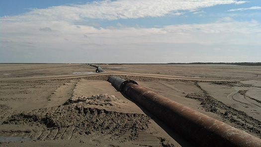
Tour (New Orleans)

This bus tour of dredge landscapes in the lower Mississippi River Delta, leaving from New Orleans, will be ticketed, open to the general public, and led by the Dredge Research Collaborative with local experts.
525_2013-02-14_13-03-55_303

Partners
DredgeFest Louisiana is organized by the Dredge Research Collaborative with assistance from our partners, including the Robert Reich School of Landscape Architecture at Louisiana State University, the Coastal Sustainability Studio at Louisiana State University, and Gulf Coast Public Lab.

Series
DredgeFest is a roving event series. The first DredgeFest was held in New York City on September 28 and 29, 2012. DredgeFest NYC was organized in partnership with Studio-X NYC, an arm of Columbia University’s Graduate School of Architecture, Planning, and Preservation; sponsored by Arcadis, TenCate, and TWFM Ferry; and featured speakers and content from agencies including the US Army Corps of Engineers, National Park Service, Environmental Protection Agency, and New York City Economic Development Corporation. The event was covered in The Atlantic MonthlyWired DesignUrban Omnibus,Dredging TodayScenario JournalLandscape Architecture Frontiers China, and Landscape Architecture Magazine. A full description and video archive of the event can be found here.

finance fundamentals i

Mammoth has long held an interest in the broad social, economic, and logistical systems which provide the context within which any infrastructure, landscape, or building is designed and constructed. One particularly important contextual component is the nature of a project’s financing. This is true for the Panama Canal Expansion, it is true for the Fresh Kills Landfill transformation, and it was true for building the Seattle Public Library. It is true for every new Starbucks, and the suburban freeway extensions which instigate their construction. The environment you are sitting in right now, reading this post, was almost certainly facilitated in part by someone with a background in finance.

Unfortunately, in my experience, finance (and money generally) has been a particularly inscrutable topic for designers. At best, it’s just not something we’ve taken the time to learn with any sort of rigor; at worst, an explicit focus on money, profitability, and financial value is considered to be taboo in the design professions.

Lacking basic financial literacy is harmful to the design professions, especially now, when profit margins are slim and the value designers bring is being called into question. How can we defend the value of our profession when we’re barely able to define ‘value’ in the first place? We’re bringing renderings to a gun fight. Beyond self-justification, understanding the financial constraints and opportunities for each specific project will help improve the chances for outstanding architecture by allowing architects to better leverage our position at the nexus of the project team.

I’m sure, by now, you’ve heard all these arguments before. After all, SHoP built the Porter House, one of the first projects to wear a design-develop model of architectural practice on its sleeve, nearly a decade ago. The past few years of Great Recession have seen calls for increased architectural agency (the most common buzzword for intervening more explicitly in politics, finance, technological development, community outreach, etc.) accelerate even more. And firms like Alloy are creating highly successful projects while breaking new ground by vertically integrating design, development, and construction practices within a studio environment.

So let’s say you buy it. It’s time to learn more about finance. Well, what does that mean?

Most of the time, it’s discussed in vague principles about accepting increased risk — financial, liability, or both — in return for increased reward and opportunity to influence a project. It’s time to add some specificity to this dialogue. Something I’d like to talk about in the near to mid term future (a timeline you should absolutely disregard, given that this is my first solo post in about 14 years) are proposals for alternate ways architects can structure their fees, form nimble partnerships and team organizations on a per-project basis, appropriate and share risk, minimize overhead expenses, and find recurring revenue streams beyond design fees. But to have these discussions, it’s important to establish a set of baseline metrics and principles which can be used to compare different options among the topics above. How are things done now? How does an investor know whether a project has been successful? How do they determine how much they can spend?

To answer these questions, we first need to learn a little math.

I’d like to run through a few basic financial definitions and principles used in the real estate industry. This won’t turn you into an investor, but hopefully it sheds light on some of the key metrics which drive the real estate industry, and shifts a few unknown unknowns into known unknowns.

There are a handful of key metrics I want to describe – Internal Rate of Return (IRR), Net Present Value (NPV), Discount Rates, Net Operating Income (NOI), Cap Rates, and Loan to Value (LtV) – and how we derive those metrics from estimates (hopefully based off of sound market research) about expenses and revenues associated with the property. This post, long though it is, will only discuss IRR, and hint at discount rates and NPV. I may get around to writing about the others in another few years.

The first thing you need to know about investing is that you do it to make money. The second thing you need to know about investing is that having money today is worth more than having money tomorrow (not just because of inflation, but also due to risk – money you’re waiting to receive is hypothetical until it’s actually in-hand). So when evaluating an investment, you need to figure out how much it’s expected to make you over a specified period of time (called the ‘Future Value’ or FV), then revert those numbers back into today’s dollars to get an apples-to-apples comparison with the other potential investments you’re evaluating (called the ‘Present Value’ or PV).

The most common metric used to determine future value is called ‘Internal Rate of Return’, or IRR. This is a fancy way of saying, if you put this money in the bank, what is the compound interest it would have to earn to give you the same amount of money at end of an identical number of time periods? IRR translates between PV and FV according to the following formula: FV = (1+IRR)^n * PV (where n = the number of periods over which the rate is compounded). IRR is one way of determining the bang for your buck for an investment.

Why is that the formula?

Imagine you have $100, and you will earn 10% per year by making a certain investment. At the end of the first year, how much will you have? it’s pretty simple – 100 * .1 equals $10, which what you earned. Add the original $100 you started with, and you’re at $110. In the second year, that $110 becomes the figure earning 10% – so we take 110 * .1 and get 11 in earned interest, then add that to the 110 we started year two with, and we’re at 121. Shown in a single equation, we’re doing this:

$100 * (1.10) * (1.10) =
100 * 1.21 =
$121
OR
$100 * (1 + .1)^2 = $121
$100 * (1.1)^2 = $121

You take the rate and add it to one (the one accounts for the starting value, instead of adding it back in like we did above), raise it to whatever power equals the number of periods over which the interest will be compounded (this could be monthly, yearly, whatever – for real estate investing and mortgages, it’s almost always described in yearly values [but compounded monthly, which is a twist we’ll ignore here]), then multiply it by the starting value – and, voila, you have your future value.

FV = (1+IRR)^n * PV.

Now, where this formula starts to get really useful is when you use a little algebra to take a known present value, future value, and number of periods to figure out your IRR. Imagine I’m presenting you with two buildings. One costs $125, and will make you $12/year for the next 5 years. The second costs $113 and will make you $12/yr for the first 2 years, but only $11/yr for the last 3. Which one has a higher rate of return? (You’ll need a scientific calculator that can take the nth root of a number – the 5th root, in this instance – to solve for the unknown IRR)

FV1 = 125 + 12*5 = $185

FV2 = 113 + 12*2 + 11*3 = $170

IRR1: $185 = (1+IRR)^5 * 125; IRR = 8.2%
IRR2: $170 = (1+IRR)^5 * 113; IRR = 8.5%

When we run the numbers, we see that building two has the higher IRR, despite having lower total FV, because your going-in cost was lower as well. In our simplified scenario, we would therefore consider building two to be the better investment, because our money is working harder for us — those dollars are earning just a bit more each year.

Right about now you’re thinking – surely this is too easy, there must be more to it. And you’re right, of course. There is no one magical metric in real estate finance that can be relied upon to guarantee a good project. There are two main shortcomings with an IRR-only analysis. First, it doesn’t tell you anything about cashflow. And second, it doesn’t tell you anything about risk.

Cashflow is exactly what it sounds like – flows of cash into and out of a project, business, investment, whatever. Cashflow is particularly important in real estate because of something called debt service. Debt service is the payments you make on your mortgage, construction loan, acquisition loan – they are the dollars that you owe your lender, as opposed to your investors. Buildings and land are, for the most part, really expensive, so it’s rare to pay for acquisition and construction costs without debt financing. However, It’s not just a lack of purchasing power that makes debt such an important component of real estate financing. Even if you could afford to buy the building, you’ll typically still want to borrow money for it because it increases your return on equity higher than the return on the overall returns achieved by the investment.

This is called leverage, because it allows a multiplication of the initial force — the equity you put into the investment — into much higher returns. Here’s an extreme example to show how that works: imagine you have a project which costs $100 and achieves a 15% IRR. You pay $100 out of pocket, and you have $115 at the end of the year. Nice and tidy. But what if you only needed to pay $1 for that same investment, and borrowed the rest at 5% interest? The cost of borrowing would be just under $5 for the year, but you’d still have the rights to the $15 of returns at year’s end – resulting in a net gain of about $10 on your $1 investment. The return on equity (your own invested dollars) is 1,000% instead of 115%, even though the project itself is still only returning 115%. And because you only tied up one dollar in this investment, you can look for more leveraged opportunities for the other $99 you didn’t spend – if they could perform similarly, each $1 earning $10, you’d have about $1,000 at the end of the year, instead of $115. That’s the power of leverage. It’s the reason Mitt Romney could run for president.

Excessive leverage (meaning borrowing a higher percentage of the overall cost) can lead to extraordinary profits, but it also dramatically increases the risk of default. If you can’t make that $5 interest payment, for any reason, the money you invested is lost. This is one reason folks get mad at private equity firms — when the acquired companies collapse, it’s often because they can’t afford the amount of debt the PE firms saddled the companies with. It’s the same principle in real estate, but with foreclosure on the property instead of bankruptcy for a company.

So, you see where I’m going with this cashflow issue. A $100 investment which returns $0 in year one and $121 in year two, and and a $100 investment which returns $10 in year one and $111 in year two will both have a 10% IRR, and both have a future value of $121. But if you have to make an $8 interest payment each year, you’ll default under scenario one. Just looking at the IRR doesn’t show that, but it’s really important stuff to know. Can I make enough to cover my debt service, when each payment is owed? Does the project maintain positive cashflow?

Additionally, you’ll want to know where different portions of that cashflow come from to understand how each affects the overall IRR. How much of my return comes from rent? How much come from selling the property? When you buy a property, you might purchase one with leases in place for the next 5 years – this money is relatively low risk, as it’s under contract. But you’ll also make assumptions about how much you’ll be able to sell the property for – this is much harder to predict than rents you have under contract, and is consequently higher risk. It’s important to know how much of your return comes from cashflows with different risk profiles.

Which brings us to the second major limitation of the IRR metric — it doesn’t tell you anything about risk, only the returns.

Say I come to you tomorrow with an investment projected to have an IRR of 145% over the next three months. Assume there are no anticipated negative cashflow events. Sounds pretty good! Until I tell you that the investment is in stolen iPhones which you’ll have to sell out of the trunk of your car, and you’ll almost certainly get arrested. It’s a risky business.

You might have a property showing a 45% IRR, but without additional metrics, there’s no no way of factoring in that you only have a 50% chance of actually realizing that return. This is where our next key metrics, discounted cashflow analysis and net present value (NPV), come in handy. But I’ll leave the description of those for another time…

signs and obscure marks

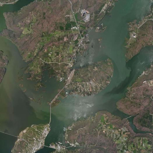
guntersville
[Lake Guntersville, Alabama’s largest lake, which was created with the construction of the Guntersville Dam by the TVA in the late 1930’s.]

At Places, Shannon Mattern reviews various practices which she collectively terms “infrastructural literacy” projects, including “touring, collecting, and documenting infrastructure” (the Los Angeles Urban Rangers, for instance), “sensing infrastructure” (Nick Sowers’ Soundscrapers), and “playing and performing infrastructure” (Smudge Studio’s Repository: A Typological Guide to America’s Ephemeral Nuclear Infrastructure).

While this is not the best quote to capture the full intent of the article, I was particularly fascinated by a short passage near the beginning quoting from Kevin Lynch’s Good City Form:

In one of his last books, the planner Kevin Lynch suggested that the landscape, through “graceful land management,” might open itself up to scrutiny and accounting. Planners might ensure that the “inner workings” of various “functional element[s] … are there to be seen if one is interested.” More specifically Lynch envisions “guidebooks to the sewer system, with instructions on how to read the season and the time of day by watching the flow. Signs, obscure marks, the traces of activity, listening devices, diagrams, remote sensors, magnifying glasses, slow-motion films, periscopes, peepholes — any of these may be used to make some process perceptible.”

Two fascinating things there. First, the idea of the seasonality of infrastructures — that a sewer system has an autumn, for instance — is quite accurate, but not entirely intuitive, perhaps because of the tendency to read infrastructures, like other artifices, as not-nature. Recognizing that infrastructures have seasonal and daily rhythms to them might be a useful clue not only to their utilitarian management, but also to the development of an infrastructural aesthetics (and, related, to understanding the infrastructural vernacular). Second, Lynch’s list of modes for direct engagement with infrastructure — particularly, of elements which might be included during the design of infrastructures to enhance “infrastructural literacy”: “signs, obscure marks, the traces of activity, listening devices, diagrams, remote sensors, magnifying glasses, slow-motion films, periscopes, peepholes”, which, of course, calls to mind the obscure markings that are actually used to describe the subsurface presence of infrastructures. It also leaves mammoth wishing for a designer or two putting the kind of effort into linking humans to infrastructural processes and flows through responsive systems that designers like the Living and Bradley Cantrell have put into such efforts with ecologies. (This has probably already been done and I’ve just managed to miss the examples.)

Elsewhere, Alan Wiig responds to Mattern’s article with an inversion of the premise, considering “infrastructure as a destination for tourism in and of itself”, via the example of the recreational use of reservoirs:

In the American West, a common example of this is the use of large water reservoirs for recreation: boating, jet skis, fishing, picnics, hiking and cycling, camping, and so on. Water that comes out of the tap downstream acts as sporting or entertainment when retained behind a dam for a time…

Unlike much of the work discussed in the Infrastructural Tourism essay, reservoirs are big, visible reminders of the reach of urban water systems, even if they typically are found far out in the hinterlands, out of sight from the population centers [they serve].

Having spent a good portion of my life in the American South, where the vast majority of inland recreational water use takes place on reservoirs owned by states and power companies, I’ve often wondered whether this dual role is perceptible or largely invisible. If the latter, how strange.

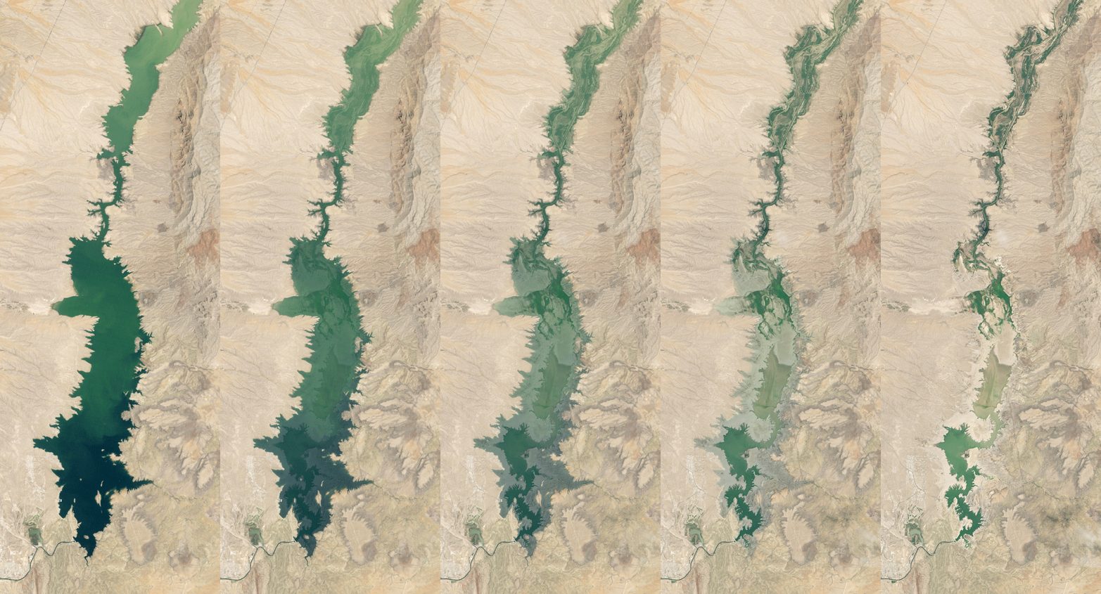
elephant butte reservoir

Elephante-Butte
[Elephant Butte Reservoir, New Mexico’s largest reservoir, which supplies water to “about 90,000 acres of farmland and nearly half the population of El Paso”; the GIF above (by mammoth) combines NASA Earth Observatory satellite imagery from 1994 and 2013 to show the depletion caused by repeated droughts since 2000. Now off to start tumblrs of GIFs of large-scale landscape change.]

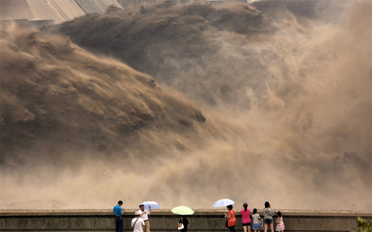
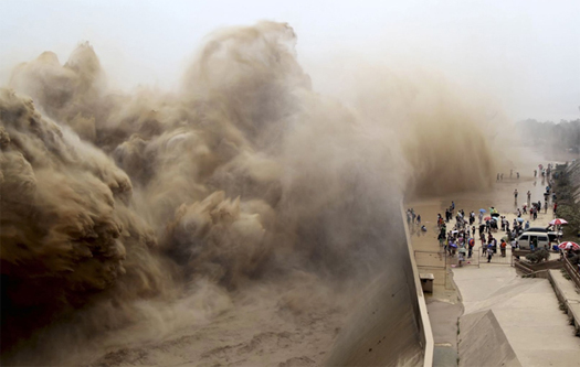
sediment trap and release

sediment-release-1

sediment-release-3
[The annual sediment release procedure at Xiaolangdi Dam on the Yellow River in Henan province, China. According to the Daily Mail, “this annual operation sees more than 30 million tonnes of silt sent downstream a year, with more than 390 million tonnes shifted this way over the last 13 years”.

It is noteworthy, from the perspective of the landscape architect, that this sediment release has become a public spectacle and yearly ritual for local citizens, as the Daily Mail also notes that “residents turn out to watch the annual event — and try to avoid a drenching by protecting themselves with umbrellas”. The Chinese Sedimentary Sublime, to bastardize David Nye. The scale of our geologic agency, made tangible by the compression of a full year of accelerated erosion into a tiny window of time and space (much like the recent removal of the Condit Dam in Washington state, which Brett Milligan has written about, though that was a private spectacle and involved much more than a year of stored sediment).

Meanwhile, the Mississippi River Delta is shrinking and starved of sediment, much of which is trapped behind dams far upstream, as geographer Richard Campanella noted in Places earlier this year:

“…many of our major river systems find themselves with too much sediment where we don’t want it, and too little where we desperately need it. Six major reservoirs constructed in the mid-20th century on the Missouri River, which historically transported 320,000,000 tons of suspended sediment annually to the Gulf Coast, now impound over three-quarters of that load behind their dams, where it reduces reservoir storage capacity and necessitates costly removal. On the downstream side of the dams, the unnaturally clear and swift-moving current (what hydrologists term “hungry water”) incises the channel and scrapes clean the banks of the carbon-rich fine-grain material needed for healthy fisheries. Similarly, eight locks and dams built between the 1870s and 1930s have converted what used to be the free-flowing Illinois River into a series of placid “pools” connected by mere trickles. The slowing of water therein has caused sediments to settle and fill backwater lakes and side channels, diminishing ecological productivity and recreational uses while increasing dredging costs for navigation. Similar scenarios occur on the Arkansas, Tennessee, and Upper Mississippi branches — indeed, on nearly every major river system nationwide.

Campanella’s full article — which culminates in an extremely intriguing proposal to alter the patterns of deposition for material dredged from the Mississippi River and release this trapped sediment via legal tactics — can be read here; mammoth discussed the six dams and six reservoirs of the Missouri River a couple years ago.

The sediment release photographs are from DDN Japan via a tweet by Jonathan Solomon.]

excess seaweed

qingdao_algae_4

qingdao_algae_1

qingdao_algae_3
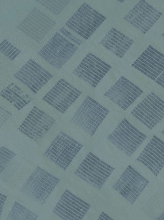
[Top: Seaweed farming rafts off the coast of the Chinese province of Jiangsu, south of the city of Qingdao, via Bing Maps.

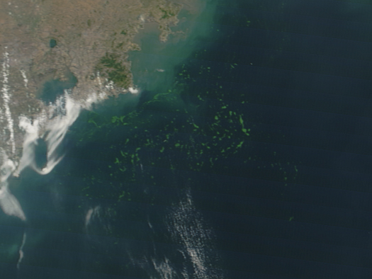
Middle: enormous mats of algae floating off the coast of Qingdao, as photographed on June 29th by NASA’s Terra satellite. The Los Angeles Times states that this is sixth year that the algae has proliferated so uncontrollably in Qingdao’s coastal waters; the area covered has been estimated at 11,500 square miles.

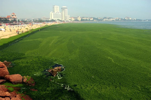
Above: the algae washes onto beaches, where local officials deploy boats, nets, and construction equipment to collect as much as 160 tons of algae a day, loading it into dump trucks and transporting it to a nearby “algae processing facility”.]

The New York Times reports:

Last month, [local officials] declared a “large-scale algae disaster,” sending hundreds of boats and bulldozers to clean up the waters off Qingdao, a former German concession in Shandong Province that is famous for its beer and beaches. As of Monday, about 19,800 tons of the algae had been cleared, the Qingdao government said. While valued for its nutrition — or as an ingredient in fertilizers and biomass energy production — algae in large quantities can prove dangerous as it decomposes, producing toxic hydrogen sulfide gas…

Although biologists are at a loss to explain the most recent algae bloom, scientists suspect it is connected to pollution and increased seaweed farming in the province just south of Shandong. While similar green tides have been reported around the world, the annual bloom in the Yellow Sea is considered the largest, growing to an estimated million tons of biomass each year.

The green tides were first reported in Qingdao in 2007. A central factor is the high supply of nutrients from agricultural runoff and wastewater. But those pollutants have been in the Yellow Sea for decades, leading scientists to look for new triggers.

A group of researchers believe that the algae that washes up around Qingdao originates farther south in seaweed farms along the coast of Jiangsu Province. The farms grow porphyra, known as nori in Japanese cuisine, on large rafts in coastal waters. The rafts attract a kind of algae called Ulva prolifera, and when the farmers clean them off each spring they spread the algae out into the Yellow Sea, where it finds nutrients and warm conditions ideal for blooming.

“It feeds off those nutrients and grows bigger and bigger, and eventually you can see it from satellites,” said John Keesing, a scientist at the Csiro Division of Marine and Atmospheric Research in Australia who is studying the green tide with Chinese researchers. “The currents gently move the algae in a northeastern direction out into the center of the Yellow Sea. You get a huge amount, and eventually it starts to wash on shore.”

This is feedback, the accumulated white noise of aquaculture.

very bad futurists

vector_gikas_detail
[Detail from a drawing by Lydia Gikas, for my Spring 2013 Houston Ship Channel studio]

The Studio-X blog links a recent article in Nautilus on the incorporation of scenario planning techniques (drawn from the work of futurists) into urban ecological research, by Marina Alberti‘s urban ecology research group at the University of Washington:

Alberti introduced me to the concept of scenarios through a large project she completed recently studying water use in the Snohomish River basin and Puget Sound area, including Seattle, over the next several decades. Scenarios, her report explains, are necessary for thinking long-term.

Future trends become highly uncertain, even with sophisticated predictive models. People not even yet born will be leaders in the [Snohomish] Basin. Buildings, bridges, levees, power lines will likely be torn down and rebuilt or redesigned. Technology we cannot even conceive of today might be a household staple. Climate impacts may fundamentally alter hydrological systems, such that miles of estuaries are transformed to salt marshes, and hundreds of acres of snowfields may disappear, exposing vegetation year-round for the first time in centuries. When we think fifty years out, what we know, even what we anticipate with models, becomes dwarfed by untested hypotheses”

Thus mathematical model… are the wrong tool, or at least not the only tool. What scenarios offer is a way to embrace uncertainty by swallowing it whole. They are informed narratives using the best science and best experience to provide “alternative descriptions or stories of how the future might unfold.”

In a post last year, I said that I think one of the ways that designers need to react to uncertainty and indeterminacy is by becoming “better futurists,  though that may often mean being a futurist at relatively small temporal and spatial scales”.

1 In part, I think this is an unintentional by-product of the insistence within process discourse (Corner, landscape urbanism, etc.) on the fertility of the ideas of indeterminacy and flux (which itself constituted a reaction to a modernist discourse of control) and, within that same process discourse, the diametric opposition of determinacy and indeterminacy. Design processes based on these ideas have proved difficult to implement (or to describe exactly how they are implemented within the strictures of practice), and I think this has unfortunately pointed us away from developing techniques for thinking rigorously about futures.

2 Here, I’m drawing on DeLanda’s explanation of bifurcation from A Thousand Years of Non-linear History, as I did in the “unknown unknowns” post referenced in the preceding paragraph:

“If one allows an intense flow of energy in and out of a system (that is, if one pushes it far from equilibrium), the number and type of possible historical outcomes greatly increases. Instead of a unique and simple form of stability, we now have multiple coexisting forms of varying complexity (stable, periodic, and chaotic attractors). Moreover, when a system switches from one stable state to another (at a critical point called a bifurcation), minor fluctuations may play a crucial role in deciding the outcome.”

I’ve become increasingly convinced of two related claims. First, that designers are very bad futurists. We lack tools, conceptual frameworks, and processes for dealing rigorously with future possibilities [1]. In particular, we tend to ignore the tendency of futures towards unpredictable bifurcations [2]. (How many designers have you seen present their work beginning with an analysis that admits more than one possible future? Have you ever seen a design presentation for a capital project truly incorporate more than one possible future?) Because of this, we typically design on the basis of extremely rudimentary conceptions of the future (some conception of the future of a landscape is usually a component of “site analysis”, even if it is not explicitly labelled as a future), assuming a stability that does not exist, failing to recognize the significance of black swans, and over-estimating the efficacy of our intuitive analyses of futures, thus also over-estimating the likelihood of events unfolding in the manner that we have predicted. This very bad futurism is an extremely unstable foundation for design, particularly as we grapple with large spatial scales, long time scales, and a global environment that increasingly exists, in Seth Denizen’s memorable phrasing, “at right angles” to the world we have known.

A time of increasing environmental uncertainty is a particularly bad time to be designing without rigorous approaches to futures.

vector_gikas_small

[Full final “bifurcating combinatorial vector” drawing by Lydia Gikas]

3 “If events such as DredgeFest NYC and the conception of the dredge cycle have something unique to offer in this conversation, it is recognizing the quasi-designed linkages between multiple anthropogenically-driven landscape processes, be they dredging itself, beach nourishment, the Panama Canal Expansion, wetlands both eroding and accreting, coastal development, or sea level rise and ever-increasing frequencies of intense storms. Observing and acting upon these networked material relations is at least as critical to the resilience of urban systems as dealing with any individual component in isolation. The salt marshes of Jamaica Bay shrank for a hundred years without any human intervention intended to ameliorate or reverse that shrinkage. Restoration work only began when a seemingly unconnected event in a distant country, the Canal Expansion, produced a sudden surplus of suitable sand, and engineers and scientists opportunistically seized the chance to utilize that surplus. Re-designing the dredge cycle for the Anthropocene will require observing, designing, and manipulating such feedbacks, harnessing their aggregate energy so that they strengthen rather than undermine systemic resiliency.”

In the studio on the Houston Ship Channel that I ran this past spring semester at Louisiana State University, “Aorta”, I began to pick at this issue (though I should probably apologize to my students for using them as guinea pigs in an early and tentative experiment in introducing rigor into thinking about futures within the design process).

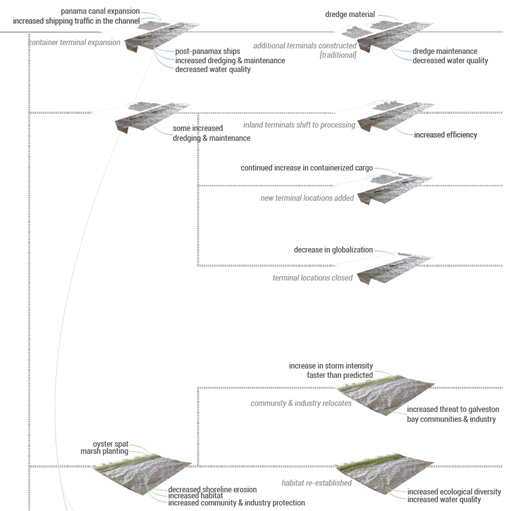
Throughout the semester, we worked with a set of drawings that I called vectors. In the earliest iterations, these drawings were intended to encode and make explicit each student’s assumptions about the future trajectories of landscapes their project was considering, whether Ship Channel oil refineries, artificial dredge islands, or Galveston Bay beaches. By the end of the semester, the early vector drawings had been revised, mated, and altered several times, arriving at branching combinatorial vectors. Where the initial vectors were extreme simplifications, suggesting a linear and predictable progression from known current landscapes towards probable future landscapes based on anticipated changes in inputs and outputs, the branching combinatorial vectors recorded both interaction between various vectors — recognizing that the fates of beaches and dredge islands, for instance, are inextricably linked, and (perhaps more importantly) that those linkages might be design opportunities [3] — and a multiplicity of potential futures for each vector, recognizing that the likely scenarios encoded in earlier versions of the vectors might indeed be likely, but could not be certain.

This set up a set of questions for the final designs that I think are extremely important: how could the designs accommodate or react to this range of potential futures? Do some of them render it obsolete? Would others amplify potentials within the proposals that are currently latent?

The second claim that I am increasingly convinced of is that design has a great deal to gain in the attempt to rectify this weakness by drawing upon the expertise of the discipline of futures studies, to inform the development of the tools, conceptual frameworks, and processes that we lack. As Studio-X writes, “corporations and the military have been using this technique [of scenario-based forecasting] in their long-range planning for years, but architects, ecologists, and urbanists have been slower to adopt it” — and scenario planning is a technique that was introduced decades ago, only one of the set of techniques clustered together under the general term “anticipatory thinking protocols”, which also includes things like the Delphi method, casual layered analysis, and environmental scanning. Beyond anticipatory thinking, futurists have many other techniques: relevance trees, failure mode and effects analysis, backcasting, and so on, all with their own strengths and weaknesses which have been explored through utilization. We would do well to mine these techniques and cross-breed them with established design processes; doing so could be the start of developing a more rigorous approach to futures within design.

One promising development with regard to the evolution and implementation of more rigorous approaches to futures — though not drawn from future studies specifically — is the work of the Flux City studio at Harvard, which is led by Chris Reed and one of those enormous armies of instructors that the GSD employs. Reed recently filed a “studio report” at Urban Omnibus, which discusses the studio in general and some of the specific projects produced in the studio this past semester. It’s well worth a read.

Hopefully I’ll have more to say about the Houston Ship Channel studio later this summer — I’m hoping to spend a fair bit of time unpacking the results of the work that I’ve done over the past year, which includes that studio plus another last fall at Virginia Tech, a seminar on contemporary landscape theory at LSU (“Gantry Cranes, Kudzu Fields, and Rolling Blackouts”), as well as various writing, presentations, and research. No promises.

unknown fields division: madgascar

betsiboka_river delta
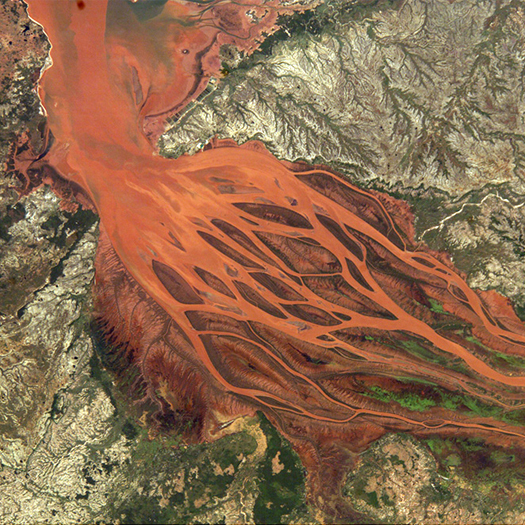
[The Betsiboka River’s delta, flush with eroded sediments; source: NASA EO.]

This summer’s Unknown Fields Division is headed to Madagascar:

…Unknown Fields heads to Madagascar to catalogue the push and pull of economy and ecology and to trace the shadows of the world’s desires across the landscapes of this treasured island.  Along our way we seek to uncover some of the complex value negotiations that play out across this unique island and craft new stories from statistics, data, predictions, projections, measurements and offsets.

The Division will venture through wild west sapphire towns and mining landscapes and trek through rainforests ringing with the song of the Indri in search of rare and undiscovered treasures, a menagerie of preciousness and scarcity, of rubies, minerals and exotic spices, of ring tailed Lemurs, ‘octopus’ trees, and carnivorous plants; of pigmy chameleons, tomato frogs and moon moths. We will travel by plane and pirogue, train and taxi-brousse, from rough roads to rough seas, to fishing villages and up rivers silted with eroded soils. Unknown Fields will reimagine a territory that is equally wondrous and scarred as we follow the trail of global resource extraction into the heart of the most unique ecosystem on the planet.

Joining us on tour will be international collaborators from the worlds of technology, science and fiction, and together we will form a travelling circus of research visits, field reportage, rolling discussions and impromptu tutorials that will be chronicled in a publication and film developed en route.

Applications are open through June 14th; the Division will be in Madagascar for 14 days, from mid to late July. Find more details on the Unknown Fields Division blog.

feedback: designing the dredge cycle

df_04
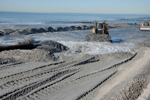
[Beach replenishment on Rockaway Beach, New York (well before Hurricane Sandy); image via USACE]

Fellow Dredge Research Collaborator Brett Milligan and I have a co-authored article in the latest issue of Scenario Journal (formerly Landscape Urbanism Journal), 04: Rethinking Infrastructure. The article reflects on the after effects of Hurricane Sandy, the history and future of Jamaica Bay, and lessons learned at DredgeFest NYC:

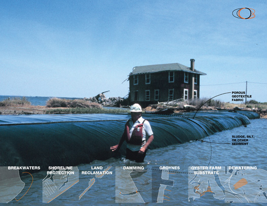
“In the wake of the storm, the pivotal role of New York’s sedimentary infrastructures in both enabling commerce within the harbor and serving as bulwarks against and dissipaters of storm surge was highlighted, shedding new light on the urgency of the task of understanding and contending with climate change, coastal resiliency, and the dredge cycle in tandem. A wide variety of responses to the storm have been broached in the press by politicians, designers, engineers, and scientists: multi-billion dollar surge barriers permanently emplaced in the harbor [32]; home buyouts in flood-damaged areas with the intention of retreating from the most heavily impacted zones[33]; “grassy network of land-based parks accompanied by watery patches of wetlands and tidal salt marshes,” as well as “breakwater islands made of geotextile tubes and covered with marine plantings” [34]; strategically hardening infrastructures to better absorb the impact of and ride out flooding when it does occur; and “a system of artificial reefs in the channel and the bay built out of rocks, shells and fuzzy rope that is intended to nurture the growth of oysters,” “nature’s wave attenuators” [35].

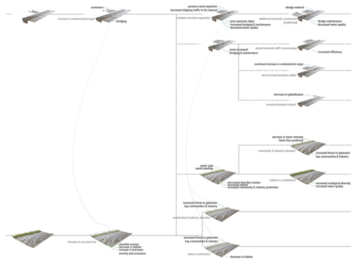
If events such as DredgeFest NYC and the conception of the dredge cycle have something unique to offer in this conversation, it is recognizing the quasi-designed linkages between multiple anthropogenically-driven landscape processes, be they dredging itself, beach nourishment, the Panama Canal Expansion, wetlands both eroding and accreting, coastal development, or sea level rise and ever-increasing frequencies of intense storms. Observing and acting upon these networked material relations is at least as critical to the resilience of urban systems as dealing with any individual component in isolation. The salt marshes of Jamaica Bay shrank for a hundred years without any human intervention intended to ameliorate or reverse that shrinkage. Restoration work only began when a seemingly unconnected event in a distant country, the Canal Expansion, produced a sudden surplus of suitable sand, and engineers and scientists opportunistically seized the chance to utilize that surplus. Re-designing the dredge cycle for the Anthropocene will require observing, designing, and manipulating such feedbacks, harnessing their aggregate energy so that they strengthen rather than undermine systemic resiliency.”

You can read the full article at Scenario Journal.

[Speaking of the future of Jamaica Bay: you might want to check out “Protective Ecologies”, a short video produced by several of our DredgeFest collaborators — Gena Wirth, Alex Chohlas-Wood, and Ben Mendelsohn. “Protective Ecologies” was recently included in an exhibition at MoMA’s PS1 VW Dome 2. Speaking of Scenarios Journal 04, there are a number of other fantastic essays in the issue; I’ll probably excerpt a couple of the most intriguing ones over the next few days or weeks.]

the geopolitics of subtraction

IIRSA
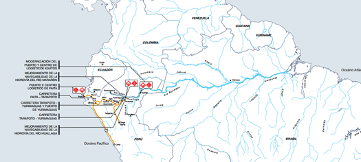
[Map of the IIRSA’s Amazonian axis, connecting the Pacific to the Atlantic across the Andes; from IIRSA document “8 Ejes de Integración de la Infraestructura de América del Sur”]

Keller Easterling, speculating about “a new counterintuitive economic model” of “infrastructural subtraction” in Domus last November:

“What are the points of leverage, trip distances or economies of scale that make air freight or rail profitable? Architects and urbanist are not themselves logisticians or inventors of new transportation technologies, but they can run the development scenarios demonstrating their spatial consequences. The license to develop may be expressed in terms of remote offsets like schools, technologies and improvements to community that recalibrate and shrink the need for roads. Roads might only exist when bundled with underground utilities, forest buffers, wireless telecommunication and other suppressors…

Just as architects are learning to look past single design events or objects, some of the most interesting scientists and economists in the world are learning to look past the rational assumptions of science to test ideas in a more complex context with multiple actors and circumstances. The soupy matrix of spatial protocols is a rich test bed for these new questions and for new extra-state agreements that pivot around seemingly irrational or changeable desires. In the Amazon and elsewhere, architects may be valuable precisely because they are not offering a hard science but rather an art of subtraction.”

This seems an extremely important space to define: if architects and landscape architects are interested, as Easterling suggests they should be, in developing the capacity to efficaciously alter or disturb the trajectory of organizational protocols which produce large-scale territorial effects like the two Easterling describes in the Domus article, Yasuni-ITT (in which the Ecuadorian government sells stakes in not developing oil resources within the Yasuní preserve) and the conflicting IIRSA (Initiative for the Integration of the Regional Infrastructure of South America, which aims to “integrate highway networks, river ways, hydroelectric dams and telecommunications links throughout the [South American] continent”), then we designers may need to demonstrate a peculiar utility that we offer — some set of intelligences or capacities innate or developable within the spatial design disciplines that make them useful to the design of such organizational protocols (hence, “valuable precisely because they are not offering a hard science but rather an art of subtraction”) — while simultaneously developing modes of practice and design tools that have the capacity to act on such protocols.

Easterling’s article has suggestions for the latter, as well, describing this “art of subtraction” as a new territory for design, “a perverse expertise”  “tutored by the bad company [architects] keep”:

“Since architects know to how make the development machine lurch forward, might they not also know how to put it into reverse? Might they know how to design and incentivise not only the addition but also the subtraction of development?”

The puzzle of subtraction or negative development clearly turns on quotients of space, yet it might outwit the architect who applies only the customary approach to the familiar site, building or master plan. Global development conundrums like those in the Amazon perhaps tutor an approach to form-making that does not produce the single design event or object, but rather form in a register that the political world can more easily use.

While the remote controls of foreign developers or runaway market multipliers are the source of despair for many preservationists, they might also be a source of ingenious design by architects and urbanists who design counter-multipliers or counter-remotes. Exceeding the reach of single object form, a subtraction protocol might establish an interdependency of variables that addresses multiple sites over time — a cos X that acts as a valve or governor to suppress, leverage or offset development. Just as cos X is an expression for a stream of values, these active forms, unlike a master plan, might simply provide a delta for development concentration and contraction.”

Read the full article at Domus.

future baroque

The following piece was published last summer in La Tempestad; given that La Tempestad circulates primarily in Mexico and is published in Spanish, we — Brett Milligan and I, who co-authored the piece — thought that it would be worth re-publishing it on our respective sites for English-language audiences. The article builds on a pair of posts from about two years ago: first, Brett describing a visit to I-5 Colonnade Park on Free Association Design, and, second, a post at mammoth that described Colonnade Park variously in terms of an “infrastructural vernacular” and Brian Davis’s formulation of “leisure-work” landscapes. In the text below, we move beyond these initial reactions to argue that Colonnade Park suggests an alternative to the dominance of the capital project in landscape architecture, an alternative that opens up new aesthetic and performative domains based on difference, variability, and the agency of both individual and communal labor. 

img_9949sm1

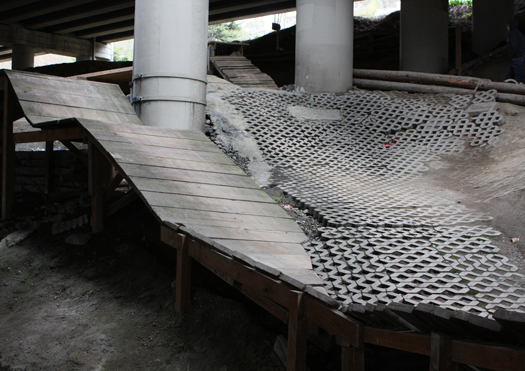
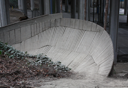
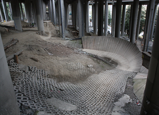
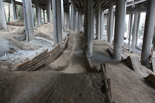
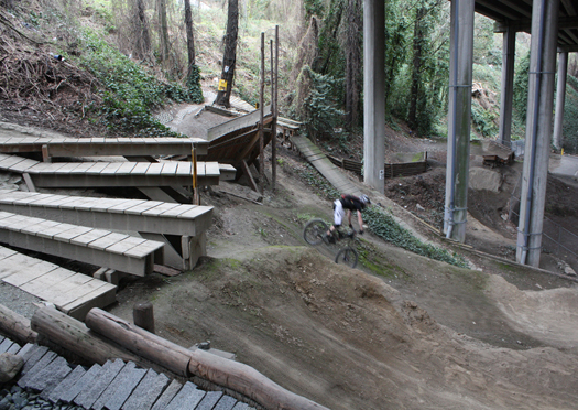
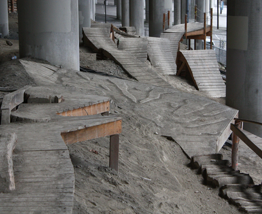
Beneath the deeply-shaded underbelly of an elevated section of Seattle’s I-5 freeway, Colonnade Bike Park tumbles freely downhill across steep and jumbled terrain, occupying formerly barren and listless ground. Ramps, berms, drops, and various homespun earth-retaining systems slip between the industrial cathedral’s neatly-spaced namesake concrete pilings, aggregating into roughly pixelated surfaces, which in turn form a series of circuits for the local mountain biking community that designed, built, maintains, and rides in the park.

Like the tricks pulled by the bikers careening across its wood, concrete and earth, the park feels improvised. Much of the material to build it was donated or recycled from demolition projects around the city. Sandstone pavers torn out of cobblestone streets that linked the neighborhoods east and west of the park before the freeway viaduct split them were donated by the Seattle Historical Society. Antique Douglas Fir joists and framing were donated from a renovation project a local mountain biker was working on. A logger friend supplies the Park with a steady supply of “mill reject cedar logs”, logs which are too large, too small, or too deformed to meet the standards of commercial cedar processing. Scraps — pressure-treated lumber, fasteners, and other materials discarded on local construction projects — are brought to the Park and recycled into tracks, jumps, drops, and wall rides. Ordinary off-the-shelf items have been retooled, like the permeable concrete waffle pavers that have been converted into ad-hoc cellular confinement systems.

ramp-sm

img_9953sm

The accumulated effect of this process of ceaseless improvisation — the Park’s two acres took roughly four years to construct and design is ever ongoing– is a distinctively raw aesthetic. Like many contemporary urban parks, including New York’s (over-)celebrated High Line, Colonnade Park draws much of its aesthetic appeal from the character of the industrial infrastructure it shares space with. Yet rather than introducing crisp contemporary minimalism to contrast with that infrastructure, as many of its more famous contemporaries do, the decisively functional arrangement of the Park’s angled planes of waffle pavers and bermed piles of recycled dirt amplifies the raw instrumentality of the viaduct above.

But, as appealing as it is, the lo-fi aesthetic of these pragmatic and hand-made constructions is not the most important lesson of the Park. What Colonnade Park suggests is a re-orientation of the practice of landscape architecture away from faceless capital and towards creative and vested labor; away from design elitism and towards the participation of the users of a landscape in its construction; and away from standardization and mechanization towards difference, variability and the instantiated volition of the individual laborer.

Public urban landscapes — parks, plazas, squares — are often referred to as “capital projects” by those who build them — politicians, developers, architects, construction firms, planners, contractors, and so on. The use of that particular term recognizes the central mobilizing and productive role of capital in their construction. When capital plays this primary role, the quality of a landscape is understood to be determined in large part by the quantity of capital that can be devoted to it: to “upgrade” a plaza is to replace cheap concrete and unit pavers with expensive stone, wood, and metals; to spend more money is to improve. At the same time, to hold down costs for the production and installation of materials, standardization is essential, and where difference is introduced — in the algorithmic variations common to parametric design, for instance — it is introduced most often at the production stage, where capital is most easily applied.

img_9916sm

Colonnade Park presents an alternative.  The Park was built with relatively minimal funding, using refurbished materials. But because of the massive quantity of skilled volunteer labor available, those materials have been fitted together in almost endlessly variegated combinations. As the volunteers who built the park are mountain bikers who wanted to ride in it, the Park is deeply customized to the spatial practices situated within it. Thus the shift from a capital-intensive landscape architecture to a labor-intensive landscape architecture is enabled by the presence of an interested and knowledgeable community which is willing and able to labor in a landscape voluntarily and without pay, for the rewards contained within and produced by that act of labor. This is a different kind of labor, and it heralds new possibilities for landscape design.

To understand these possibilities, it may be helpful to think briefly about the intertwined history of labor and landscape. Perhaps more than other forms of design, labor and landscape are co-generators of one another.  Human behaviors and landscape processes feedback on one another, as the literal liveliness of the materials used to construct landscapes — most obviously, plants, but also animals, fungi, bacteria, insects, and even inanimate substances like sediments, soils, and water which nonetheless possess aggregate behaviors — requires that constructed landscapes are continuously maintained and always evolving, in a struggle between growth and entropy, which are not always easily distinguished. This process of continuous maintenance is not necessarily capital intensive, but it is typically labor intensive. Think of the difference between the process of weeding a garden by hand and maintaining a strip mall planting buffer with weed-whackers and leaf blowers; think of the delicacy and intricacy of the former landscape, and the bluntness of the latter.

Viewed from a historical perspective, the contemporary capital project, with its emphasis on the agency of capital over labor, is an aberration. From the construction of pyramids in Egypt and Mesoamerica, to Roman villas and Qing dynasty gardens, to Bramante and Ligono in the Italian Renaissance, or even Humphrey Repton and Capability Brown in Romantic England, the practice of both monumental and ornamental landscape modification was long defined by a reliance on the mobilization of vast quantities of (often subjugated) human labor quarrying stone, pruning trees, excavating earth. At even broader spatial and temporal scales, the aggregate effects of persistent labor have historically produced some of our earliest and largest geo-biological impacts: terrace cultivation on hillsides in China and the Andes, the pre-Columbian transformation of North American biomes through the persistent annual application of fire, the co-evolved hedgerow ecologies of Western European farmland, and even, as recent archaeological evidence suggests, the fertile, anthropogenically-induced “terra preta” soils of the Amazon.


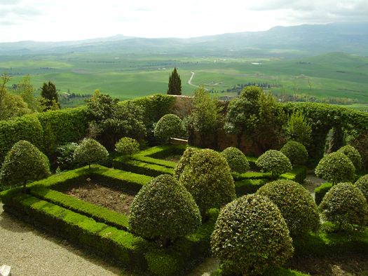
[Piccolomini Gardens, via Wikimedia.]

Perhaps the most extravagant examples of labor-based landscape modification are the incredibly maintenance-intensive geometries of Baroque gardens, most prominently found in France and Italy. Intended to realize a peculiar set of ideas about the relationship between symmetry, geometry, and the proper ordering and control of both the physical and moral universes that were endemic to that time and place, the Baroque gardens employed armies of skilled and semi-skilled landscape laborers in long struggles against the unruly entropic tendencies of boxwoods and poplars that were constantly trying to escape their confinement into crisply rectilinear parterres, bosquets, and allees. But setting aside the specific philosophical motivations of these gardeners, though, it is not difficult to imagine an alternative Baroque — perhaps we will call it the Ecological Baroque, or the Performative Baroque — equally extravagant in its application of labor to the transformation of landscape, yet aimed towards the realization of an entirely different set of ends: the enhancement and growth of ecological productivity.

OLYMPUS DIGITAL CAMERA
[How a “sustainable site” is constructed; source]

OLYMPUS DIGITAL CAMERA
[Community planting on a dredge island in the Chesapeake Bay; source]

To envision this Performative Baroque, imagine swarms of volunteer gardeners, acting in concert to re-make the floral composition of an urban landscape. Harvesting one set of urban voids for fast-growing grasses and perennials whose biomass can be converted into fuel. Seeding roadbanks and railways with erosion-halting vegetation. Setting up watches over cryptoforests and freakologies to record patterns of interaction between fauna and flora, and then establishing botanical kill lists of species to be removed for their lack of utility, while encouraging others that host a particular insect species which is struggling. Instead of trucking in groves of “native” trees and burying elaborate irrigation prostheses to support them, as a capital-intensive landscape architecture does, these landscapers would curate the slow successional evolution of new forests on abandoned lots, terrain vague, and infrastructural leftovers. The city would be their garden.

This picture reveals a critical difference between the historical pattern of landscapes produced by an extravagance of labor and a future turn back towards labor, a crucial difference between the hands that carved the Baroque gardens of Vaux le Vicomte out of resistant plants and the mountain bikers who hammered together Colonnade Park. That difference is that the historical pattern is of involuntary labor — at best, wage labor, performed at the behest of a benefactor able to afford wages in the pursuit of some vision — but a future turn towards labor will hinge on voluntary volition. If there is to be an Ecological Baroque, it will be built by willing hands.

baroque_1

img_9951sm

What would motivate hosts of volunteers? Why would they lend their time and talents to such collective efforts? If we return to Colonnade Park, we find the coming together of key components that were integral to the making the Park a physical reality. First — and perhaps most importantly — someone had to recognize the latent potential of those couple of abandoned acres beneath I-5. In this case, that someone was a local bike shop owner, Simon Lawton, who was already riding his bike under the viaduct. Lawton’s rides convinced him that the site was perfect for a bike park. The freeway above sheltered it from Seattle’s persistent winter rains.  The irregular but steep topography was well-suited to the introduction of circuit tracks without requiring extensive artificial grading, and, in its then-state of abandonment, the shadowed space was considered a safety hazard by the future park’s neighbors. Lawton took this vision to a series of local organizations and constituencies, including Seattle City Parks and Recreation, a local neighborhood council, Urban Sparks (a non-profit group specializing in kickstarting urban community projects), and, crucially, the Evergreen Mountain Bike Alliance, Seattle’s largest mountain biking advocacy and trail maintenance organization. Once each of those organizations had been convinced that a bike park could and should be built beneath I-5, it was the Evergreen Mountain Bike Alliance that mobilized networks of resources — like the streams of surplus construction materials that were fashioned into the physical infrastructure of the bike park and communities of volunteers to construct it. Lawton’s creative opportunism provided the spark, and the presence of constituency that bought into that original creative vision generated a pool of labor that was both invested in the maturation of the vision and capable of pursuing the vision with a great deal of individual creativity. That is, the bikers wanted to ride in the future park themselves and as experienced bikers, the volunteers possessed an innate and specific understanding of the physical geometry of the future uses of the park.

Neither of these things are true of the labor employed on the typical capital project. Like most labor in the Post-Fordist economy, the labor employed on capital projects is specialized, corporatized, homogeneous, and standardized; it is fundamentally ill-suited to craft, at once inimical to difference through standardization and resistant to holistic understanding because of the specialization demanded for economic efficiency.

baroque_2

img_9939sm

Freed from the constraints imposed by the dominance of capital, the pooled labor of groups of people defined by shared spatial proclivities — not just mountain bikers, but also skateboarders, soccer players, drag racers, parkour traceurs, rock climbers and boulderers, paintballers, and bird watchers — could begin to generate urban public landscapes which are more idiosyncratic and more differentiated than the public parks of the twentieth century. Similarly, the labor of knowledgeable and motivated ecological hobbyists could transform gardening from an individualistic and primarily ornamental practice into a communal effort, cultivating whole and diversified cities. Labor, which like the volunteer labor that built Colonnade Park, is uniquely motivated, local, and capable of imbuing its work with creative intent, falls outside the typical boundaries of landscape architecture as ‘professionally practiced’. And as these vested pools of labor fuse user, designer and builder they are more invested and broadly knowledgeable of its future use and how it will be occupied than the wage laborers of capital projects, opening diverse realms of possibility for the design of urban landscapes.

The photos in this post are, unless otherwise specified, taken by Brett Milligan. The photos which are by Brett and not of Colonnade Park are from the Goats on Belmont project, which took advantage of a bit of non-human labor to cultivate change. This post is cross-posted at Free Association Design. The account of the construction of Colonnade Park that this piece is based on was pieced together from interviews that Brett conducted with Glenn Glover and Mike Westra of the Evergreen Mountain Bike Alliance.

changing industrial landscapes and the city that never was

Quickly, a pair of events (well, an event and an event series) that I am a bit late to mentioning.


[photograph by Ricardo Espinosa]

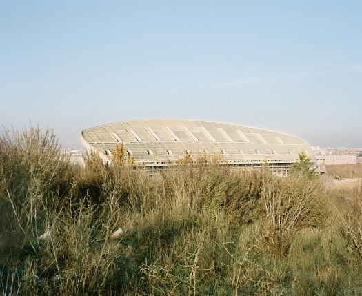
The first is “The City That Never Was”, a symposium “organized by Christopher Marcinkoski and Javier Arpa, in cooperation with the Architectural League of New York; speakers include Iñaki Abalos, Dominique Alba, Enric Batlle, William Braham, Rania Ghosn, Llàtzer Moix, Robin Nagle, Chris Reed, Willie van den Broek, James von Klemperer, Richard Weller and Daniel Zarza”, “us[ing] the current economic and urban crisis in Spain as a lens through which to consider future patterns of urbanization and settlement”:

“In the twenty years following its accession to the European Union in 1986, Spain underwent unprecedented physical development that radically reshaped its major cities and metropolitan areas. From new housing to commercial and cultural facilities to infrastructure, the country experienced a building boom of such remarkable proportions that by 2005, 20% of Spain’s GDP was attributable to construction-related activities. The equivalent figure for the United States at that time was less than 5%. A year later, The New York Times celebrated Spain as “one of the great architectural success stories in modern history” when reviewing the Museum of Modern Art’s 2006 exhibition On Site: New Architecture in Spain.

Yet today Spain copes with an unemployment rate in excess of 26% and a GDP — according to the latest IMF forecast — expected to shrink by 1.5% this year. The country is littered with unfinished, partially completed or abandoned developments including housing complexes left unenclosed; empty museum buildings with no collections; hundreds of miles of unused roads; and airports without a single arrival or departure. This condition is most severe in Madrid, where over 25% of the urbanized land in and around the city consists of partly vacant or incomplete projects.

However extreme its outcome, this overdevelopment is not unique to Spain. Rather, episodes of failed speculative urbanization are a recurrent circumstance throughout history, taking place at a range of scales with varying degrees of long-term effect. Recent examples of this phenomenon can be found in the Sunbelt region of the United States, as well as in Ireland, Iceland, Panama, Angola, Kenya, and the Persian Gulf. China in particular has been under increased scrutiny of late as a growing number of media reports and images emerge of massive, unoccupied new settlement being built in the country’s interior western and southern provinces. This proliferation globally of unoccupied and incomplete settlement over the past 20 years illustrates broader trends in the processes of urbanization, trends in which presumptions of — and desires for — continuous economic growth instigate intense financial investment and real estate speculation, seemingly indifferent to considerations of local and regional capacities, or changing market demands.

This one-day symposium will use the situation in Spain as a point of departure for challenging the increasingly generic strategies upon which contemporary urban planning and design rely in both established and emerging economies. The event will be organized through four primary themes related to the City That Never Was phenomenon— infrastructurewastelandscape, and instant urbanism — in order to explore new possibilities for how future formats of urbanization can be conceived, financed, planned, deployed and inhabited.”

The symposium is tomorrow (I said I was a little bit late!), at the Scholastic Auditorium in New York. Tickets are available through the Architectural League’s website through 5 pm today, and then tomorrow at the door. The Architectural League has also produced a small set of features on the topic, including interviews and images, which can be found here.
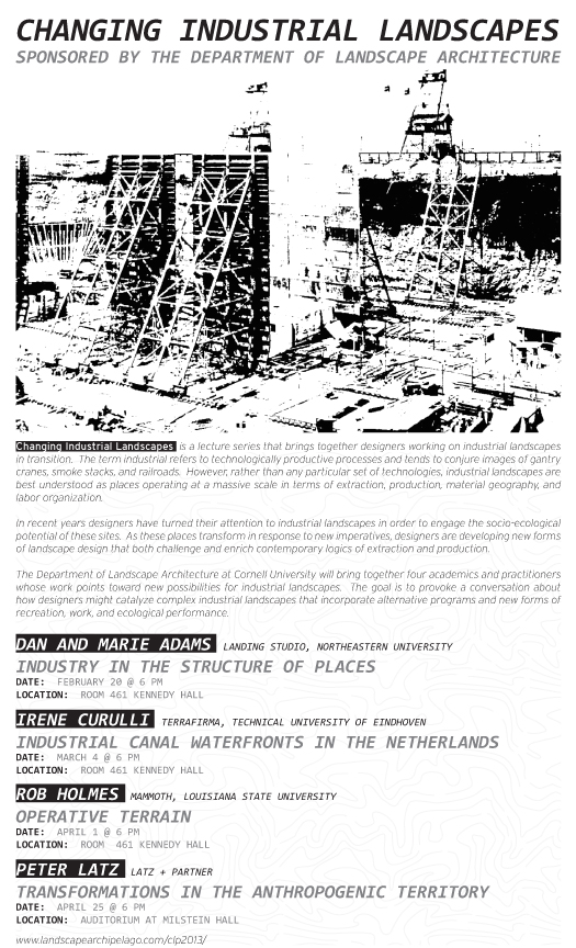
The second — the event series — is “Changing Industrial Landscapes”, a subset of the “2013 Cornell Landscape Project” (within the landscape department at Cornell University, which is sponsoring the series). Thematically organized by the Student ASLA and instructors Thomas Oles and Brian Davis, “Changing Industrial Landscapes” focuses “on landscape projects working at the scale of past and future industrial practices”. Dan and Marie Adams of Landing Studio spoke first — last night — and Brian claims both that it was excellent and that he’ll have a summary up in the near future.
Irene Curulli follows on March 4, I speak on April 1, and Peter Latz on April 25.

I’ll be giving a version of a new talk I’ve been developing (debuted here at LSU this past Monday), on what I am dubbing “operative terrain”:

A Target, a Books-a-Million, a movie theater, a Starbucks, and a sea of parking; a switching yard filled with double-stacked railcars; a right-of-way, a shoulder, four lanes, a median, four lanes, a shoulder, and another right-of-way; a coal-fired power plant, ash ponds, dikes, sluices, diversion channels, and drying cells (fly ash slurry safely confined, it seems). Such landscapes constitute the bulk of contemporary urbanized territory and, given the regimes of resource extraction and flows of material and goods that mark even nominally rural landscapes, linking cities to distant hinterlands, it might be argued that most territory is urbanized. These landscapes are not so much designed as they are formatted by economic and logistical imperatives. Particularly notable among them are territories that are being actively formatted by industrial, infrastructural, and logistical operations: dredge containment facilities, waste reservoirs, exurban warehouse districts. This operative terrain is essential to the economies of urban systems, hosting and channelling the various material and energetic flows that enable urbanization, yet it also often generates a host of undesirable consequences, and may also–more optimistically–harbor unrealized potential. What is the role of landscape architecture within this terrain?

It’s an exciting talk for me, as it synthesizes many of mammoth‘s concerns from the past several years (including the unfortunately under-blogged 2012) and attempts to shovel them into a framework for one set of new directions for landscape architecture that I argue are critical to developing an effective disciplinary response to the scale of contemporary environmental challenges produced by anthropogenic activity. It’s probably even more exciting to see it situated within the context of a broader set of designers who are responding within this terrain (in much more effective ways than I am), so my only disappointment with the series is that I can’t be in Ithaca for the other three lectures. If you can, you should.

bracket goes soft

1 This is not entirely true. There was a third launch, at the University of Waterloo, earlier this morning.

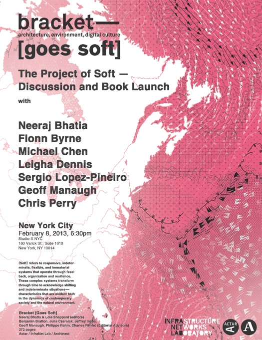
I’m a bit late to getting notice of these events up, but at least I’m doing it before they happen1: there are two book launches scheduled for the latest installment of Bracket, [goes Soft].

Bracket [goes Soft] examines the use and implications of soft today – from the scale of material innovation to territorial networks. While the projects in Bracket 2 are diverse in deployment and issues they engage, they share several key characteristics — proposing systems, networks and technologies that are responsive, adaptable, scalable, non-linear, and multivalent.

The first launch event is tomorrow evening, at Studio-X NYC:

Drop by Studio-X NYC this Friday evening for the New York City book launch of the next installment in the fantastic Bracket series: Bracket [goes Soft]. There will be wine, books for sale, and a series of short presentations on the subject of soft from the book’s editors, editorial advisers, and contributors, including Neeraj Bhatia, Fionn Byrne, Michael Chen, Leigha Dennis, Sergio Lopez-Pineiro, Geoff Manaugh, and Chris Perry. Hope to see you there!

The second is a little over a week from now, in Houston on February 17 (7 pm) at Architecture Center Houston, and will feature editor Neeraj Bhatia, Scott Colman, Ned Dodington, and Christopher Hight.


[Geotube deployment strategies; photo via NOAA, drawing by the Dredge Research Collaborative.]

I’m disappointed that I’m going to miss both (Houston more narrowly than New York, as I’ll be in Houston with my Houston Ship Channel studio only a few days later), particularly since Bracket [goes Soft] played a key role in bringing together the Dredge Research Collaborative and focusing our work on the anthropogenic sediment handling practices that we’ve become fascinated with. We have a short piece in [goes Soft], entitled (rather plainly) “Dredge”:

A continuous stream of shipping barges pass through the Mississippi River Delta, moving over 350 million tonnes a year through its three largest ports. Of those, the Port of South Louisiana alone stretches 87 kilometers along the Mississippi, and annually sees some 4,000 ocean-going vessels and 50,000 barges. It is the largest tonnage port in the Western Hemisphere, and the fifth-largest in the world. To maintain this logistical flow, channels — their size and depth determined by the needs of the international shipping industry — must be kept clear. No small task, due to the 200 million tons of sediment that are carried down the river every year. Much of this sediment is washed out to sea or deposited inoffensively along the banks, but a significant portion of comes to rest in industrially inconvenient places. In the Army Corps of Engineers’ (USACE) “Mississippi Valley” division, around 10 million tons of such sediment must be shifted each year. The channels are dredged, and refill, and are dredged and refill. It is to the processes that shape this landscape, and others like it, that we turn our attention.

You can check out the full piece — and many other, more interesting articles and projects — by picking up a copy of [goes Soft].

louisiana state university

So, I should say something about what I’m doing this spring, though this is kind of the brief version.

I’m very excited to be joining the faculty and students at LSU’s Robert Reich School of Landscape Architecture as the visiting Marie M. Bickham Chair. In addition to taking in the extremely interesting work that they’re doing here, I’ll be teaching a pair of classes — a design studio on the Houston Ship Channel and a theory seminar entitled “Gantry Cranes, Kudzu Fields, and Rolling Blackouts”, both of which I’ll talk about at a bit more length in the near future — and, to get the semester started, organizing the School’s “Design Week”, a three-day design exercise open to the majority of the School’s students.

For that, I’m similarly excited that Mason White (Lateral Office, Toronto, Infranet Lab) has agreed to help me lead Design Week. We’ve got what I think is a pretty exciting exercise planned (furthering mammoth‘s current obsession with containerization as a generator of landscape typologies, and linking into Mason’s extensive research into the architectural potential of new spatial typologies generated by logistics and other infrastructural operations) but I don’t want to give too much about it away before it gets started. I will say that this means that Mason will be giving a talk at the School next Wednesday, the 16th, at 5:00 pm, the advertisement for which is below.

More soon…

making the geologic now


[Jinanqiao Dam under construction on the Jinsha River. New “mega-dams” such as Jinanqiao in high seismic risk zones — territories prone to earthquakes, in other words — are at the center of a highly consequential scientific debate about whether the dams are making disasters like catastrophic 2008 Wenchuan earthquake more likely and frequent. Fascinatingly, the argument is not between scientists who believe that the dam reservoirs are affecting regional seismicity at a massive scale and those who dispute that claim, but between scientists who argue that the dams produce only small, frequent tension-releasing quakes and those who believe that “reservoir-induced seismicity” includes the larger, catastrophic quakes. Roughly half of the 130 “mega-dams” recently built, currently under construction or proposed in China lie in within these high-risk zones. Photo by International Rivers.]

We’re excited to note that Making the Geologic Now — a fantastic collection of images and essays ruminating on the role of the geologic in shaping the present, edited by Elizabeth Ellsworth and Jamie Kruse (Smudge Studio/Friends of the Pleistocene) — will be launched next Tuesday, December 4th, with the release of the free, downloadable e-book at Punctum Books’ website, the launch of an interactive web version of the book, and a launch party hosted by Studio-X NYC. Pre-orders of the print version, which should ship in December, will also be available through Punctum’s website.

Making the Geologic Now announces shifts in cultural sensibilities and practices.  It offers early sightings of an increasingly widespread turn toward the geologic as source of explanation, motivation, and inspiration for creative responses to material conditions of the present moment.  In the spirit of a broadside, this edited collection circulates images and short essays from over 40 artists, designers, architects, scholars, and journalists who are extending our active awareness of inhabitation out to the cosmos and down to the Earth’s iron coreTheir works are offered as test sites for what might become thinkable and possible if humans were to take up the geologic as our instructive co-designer—as a partner in designing thoughts, things, systems, and experiences. As a reading and viewing event, Making the Geologic Now is designed to move with its audiences while delivering signals from unfolding edges of the “geologic now.”

Elizabeth and Jamie have assembled a great and extremely diverse list of contributors, which I’ll copy and paste to avoid the difficult work of choosing who to mention:

Matt Baker, Jarrod BeckStephen Becker, Brooke Belisle, Jane BennettDavid BenqueCanary Project (Susannah Sayler, Edward Morris), Center for Land Use InterpretationBrian DavisSeth Denizen, Anthony Easton, Elizabeth Ellsworth, Valeria Federighi, William L. FoxDavid GerstenBill GilbertOliver Goodhall, John Gordon, Ilana HalperinLisa HirmerRob HolmesKatie Holten,Jane Hutton, Julia Kagan, Wade KavanaughOliver KellhammerElizabeth KolbertJanike Kampevold LarsenJamie KruseWilliam LamsonTim MalyGeoff ManaughDon McKay, Rachel McRae, Brett Milligan,Christian MilNeilLaura MoriarityStephen NguyenErika OsborneTrevor PaglenAnne Reeve, Chris RoseVictoria SambunarisPaul Lloyd Sargent, Antonio Stoppani, Rachel SussmanShimpei TakedaChris TaylorRyan ThompsonEtienne TurpinNicola TwilleyBryan M. Wilson.


[A TenCate Geotube being unrolled and pumped full of sediment at the Mid-Atlantic Regional Spaceport on Wallops Island.]

Stephen and I also have a short piece in the collection, written with Tim Maly and Brett Milligan in our guise as the Dredge Research Collaborative. “Packaging Sludge and Silt” considers the geotube as a super-sized, Anthropocene-ready successor to the humble sandbag, and something of a small window into a new vernacular for engineered geology:

The geotube literally encapsulates the sublime materiality of the Dredge Cycle, as sediment and water in slurried suspension are stuffed into geotextile casings. The Dredge Cycle is fundamentally composed of wet stuff: basic materials; ordinary sand, silt, clay, and water. While it can and should be understood as a highly abstracted set of networks and feedback loops operating on a global spatial scale, it should also be understood as a material operation. It is the cubic yards of excavated soil downwashing across your backyard from the new construction three houses down in a rainstorm as much as it is globally networked processes the expansion of the Panama Canal to accommodate the importation of goods from East Asia driving port expansions and dredging operations along the East Coast of North America. Similarly, geotubes are always dirty: placed in muck, filled with muck, and, like muck, slumping and slouching into soft shapes, rather than following the precise angles of architectural geometry.

The geometry of the geotube, however, is no more natural than the clean modernist lines of the Hoover Dam. It is something else entirely, both post-natural and post-architectural. This seems entirely appropriate for an era in which we are freezing sediment-spraying rivers in specific configurations, like the Mississippi at Old River Control, or impounding the eroded sediments of entire continents behind vast concrete structures, like Three Gorges Dam. For an era where our largest monuments are not pyramids and skyscrapers, but geologic impacts.

The launch party, which is free and open to the public, will run from 7 to 9 pm on the 4th. Studio-X NYC is at 180 Varick Street in Manhattan.

longshore transport and littoral drift


[
Dauphin Island, Alabama, at the south opening of Mobile Bay.]

Continuing the theme of Sandy-inspired rumination on the risks and rewards of littoral urbanization, a pair of articles by Justin Gillis and Felicity Barringer at the New York Times utilize the example of Alabama’s Dauphin Island — a hurricane-battered barrier island near the port of Mobile, both illustrating a broader argument about the role of incentive structures set up by the federal government in encouraging littoral urbanization and, in a follow-up on the Green blog, describing in greater detail the erosive forces acting on Dauphin Island.

First, the illustration of the broader argument:

Dauphin Island is a case study in the way the federal subsidies have enabled repetitive risk taking. Orrin H. Pilkey, an emeritus professor at Duke University who is renowned for his research in costal zones, described the situation here as a “scandal.” The island, four miles off the Alabama coast, was for centuries the site of a small fishing and farming village reachable only by boat. But in the 1950s, the Chamber of Commerce in nearby Mobile decided to link it to the mainland by bridge and sell lots for vacation homes.

Then Hurricane Frederic struck in 1979, ravaging the island and destroying the bridge. President Jimmy Carter flew over to inspect the damage. Rex Rainer, the Alabama highway director at the time, recalled several years later that the president “told us to build everything back just like it was and send him the bill.”

The era of taxpayer largess toward Dauphin Island had begun. With $33 million of federal money, local leaders built a fancier, higher bridge that encouraged more development in the 1980s. Much of that construction occurred on the island’s western end, a long, narrow sand bar sitting only a few feet above the Gulf of Mexico.

Since 1988, federal figures show, Dauphin Island property owners have paid only $9.3 million in premiums to the national flood insurance program, but they have received $72.2 million in payments for their damaged homes. Figures from a federal contractor show that the average island resident pays less than $700 a year for flood insurance, though a few do pay as much as $3,000.

On Dauphin Island and in many other beachfront communities, the federal subsidies have helped people replace small beach shacks with larger, more valuable homes. That is a main reason the nation’s costs of storm recovery are roughly doubling every decade, even after adjusting for inflation.

As you’ll note if you read the full article, these are the two primary federal subsidies that encourage littoral urbanization: flood insurance that doesn’t accurately price local risk, and post-disaster infrastructure spending that helps damaged communities rebuild, but typically ignores broader questions about the suitability of the stricken terrain for settlement. There is nothing terribly new about these observations, but it is good to see them receive a wider hearing.


[Detail of central Dauphin Island, at the joint between the rapidly-eroding western end of the island and the relatively stable — though hardly stable in an absolute sense — eastern end.]

The second article, which I find the more interesting of the two, discusses in much greater depth the specific causes of erosion on Dauphin Island, and the reasons that erosion is unequally distributed — severe on the ocean side, but actually accreting on the landward side; producing extreme instability on the thin western end of the island, and relatively less instability on the bulkier eastern end. The first cause the article discusses is the interruption of longshore transport by dredging operations for the port of Mobile (though, it should be noted, the Corps disputes this account):

As we mentioned, local residents blame the Army Corps of Engineers for their erosion problems. In a role similar to the one it plays in many coastal regions, the Corps conducts frequent dredging operations in the nearby Mobile Ship Channel, to the east of Dauphin Island, so that oceangoing cargo vessels can make use of the Port of Mobile.

Why would that make any difference?

Many people imagine that beaches and barrier islands are just mountains of sand that sit unmoving at the edge of our shores. In reality, they are highly dynamic systems, constantly moving and adjusting to storms, currents and changes in sea level. Sand actually flows up and down our shorelines, by the billions of tons, and often there’s a net direction to this flow, known as “littoral drift” or “longshore transport.” That is to say, averaged over time, more sand flows one way than the other. The beaches we see above water are but a small part of this system. Far more sand lies offshore, and these unseen hills of sediment play a crucial role in the overall sand supply to beaches down the line. Along the Alabama and Mississippi stretch of the Gulf Coast, the net drift of sand is from east to west. When sand from further east falls into the Mobile Ship Channel, the Corps dredges it out to keep the channel clear – and then, Dauphin Island residents and some scientists contend, dumps it in spots far enough away that the sand is lost to the littoral drift. The Corps does so to save money, under a mandate from Congress to conduct its operations in the most cost-effective way.

In the context of the Dredge Cycle proposed by the Dredge Research Collaborative, what I find fascinating about this is that it is a landed instance of the cyclical feedback we have argued characterizes the Dredge Cycle, of the tendency of the Dredge Cycle to suck ever-increasing volumes of sediment into itself: dredging begets erosion, and further dredging is proposed to provide a source of sediment for beach nourishment to counteract that erosion.

The other cause I mentioned is the natural landward drift of the island itself — all land is, of course, unstable when considered at sufficiently long time-scales, and the “sufficiently long time-scale” for a barrier island is rather brief:

On the south side of the island, fronting the Gulf of Mexico, hundreds of feet of beach have eroded. Numerous lots that were platted and sold in the 1950’s are now inundated by the sea, and the houses that once stood there are gone, many of them knocked down by Hurricane Katrina. The gulf is now lapping at the pilings of surviving houses that used to be three rows back.

“That island is virtually migrating out from under those buildings,” Dr. Pilkey told me. “It’s just so amazing. There is no worse example of unsafe development on barrier islands than Dauphin Island — nothing else like it in North America.”

As the front erodes, the back of the island keeps growing, as storms carry sand over the top and deposit it at the rear. I saw boat houses and docks that had been marooned on dry land. One island resident whom I interviewed by phone, Jack L. Gaines II, has lived on the north side of the island since 1999. “I’ve watched the south beach erode and come toward us,” he said. “I’ve accreted 600 feet of property.”

This may sound familiar to the victims of Hurricane Sandy in New York and New Jersey, some of whom are still shoveling sand out of their living rooms. Scientists say it is no coincidence that the pattern is similar from Dauphin Island to Long Island.

The simple reality is that the nation’s barrier islands are attempting to move inland, a natural response to an unnatural situation. Scientists say that global warming caused by human emissions of greenhouse gases is causing the sea to rise. If left to their own devices, barrier islands would respond to that rise by migrating landward, and so would the marshes behind them. As storms wash the sand from front to back, the islands would essentially roll uphill, a classic process that scientists have dubbed island rollover.

The problem, of course, is that people have planted buildings on these shifting sands and declared that they can no longer be allowed to move. On the Jersey Shore as on Dauphin Island, Mother Nature seems to be telling us what she thinks of that proposition.

ivanpah


[At Wired, a gallery of photographs of the Ivanpah Solar Electric Generating System, by Jamey Stillings. At completion, the Ivanpah facility is expected to be the largest operational solar power facility in the world.]

response survey


[
A lost cargo container located by the NOAA ship Thomas Jefferson (below, in operation post-Sandy) on the bottom of the New York harbor.]


After Sandy, ports along the east coast path of the hurricane were closed, including the Port of Virginia in Hampton Roads and, of course, the Port of New York and New Jersey, in large part because the underwater approach terrain surrounding those ports — usually so meticulously groomed by dredgers to match the lines delineated on NOAA’s navigational charts — had suddenly been rendered uncertain, potentially containing hazardous underwater debris or blocked by storm-induced shoaling. In order to re-open the ports, NOAA deployed its “navigation response teams” to urgently re-chart harbor bathymetry, in a vital act of emergency landscape measurement. And after the surveys are complete, the emergency dredging begins

[At Free Association Design, Brett Milligan recently discussed the Army Corps of Engineers’ “national unwatering SWAT team” efforts, also post-Sandy, to remove “copious amounts of… unwanted water” from New York’s buildings and streets.]