mammoth // building nothing out of something

dredgefest nyc: video archive


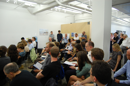
[Audience discussion during DredgeFest; photo by Nicola Twilley.]

One of the primary reasons that mammoth has been relatively quiet this year is the effort that Stephen and I, as two of the four current members of the Dredge Research Collaborative, have put into organizing DredgeFest NYC.  We did this with no small amount of assistance from our generous hosts, Studio-X NYC, and, thanks to the latest component of that assistance, a full video archive of the symposium is now available. (The other component of the event, the boat tour, was recently covered by The Atlantic Cities here.)

Below, you’ll find the video archive of the symposium that I mentioned.

Before getting to that, though, I suppose this is also an appropriate point to talk briefly about why we organized DredgeFest NYC.

When we began our work as the Dredge Research Collaborative, we began with the intention of producing and publishing speculative design projects that would demonstrate the value that landscape architects and other designers might bring to the aqueous landscapes of dredge. As our initial projects developed and we began to enter into conversations with the engineers, corporations, and agencies that currently are responsible for shaping those landscapes, we realized that there were two major barriers to design participation in these landscapes. First, dredge is an invisible infrastructure. It is essential to economic and environmental processes in nearly every contemporary estuarine city, but it is rarely a topic of public conversation. Second, though there is a growing interest in such landscapes within landscape architecture, that interest has remained primarily speculative, in large part because working relationships between designers and those actors with actual agency in the landscapes of dredge simply do not exist.

DredgeFest is our effort to grapple with these problems. By organizing public events, we are seeking to open up a public conversation about the dredge cycle, at once documentary and speculative, while using the events as an opportunity to build connections between disparate communities. Thus while we were thrilled by the diverse group of panelists who agreed to join us and the even more diverse audience who attended DredgeFest NYC, we were probably even more excited to see specific connections occurring between the design community and the dredging community, like the Army Corps engineer who approached one of our collaborators, Gena Wirth, after the event, excited about the mapping work she had done with us and hoping that she would be interested in expanding on that mapping work in collaboration with the Corps.

We think that this kind of cross-pollination is not only exciting, but essential. This week’s events have emphasized and underlined — in tragic fashion — the importance of designing urban littoral environments, of recognizing and meeting the challenges that rising and warming seas will pose to coastal cities in coming decades.

DredgeFest NYC: Video Archive
The first video, which contains an introduction to the event delivered by Brett and I, is embedded immediately below this paragraph. Below the first video, you’ll find the schedule as a list of talks and panels, with links to the video for each presentation or panel. (A full list of the videos can be found here, in Studio-X NYC’s own video archive.)

Dredge and the Anthropocene
We introduced the idea of dredge as a process that is interconnected with a much larger regime of human sediment handling practices, and examined ways that humans act as geologic agents.

Lisa Baron (USACE): Dredging and Dredged Material Management in NY/NJ Harbor
Andrew Genn (NYCEDC): The Beneficial Reuse of Dredge
Roger Hooke (University of Maine): How Humans Have Shaped the Landscape

Panel: Baron, Geen, Hooke, and Michael Ezban (Vandergoot Ezban Studio)

Circularity and Feedback
We examined the current evolution of the handling of sedimentary resources from 20th-century linear industrial models towards 21st-century methods that create cycles, positive feedback loops, and resilience in the face of contemporary environmental challenges. This section featured leading practitioners who explained how their work participates in and even accelerates this paradigm shift.

Bill Murphy (e4sciences): Geophysical Imaging for Sustainable Engineering – NY Harbor Deepening
Douglas Pabst (EPA): Sediment Management in NY/NJ Harbor
Edgar Westerhof: Green Solutions With Geotextile Tubes – a Dutch Perspective
Vicki Ginter (TenCate): TenCate Geotube Technology
Catherine Seavitt Nordenson (Catherine Seavitt Studio, CCNY): Adaptive Sediments – Dredge and Drift

Regeneration and Public Participation
We examined the emergence of dredge as a resource for environmental regeneration, like the current restoration of island wetlands within Jamaica Bay using dredged material from channel deepening projects. This section also highlighted the grass roots of dredge, with a panel of practitioners who enable public participation through their work.

Kate Orff (SCAPE, Columbia GSAPP): Future Landscape – Remaking New York’s Harbor
Phillip Orton (Stevens Institute of Technology): Guiding Coastal Adaptation with Hydrodynamic Modeling

Panel: Orff, Orton, Dave Avrin (NPS), Hans Hesselein (Gowanus Canal Conservancy), and Debbie Mans (NY/NJ Baykeeper).

The list of people that to whom we owe thanks for making DredgeFest possible is rather long. As mentioned before, we were hosted by Columbia University GSAPP’s Studio-X NYC — Nicola Twilley, Geoff Manaugh, and Carlos Solis. We were supported by the generous sponsorship of Arcadis, TenCate, and TWFM Ferry/American Princess (the last of which was the boat that took us out into the harbor — we can’t recommend Tom Palladino and the crew highly enough), making the event financially plausible for us as organizers. Alex Chohlas-Wood and Ben Mendelsohn put together the event trailer that we posted in early September, and are working on a longer follow-up that is sure to be fantastic. Seth Denizen and Gena Wirth contributed original maps and drawings to the exhibition that greeted attendees at the door, which I intend to post about in more detail soon. It was also extremely rewarding to see everyone who turned out, on both days, to share our enthusiasm for and belief in the importance of understanding and designing landscapes of dredge. Finally and perhaps most importantly, we were thrilled by the enthusiasm and efforts of the speakers and panelists, without whom there quite literally would have been no event.

palletized


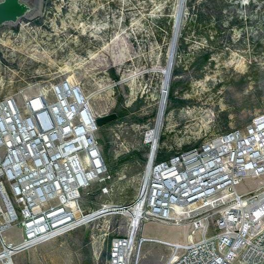
[Massive warehouse districts both east and west of I-35 in Laredo, Texas, filled with goods shipped across the Mexican border.]

Tom Vanderbilt, with a short history of the pallet, one of those logistical objects whose dimensions and properties format much of the space we live in, from store shelves to exurban warehouse districts:

For an invisible object, [pallets] are everywhere: there are said to be billions circulating through global supply chain (2 billion in the United States alone). Some 80 percent of all U.S. commerce is carried on pallets. So widespread is their use that they account for, according to one estimate, more than 46 percent of total U.S. hardwood lumber production.

Companies like Ikea have literally designed products around pallets: Its “Bang” mug, notes Colin White in his book Strategic Management, has had three redesigns, each done not for aesthetics but to ensure that more mugs would fit on a pallet (not to mention in a customer’s cupboard). After the changes, it was possible to fit 2,204 mugs on a pallet, rather than the original 864, which created a 60 percent reduction in shipping costs. There is a whole science of “pallet cube optimization,” a kind of Tetris for packaging; and an associated engineering, filled with analyses of “pallet overhang” (stacking cartons so they hang over the edge of the pallet, resulting in losses of carton strength) and efforts to reduce “pallet gaps” (too much spacing between deckboards). The “pallet loading problem,”—or the question of how to fit the most boxes onto a single pallet—is a common operations research thought exercise.

Pallet history is both humble and dramatic. As Pallet Enterprise (“For 30 years the leading pallet and sawmill magazine”) recounts, pallets grew out of simple wooden “skids”, which had been used to help transport goods from shore to ship and were, essentially, pallets without a bottom set of boards, hand-loaded by longshoremen and then, typically, hoisted by winch into a ship’s cargo hold. Both skids and pallets allowed shippers to “unitize” goods, with clear efficiency benefits: “According to an article in a 1931 railway trade magazine, three days were required to unload a boxcar containing 13,000 cases of unpalletized canned goods. When the same amount of goods was loaded into the boxcar on pallets or skids, the identical task took only four hours.”

Read the full article at Slate.

event horizon


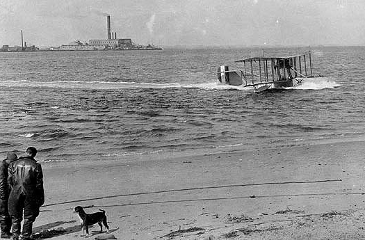
[A seaplane taxis in Jamaica Bay, 1918, with Barren Island in the background; source.]

I recently contributed a short piece to the excellent Fulcrum. The piece begins with a very short version of the bizarre history of Dead Horse Bay and Barren Island — about which I had to leave out eccentric anecdote after eccentric anecdote, such as the night that an entire horse-rendering facility and the horse-meat therein spontaneously combusted, which is perhaps the one that most succinctly encapsulates the alien quality of that ragged fringe of turn-of-the-century New York City — and then it segues into a series of questions about the future of our artificial geologies that may be familiar to any readers who endured my halting and half-formed delivery of these same thoughts on the DredgeFest boat tour. So beginning with the history:

Approximately sixteen kilometers southeast of Manhattan, the southern coast of Brooklyn wraps north along Floyd Bennett Field — a former airfield turned derelict-littered national park — skips across Plumb Beach Channel, and turns west. The small body of water inside this curve is Dead Horse Bay, named for the daily shipments of dead horses it once received from Manhattan. There, on Barren Island, a tight-knit community of immigrants operated an industrial age predecessor to Agbogbloshie, Guiyu, and Chittagong, recycling growing Manhattan’s waste in squalorous conditions. In a city possessed of an entirely different metabolism than modern cities, that waste amounted to an incredible quantity of dead and dying matter, processed in factories, smelters, bone-boilers, guano plants, and open piles. This fetid surplus was converted into an array of chemical products — glycerin, glues, fertilizers, oils — and exported to Europe.

If you want to get to the questions, you’ll want to click through to Fulcrum

Like most issues of Fulcrum, the issue my piece appears in (#53) has a theme (the Anthropocene) and pairs two authors on that topic (for #53, the other author is Seth Denizen, who contributes a short tale of holes, absence, and soil taxonomies).

Dan Hill recently wrote a short post on Fulcrum, giving it “top marks” for “pushing an agenda and pushing a format in unison, and [doing] both rather adeptly”. Agreed.

“a map for what?”

Shannon Mattern, writing “about material networks that span continents… and the strategies we devise to comprehend their scale and composition”:

What is the “aftermath” of the touring, the mapping, the listening and smelling, the playing of games? The promises to “make visible the invisible” and thereby “raise awareness” are far too often regarded as ends in themselves. The point of such exercises isn’t merely to make user-citizens “aware” of the complexity of the infrastructures that they’re so reliant upon. So now you know where your Internet comes from: now what? We should perhaps also aspire to raise bigger, “deeper” questions regarding the unique ontological nature of these systems and our place within them: where do they reside on the spectrum between the material and immaterial, the empirical and theoretical, the place-bound and the placeless, the local and the global, the past and present and future, the immediate now and the long now?

And perhaps, ultimately, we should aim to direct that “awareness” into something with “material consequences,” to borrow Nato Thompson’s phrase – something that “produce[s] effects…on the ground,” to echo Scott. There has of course been much debate over the effectiveness of “consciousness-“ or “awareness-raising” art, design, and pedagogical projects, including “critical spatial practice.[13]

This, I think, is an important question (though it is perhaps unfair of me to refer to that bundle of directions as a singular “question”). It also suggests one of the reasons that I think it extremely useful for mapping and revelatory practices to take place within the context of design disciplines, like architecture and landscape architecture — however weak the vocabulary and paths for translating awareness into “material consequences” may seem and indeed, at least at times, be within the design disciplines, at least they exist, and don’t need to be built from scratch.

petrochemical america


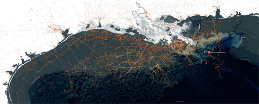
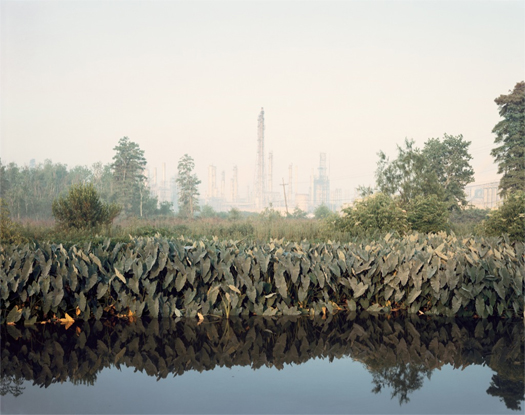
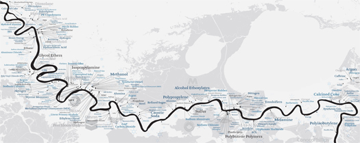
[From the top: diagram by SCAPE of off-shore oil facilities in the Gulf; Richard Misrach’s “Roadside Vegetation and Orion Refining Corporation, Good Hope, Louisiana, 1998” ; diagram by SCAPE of the various chemical products manufactured and refined in “Cancer Alley”. All from Petrochemical America, and visible at a higher resolution in this gallery at the New Yorker.]

If you’re in New York in the next week or so, you might want to catch one of the several events related to the launch of photographer Richard Misrach and landscape architect Kate Orff’s new book, Petrochemical America, which “depicts and unpacks the complex cultural, physical, and economic ecologies along 150 miles of the Mississippi River from Baton Rouge to New Orleans, an area of intense chemical production that first garnered public attention as “Cancer Alley” when unusual occurrences of cancer were discovered in the region”.

The several events include a lecture and book signing at MoMA this Thursday (6:30 pm — RSVPs are apparently required and available through Aperture), an opening reception at Aperture Gallery this Friday evening (from 6 to 8), and a panel next Tuesday (25th), also at Aperture Gallery. The work from Petrochemical America will be exhibited at Aperture until October 6, so even if you miss these events, you can still catch the exhibition.

And of course — Kate will also be a member of the very exciting line-up we have scheduled for DredgeFest NYC next Friday (the 28th), though the topics of conversation will be a bit closer to New York itself.

a short video about dredge

Videographers Alex Chohlas-Wood and Ben Mendelsohn are among the many talented people who are helping us put together DredgeFest NYC, and they’ve just released this short trailer for the event.

If you’re hoping to join us for the harbor tour — and hopefully the peak at a few landscapes of dredge that Ben and Alex have provided will whet appetites for exactly that — note that tickets are on sale but are limited.

dredgefest nyc


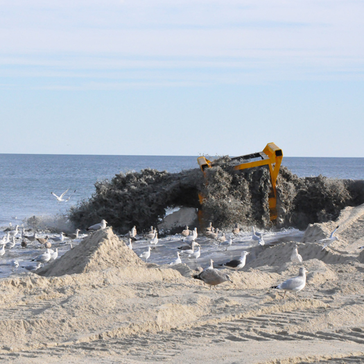
[Beach nourishment in Monmouth, New Jersey. Photo: USACE.]

A few months ago, I posted the live interview that the Dredge Research Collaborative (Stephen, Brett Milligan, Tim Maly, and myself) did with Geoff Manaugh and Nicola Twilley at Studio-X NYC. Both at that event and in the short post I did, we promised that we’d be back to New York in the fall for a longer event — a festival of dredge.

We’re pleased to announce that DredgeFest will be Friday, September 28th, and Saturday, September 29th.


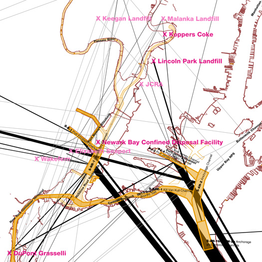
[A tangled web of exported sediments: mapping the transfer of silt, sand, clay, and rock from dredge sites in New York and New Jersey Harbor, from 2009 to early 2012. Draft image: Dredge Research Collaborative.]

Dredging — the mechanized transport of underwater sediments — is one of the most primal of the infrastructural support systems underlying the modern metropolis: huge barges, hoses, and shovels locked in constant combat with the entropic pull of gravity. Through dredging, we act as geologic agents — accelerating and decelerating the movement of silts, sands, and clays.

DredgeFest will both explore dredging as an industrial activity central to the functioning of an estuarine metropolis like New York City, as well as circle outward from dredge to a variety of linked landscapes and processes, from oyster-farming to anthropogenically-accelerated erosion to retrofitting New York’s coastal edges for climate change adaptation.


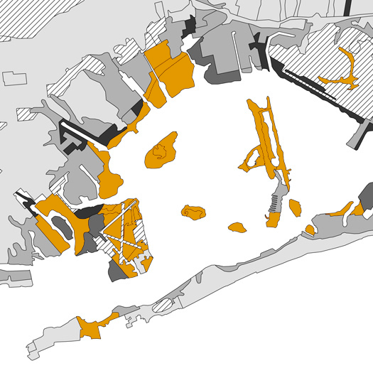
[Anthrosols in New York: dredge and other fill around Jamaica Bay. Draft map by the Dredge Research Collaborative using data from the NYC Reconnaissance Soil Survey, which is an amazing dataset — part of the world’s first urban soil survey to explicitly focus on the classification of anthrosols.]

On the 28th, we’ll spend the afternoon at Studio-X (180 Varick Street), for talks and panels discussions that will bring together corporate practitioners, government agencies, designers, scientists, theorists, and industry experts. We’ll be talking about dredge and the Anthropocene — how human sediment handling practices are helping to shape a new geologic era; hearing about the current evolution of the handling of sedimentary resources from 20th-century linear industrial models towards 21st-century methods that create cycles, positive feedback loops, and resilience in the face of contemporary environmental challenges; looking at dredge as a regenerative resource; and examining the role of public participation in the landscapes of dredge. We’re quite excited about the line-up we’ve developed for that afternoon, which includes designers Kate Orff and Catherine Seavitt; representatives of public agencies like the USACE, EPA, and NPS; Eric Sanderson, author of Mannahatta; corporations involved in sedimentary New York; geologist Roger Hooke; and more.


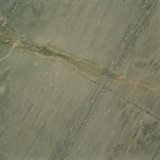
[Saltmarsh restoration on Yellow Bar in Jamaica Bay. Aerial image by Gena Wirth and Rob Holmes, Public Laboratory and the Dredge Research Collaborative.]

Then, on Saturday, having talked about the past, present, and future of New York’s dredge landscapes, we’ll spend the afternoon on a boat, touring littoral New York, visiting sites from active dredging in the Ambrose Channel, where the Army Corps is preparing for the imminent arrival of exceptionally large Post-Panamax container ships, to heavily-eroded Plumb Beach, to restoration projects under way in Jamaica Bay.

Unlike the symposium on Friday afternoon, which will be free and open to the public, Saturday’s boat tour is ticketed. Tickets are available through Brown Paper Tickets, at a reduced rate of $34 through September 6.

Much more detail is available at the DredgeFest website.

brickstarter

Tim Maly interviews Bryan Boyer and Dan Hill about their new project, Brickstarter:

Anyone who’s ever tried to get some change to their neighborhood done knows the pain of fighting through a bureaucracy that tends to dampen even the most enthusiastic of spirits. “This activism often occurs on the periphery, in the legal gray areas where there’s nothing to mandate a definitive ‘no’, but also no clear process for how to get an initiative off the ground,” says designer Bryan Boyer.

Together with a team of designers, Boyer and partner Dan Hill, the Strategic Design Leads at Sitra, the Finnish Innovation Fund, are working to solve this problem with a service they’re calling Brickstarter.

Like its namesake, Kickstarter, Brickstarter is a platform for making it easier for DIY projects to get underway. People can propose projects, with all the usual trappings of video pitches, text updates, funding goals, and deadlines. The big difference is that it is focused on projects run at a neighborhood level, to be conducted in public, and to be connected with civil services and bureaucracy.

For a lengthier discussion of Brickstarter — which I think is incredibly promising, particularly in its focus on illuminating regulatory structures and documenting paths that projects can take through ‘dark matter’ — I recommend Alexandra Lange’s “Against Kickstarter Urbanism”, Bryan and Alexandra’s comments on that piece, and Bryan’s reply on the Brickstarter blog, “For Involved Urbanism”.

the commonwealth approach

[The following is the text and (a slightly condensed set of) slides from the presentation that Laurel McSherry and I gave at the Drylands Design Conference in late March. The presentation walks through our highly speculative proposal for the reconfiguration of the political geography of the United States to better conform to the spatial distribution of various water resources, such as rivers, aquifers, and man-made infrastructures. I think the proposal is most interesting if it is understood as a speculative update of Powell’s famous 1890 “Map of the Arid Region of the United States, showing Drainage Districts” — with the emphasis being on updating a map, rather than constructing a policy proposal.]

Our work – which we call the commonwealth approach – takes as a starting point Powell’s call to align the nation’s political landscape with its natural resource base ––specifically, the creation of a system of self-governing entities whose boundaries correspond to the natural drainage areas of principal rivers.

Taken together, the five components of our work –– commonwealths, territories, capitals, trans-border regions, and communal aquifers –– reassert the fundamental importance of surface and ground water resources in land planning, and by exploring the reconfiguration of political boundaries, calls out some of the problems with the current system from a water resources point of view.

However, because conditions now are so different than at the time of Powell’s writings, merely redrawing political boundaries to watershed borders still leaves numerous conflicts between political geography and water resource management.

As a provocation, our work illustrates some of the ways that Powell’s framework is inadequate for coping with contemporary problems.

We began by looking at how our nation’s political geography currently relates to water – and quickly discovered a key problem: state boundaries run across and cut up water resources.

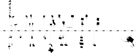
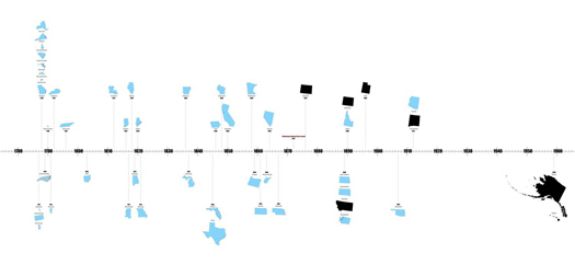
This slide illustrates the 170-year window for the creation of the current 50 states…

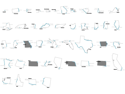
…. of which all but 6 utilized rivers or portions of rivers as natural boundaries.

this was due, in part, to the use of rivers in defining the territories from which the states ultimately emerged.

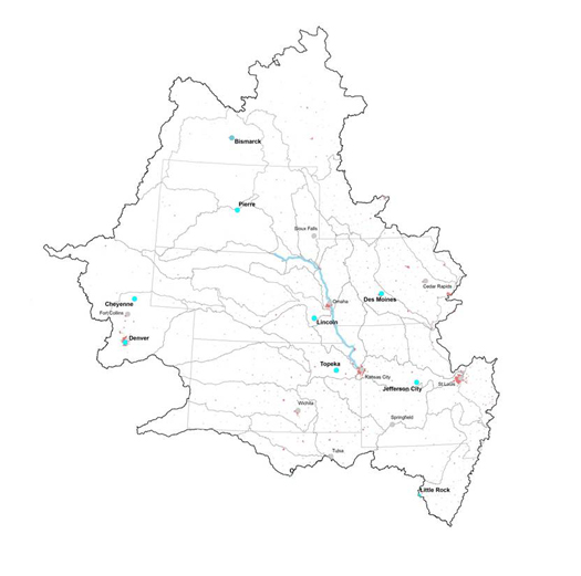
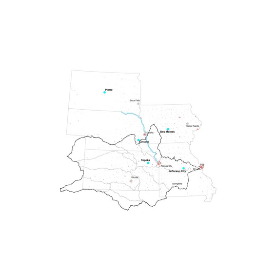
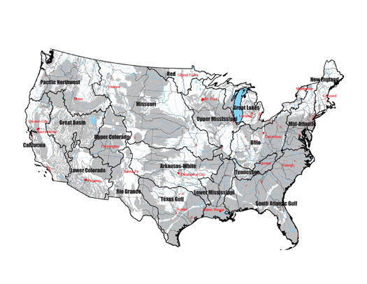
From these forty-four river-bounded states, we selected five (gray, in the image above) –– South Dakota, Nebraska, Kansas, Iowa, and Missouri –– all of whom employ portions of a stretch of the Missouri River, and compared relationships between the their political boundaries and the boundaries of their individual hydrologic subregions.

Because rivers fall in the center of drainage basins, their use as boundaries reinforces a conception of water as a liner resource –– a conception which fails to account for the actual resource geography of water.

A commonwealth approach –– which aggregates second-order USGS watershed units –– is a first-pass at aligning political geography with the movement of surface water.

Resulting in a configuration of eighty-six commonwealths in the lower forty-eight states.

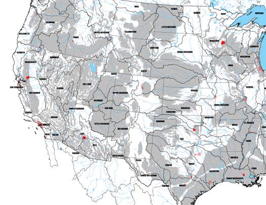
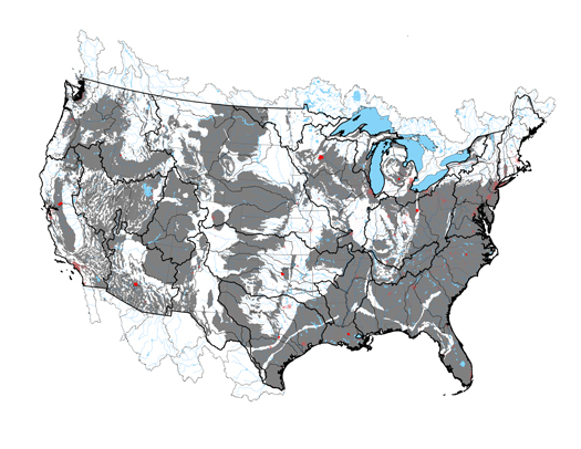
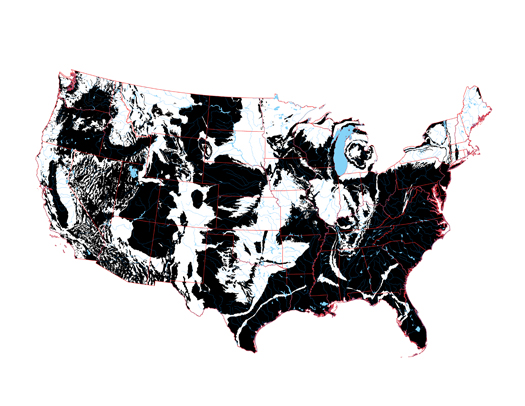
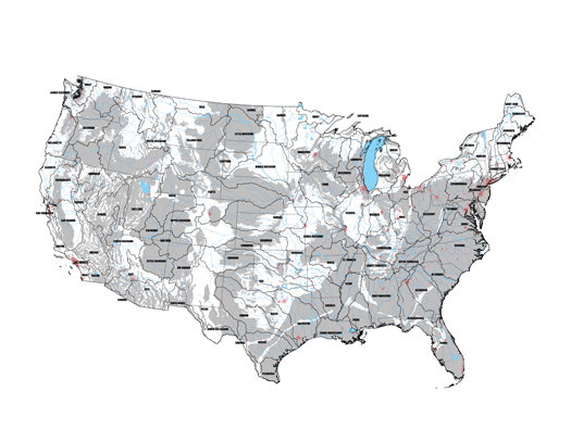
While Powell’s call for commonwealth governance may have gone unheeded, we can expect that he would be most pleased by the degree to which another of his proposals — for the “redemption” of what he called “worthless lands” through agriculture and the engineered transport of water — has been accomplished. Above, a map produced using USGS data which tracks the presence of “watershed modifications” — things like irrigation, dams, and canals — across the United States; what is immediately evident is that watershed modification is a nearly ubiquitous condition.

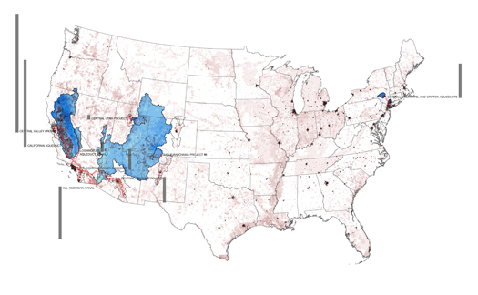
This condition is produced by a series of infrastructures — wells, reservoirs, dams, aqueducts, canals, pipelines, tunnels, and pumping stations — which, together, create artificial hydrology and, by extension, artificial watersheds.

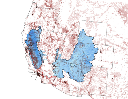
The artificial watershed of Los Angeles, which is constructed primarily by the California, Los Angeles, and Colorado River Aqueducts, provides a particularly instructive example, permitting us to compare an intrajurisdictional transfer (the Los Angeles Aqueduct) with an interjurisdictional transfer (the Colorado River Aqueduct).

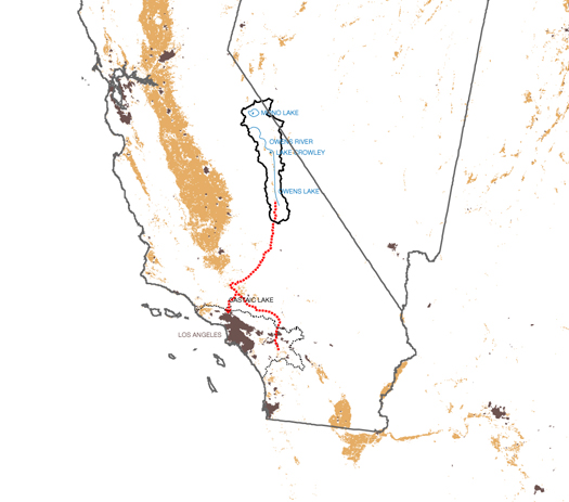
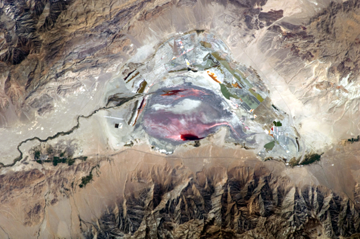
The Los Angeles Aqueduct taps the Owens River and Mono Basin, transferring water from one basin to another, but within the same state —


[Photograph: ISS Expedition 28 (NASA Earth Observatory]

at the expense of the health of the donor watershed.

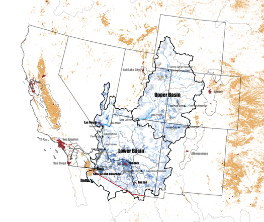
But in the Colorado River Basin — which implicates not just California, but a total of seven American and two Mexican states —

a complex set of agreements and political maneuverings has arisen. Consequently — while we don’t want to oversimplify — it is hard to argue that upstream interests, both human and non-human, are not better represented on the Colorado than the Owens.

Thus we can say that one benefit of political boundaries may be — somewhat counter-intuitively — the difficulties they create.

Both the commonwealths and the larger political entities shown here, the territories, have been strategically drawn to do this.

Commonwealths provide a decentralized political geography, constituting a barrier to centralized strategies for dealing with limited water resources and encouraging instead the relative growth of decentralized tactics — localized, place-specific, and less energy-intensive alternatives.

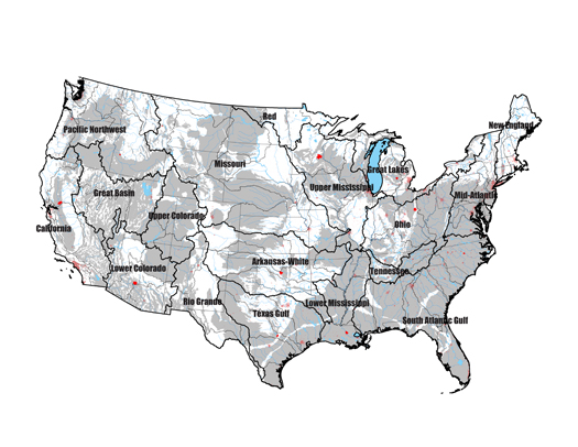
The territories we propose, which are formed by aggregating commonwealths to recognize the boundaries of major river basins, reinforce this effect by recognizing and regulating the special case of interbasin transfer and the enormous impact of infrastructures on Arid Lands hydrology.

(The territorial boundaries derive from the USGS first-level of watershed classification, which divides the nation into twenty geographic areas containing the drainage area of a major river (e.g. the Missouri Region) or the combined drainage areas of a series of rivers (e.g. the Texas-Gulf).

Another problem we see is that of distance and difference. One of the fundamental contentions of our project is that the political geography of the United States — the location of bureaucracies, the subdivision of the nation into smaller units, the position of symbolic and actual power centers like the Capital — biases decision-making. This political geography constitutes an organizational architecture that precedes, constrains, and even produces site architecture.

In particular, the position of the federal government in the District of Columbia, so far east of the 100th Meridian, produces a bias against understanding the full consequences of the aridity of the West.

In response, we propose the distribution of the functions of the federal government to a set of 19 territorial capitals. The driest existing state capital in each territory would become the new territorial capital — reversing this bias without requiring the construction of new capitals.

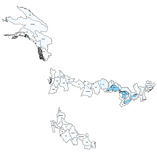
The current political geography also overlooks the fact that watersheds do not stop at international borders. Trans-border regions aggregate North American watershed units into a series of 36 international commonwealths –– requiring, in turn, the creation of trans-national entities to negotiate for the joint interests of America and its contiguous neighbors.

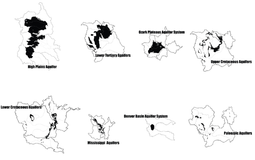
The final dimension of our work –– communal aquifers –– recognizes that subsurface water resources traverse state, national, as well as commonwealth borders.

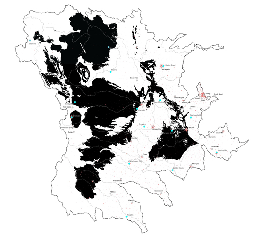
Returning to the Missouri 5, we learn that redrawing states into commonwealths still leaves conflicts between political geography and water resource management.

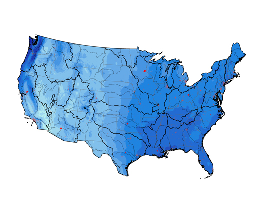
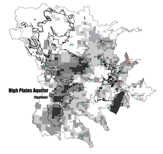
In the absence of oversight body or management agreement, these trans-boundary resources (such as the eight communal aquifers illustrated here in this intensity of withdrawals map) will too be subject to the tragedy of the commons.

Our aim with this project, then, has been to construct a series of maps that function as a visual primer in the relationship between hydrology and political geography in the United States. In particular, taking the notion of watershed-based governance — which has existed at least since Powell’s proposal, and which has been implemented in a variety of ways in North America, from agreements like the previously-mentioned Colorado River Compact to agencies like the Columbia River Basin’s Northwest Power and Conservation Council — and indicating some of the other hydro-geographical conditions that contemporary water governance must account for, from artificial watersheds to groundwater withdrawal.

[This proposal was produced with the support of a research award from the Drylands Design Competition as well as Virginia Tech students Becky May and Alex Gonski. Barry Lehrman‘s assistance was also invaluable in researching artificial watersheds. The conference and the competition were both organized by the Arid Lands Institute at Woodbury University, whose directors are Peter and Hadley Arnold.]

very long radio waves


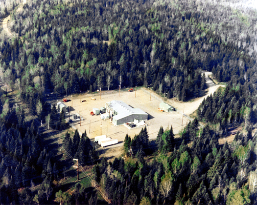
[
Image via Panoramio user subdefective.]

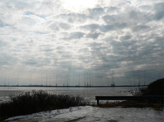
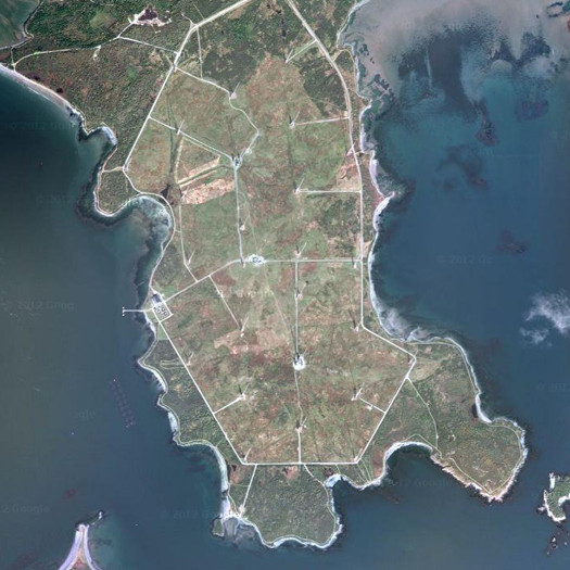
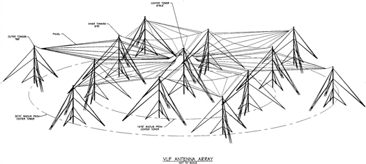
VLF Transmitter Cutler is a “very-low frequency” radio station on the north-eastern edge of Maine’s seacoast operated by the US Navy, primarily for the purpose of communicating with submarines.

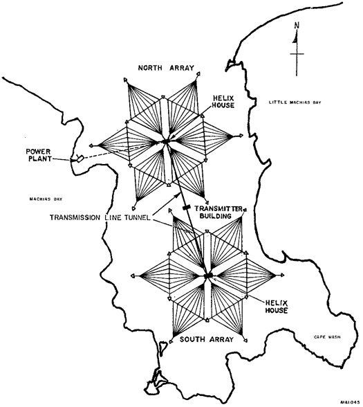
The perfectly geometric arrangements of antennas and support cables both recall the hexagonal logic of cellphone towers and suggest some kind of weird radio-wave sublime, a technological landscape that could easily — in the imagination of the lonely boater following the coastline north towards Nova Scotia — be read as the quivering inverse of the National Radio Quiet Zone, as permeated by radio waves as that zone is empty. (Someone should send Simon Norfolk out to both to do a positive/negative-themed follow-up to his Ascension Island series.)


[Diagrams of VLF Transmitter Cutler, via Wikipedia.]

While very-low frequency radio waves can be used to communicate with vessels that are relatively close to the surface of the ocean, as the waves generated by VLF Transmitter Cutler are, radio waves with even longer wavelengths (and lower frequencies) called “extremely-low frequency” radio waves were once thought to be the future of communication with deeply-submerged submarines.


[Clam Lake ELF, via wikipedia.]


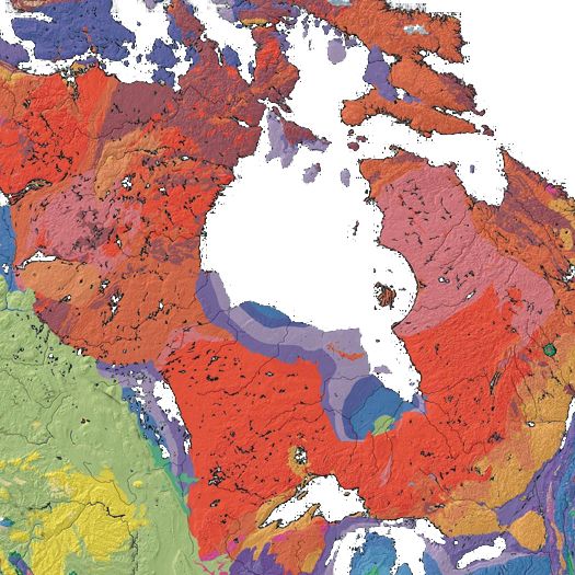
[Geologic map of the Canadian shield, via wikipedia.]

Early in his first term, President Reagan approved the construction of two ELF transmission stations, which operated from 1989 to 2004 and stretched a combined eighty-four miles of antennae through remote forests near the Wisconsin-Michigan border. As incredibly long as those antennas are, though, the Clam Lake and Republic Navy Radio Transmitters were significantly scaled-down versions of the Navy’s original proposal, “Project Sanguine”, which would have stretched six thousand miles of antenna through the Laurentian Plateau (a vast geological shield of igneous rock beneath much of the northern United States and Canada, which happens to be perfectly suited to spreading extremely-low frequency radio waves) in a massive grid, transforming an astonishing forty percent of the state’s bedrock into a massive radio transmitter. Wisconsin herself, singing submariners to sleep.

[VLF Transmitter Cutler seen at the wonderfully-matter-of-fact but unfortunately defunct geo-blog Manufactured Landscapes, which I could spend days browsing.]

the new modulated world of invisible fields


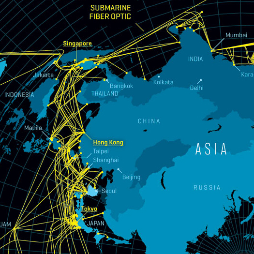
[A portion of Nicolas Rapp’s map of the internet for Fortune magazine.]

Writing for Quaderns, Kazys Varnelis argues for an infrastructural urbanism that not only embraces and seeks to design (or design with) infrastructure, but also imagines new infrastructures “more appropriate to network culture”:

But we have not gone far enough yet. The Deleuzian modulations that govern our society are increasingly invisible. Like it or not, just as industry once took over from agriculture, finance has come to dominate economies across the globe. We all need to eat, we all need to dress in clothes and inhabit houses, but economies are increasingly governed by the financial sector and its demands. Nor does finance find itself easily grounded: trading floors across the world are emptying out, unable to keep up with the ultra-rapid movements of liquidity in anonymous facilities such as the NYSE Euronext installations in Mahwah, New Jersey, and Basildon, a suburb east of London.

The financial services sector reflects our condition of living in Hertzian space—the cloud of electromagnetic signals that surrounds us—as much as in physical space. Take a look at a city street: passers-by relentlessly text each other, listen to music on their iPods, navigate with geolocative devices or talk on wireless phones.

Physicists tell us that electromagnetic forces are far more powerful than gravity (a tiny magnet holds up a paperclip against the entire gravity of the Earth). As I write this, destroyed nuclear power plants smoulder on Japan’s Pacific coast, carving out vast exclusion zones across the island nation’s inland territory. Proponents of infrastructural urbanism often cite flocking conditions exhibited by birds, marine mammals and other animals as examples of the sort of effects they wish to achieve, embracing both the individual and the collective, autonomous agency and massive change. But these behaviours are not made solely according to a genetically encoded rule set. Rather, they are done with reference to the invisible but very real electromagnetic world. Even though we cannot directly perceive the electromagnetic spectrum, the way we have reshaped its modulations impacts the behaviour of such creatures. It is time for architects to understand that the structures of infrastructural modernity are just so many ruins and, in conceiving of new infrastructures for the millennium, to learn how to embrace the new modulated world of invisible fields.

Read the full article at Quaderns.

collisions


[
Via Pete Brook at Wired, Mary Lydecker’s collages splice together scenes from vintage postcards to create images of Pruned-worthy vacation locales (like the infrastructural beach above) and bundles of skyscrapers improbably close to dams, mountains, and rivers, as if the cities they belonged to were crashing suddenly into some unorthodox planner’s feverishly strict urban growth boundary.]

[More of Lydecker’s work can be found at her website.]

landscape ontology


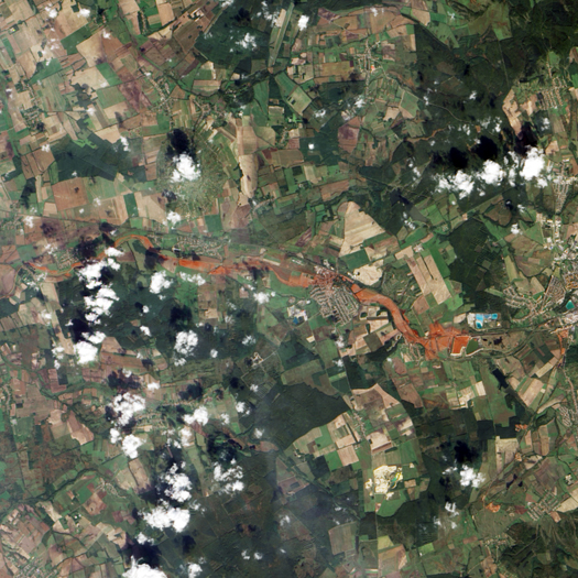
[A landscape in the process of becoming a different landscape:

In late 2010, the waste reservoir of a Hungarian aluminum oxide plant burst, releasing millions and millions of gallons of caustic red sludge. The meter-high toxic mudslide quickly moved downhill through two nearby villages, burying buildings, poisoning fields and killing 10 people.

The image above is from NASA Earth Observatory, while the descriptive quote is from a recent NPR story on the striking photographs of Spanish photographer Palindromo Meszaros, which capture the otherworldly post-mudslide landscape, and are well-worth a look.]

Brian Davis interviews Graham Harman on “landscape ontology” (Harman is speaking in the following quote):

There is a suburb of Iowa City called Coralville. While there is no coral reef anywhere near this suburb today, you will easily guess that there was coral here in the distant past: during the Devonian Era. During the 1993 Iowa floods (a precursor to the far more disastrous floods of 2008), water washed over the Coralville Dam and ripped all the soil from the nearby campsite, exposing a neo-Devonian fossil bed filled with creatures of almost Lovecraftian monstrosity.

What is the connection between Iowa in 1993 and the swarming neo-Devonian monsters of 360 million years ago? You can’t really say that “Iowa” forms the connection, and not just for the reason that Iowa as a political unit did not exist at that time. You can’t even say that the two things happened on the same physical landscape, since Iowa was apparently covered by sea at the time. Indeed, when I look at the position of the continents in late Devonian times I cannot easily determine where Iowa would have been on the map.

In a sense, then, the fossils themselves are the landscape. It is the fossils that link the Coralville of 1993 with the living creatures of the Devonian Era. I would say that a landscape is any object that links a wide variety of other objects that all use it as a mediator. A landscape is like a “wormhole” linking different times and different places or different classes of living organisms and inanimate objects. Through landscapes we are linked to the Native Americans who left a spearhead buried in what is now my parents’ front yard, as well as to the deer, moths, beetles, and viruses that inhabit the woods surrounding their yard, and with which I have only incidental contact.

The italics here are mine, because I find this definition of landscape quite fascinating — in part because of the great breadth of things that it permits us to understand as landscapes. If a fossil can be a landscape, what can’t? Landscape becomes a way of understanding objects rather than a specific class of objects, which is not unlike the argument I’ve made elsewhere that “infrastructural” (in which “infrastructure” becomes a specific kind of behavior that nearly any object can assume in relation to at least some other objects) is a more significant category than “infrastructure” (the collection of things immediately recognizable as infrastructures — roads, bridges, fiber-optic cables, wastewater treatment plants, and so on). As another example of the width of Harman’s definition: a building could easily be understood as a landscape, if, for instance, it serves as the linkage between a family of mice, a night watchman several decades ago who lost the key to the basement closet where those mice now nest, and the Gilded Age family whose wealth paid for the construction of the building.

I also rather like what this suggests about the landscape architect: that a key characteristic of landscape architecture as a pattern of thought is its propensity for understanding linkages between diverse and seemingly-unrelated phenomena at differing scales of time and space — how Devonian geologic movements affect contemporary vegetation patterns, how a measurement standardized in 1675 could determine the urban form of Dutch coastal cities in the twenty-first century, or how the arrangement of paths within a bounded site affects circulation within the surrounding city.


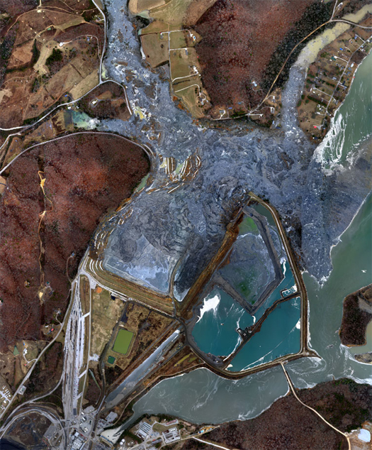
[A second landscape becoming yet another landscape: the coal ash slurry spill at the TVA Kingston plant in Tennessee, December 23, 2008 — one day after the spill. The spill released over five million cubic yards of slurry, covering the adjacent area in a coat of viscous sludge up to six feet thick. It was the largest such spill in American history. Image via wikipedia.]

I also enjoyed Harman’s thoughts on when a landscape becomes a different landscape:

“People have their graduations, weddings, and major awards; landscapes have their floods and explosions. When looking for the moments when a landscape became a substantially different thing, I would look for the moments when it entered into long-term symbiosis with some other thing— whether it be a human historic event, the intrusion of an invasive species, a cataclysmic physical change, or some other incident that marked the intertwining of the landscape with something else.”

It’s hard to read this and not be reminded of Manuel DeLanda’s co-option of terms from physics and mathematics like “phase transition”, “bifurcation”, and “far from equilibrium” in the introduction to a A Thousand Years of Nonlinear History:

If one allows an intense flow of energy in and out of a system (that is, if one pushes it far from equilibrium), the number and type of possible historical outcomes greatly increases. Instead of a unique and simple form of stability, we now have multiple coexisting forms of varying complexity (stable, periodic, and chaotic attractors). Moreover, when a system switches from one stable state to another (at a critical point called a bifurcation), minor fluctuations may play a crucial role in deciding the outcome. Thus, when we study a given physical system, we need to know the specific nature of the fluctuations that have been present at each of its bifurcations; in other words, we need to know its history to understand its current dynamical state.

…attractors and bifurcations are features of any system in which the dynamics are not only far from equilibrium but also nonlinear, that is, in which there are strong mutual interactions (or feedback) between components. Whether the system in question is composed of molecules or living creatures, it will exhibit endogenously generated stable states, as well as sharp transitions between states, as long as there is feedback and an intense flow of energy coursing throughout the system.

…much as a given chemical compound (water, for example) may exist in several distinct states (solid, liquid, or gas) and may switch from stable state to stable state at critical points in the intensity of temperature (called phase transitions), so a human society [or landscape!] may be seen as a “material” capable of undergoing these changes of state as it reaches critical mass in terms of density of settlement, amount of energy consumed, or even intensity of interaction.

There’s an interesting difference between the two metaphors being used to understand change in objects here: Harman uses a biological metaphor — symbiosis (a landscape becomes a different landscape when it adds a new symbiotic relationship) — and DeLanda uses a metaphor from physics — phase transition (where we might say a landscape becomes a new landscape when the aggregate input of changes reaches a certain threshold and tips the landscape into a radically different state). With the latter metaphor, change is detected by measuring the state of the landscape itself; with the former, change is detected by observing the kinds of relationships that the landscape has with other objects. (I shouldn’t push this too far, because DeLanda is also quite concerned elsewhere with relations — my point concerns the difference between these two metaphors, not a difference between DeLanda generally and Harman generally.)

My first reaction is that this suggests the importance of tracking relations to understanding (and thus to operating in and on) landscapes, which — given the centrality of mapping and drawing to understanding within both architecture and landscape architecture — in turn suggests that we’ll need to keep evolving more intricate and complex tools for mapping (and re-designing!) those relations. I suspect that doing so will require, at least in part, cross-breeding the kinds of maps and drawings we’re already comfortable making with examples from well-outside the fields, particularly examples that permit kinds of quantification and measurement that our current toolkit does not: topological maps re-inserted into measured space, material flow analyses, Odum diagrams, flow diagrams from industrial ecology, and so on.

[Read Davis’s full interview with Harman at FASLANYC. If you enjoy that interview, you might also enjoy this series of posts on Davis’s thesis blog: A Theory of Instruments, Radical Difference, and The Conceptual Triad.]

designing novel ecosystems


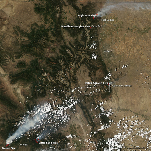
[Wildfires in the southern Rockies from space, June 23; via NASA Earth Observatory.]

A recent post on the current wildfires in the southern Rockies at the New York Times‘ Green blog reminded me that I had intended to excerpt an earlier editorial, also at the New York Times, which defended the notion of the Anthropocene as “the stage on which a new, more positive and forward-looking environmentalism can be built”:

Yes, we live in the Anthropocene — but that does not mean we inhabit an ecological hell. Our management and care of natural places and the millions of other species with which we share the planet could and should be improved. But we must do far more than just hold back the tide of change and build higher and stronger fences around the Arctic, the Himalayas and the other “relatively intact ecosystems,” as the scientists put it in their article.

We can accept the reality of humanity’s reshaping of the environment without giving up in despair. We can, and we should, consider actively moving species at risk of extinction from climate change. We can design ecosystems to maintain wildlife, filter water and sequester carbon. We can restore once magnificent ecosystems like Yellowstone and the Gulf of Mexico to new glories — but glories that still contain a heavy hand of man. We can fight sprawl and mindless development even as we cherish the exuberant nature that can increasingly be found in our own cities, from native gardens to green roofs. And we can do this even as we continue to fight for international agreements on limiting the greenhouses gases that are warming the planet.

The emphasis here (in the italics, which are mine) — on the possibility of designing novel ecosystems that perform better than the emergent novel ecosystems that will inevitably replace obsolete ecoystems unless we intervene — suggests a vast and unexploited territory for landscape architecture.

The post I mentioned earlier, on wildfire, brought this excerpt to mind for me because it describes the historical pattern of exactly one such obsolesence:

Using data from tree ring studies, scientists have reconstructed a history of fires in the Southwest. The wildfires of the past were frequent and massive, but they stayed close to the ground and mainly helped prevent overcrowding. Take 1748. “Every mountain range we studied in the region was burning that year,” Dr. Allen said. “But those were surface fires, not destroying the forest but just keeping an open setting.” Cyclical wildfires were the norm.

But beginning in 1900, when railroads enabled the spread of livestock, cattle devoured the grassy surface fuels and the fire cycle stopped. A decade later, a national policy of forest fire suppression formalized this new normal. Over the next century, forest density went from 80 trees per acre to more than 1,000.

Then in 1996, the climate emerged from a wet cycle into a dry one — part of a natural cycle for this region. Winters became drier. And “we immediately began seeing major fires,” Dr. Allen said.

With so many trees crammed into the forest, fires climbed straight to the canopy instead of remaining on the ground.

“These forests did not evolve with this type of fire,” said Dr. Allen. “Fire was a big deal in New Mexico, but it was a different kind of fire.” The result, he said, is that the species that now live there — ponderosa pines, piñon, juniper — cannot regenerate, and new species are moving in to take their place.

It seems quite noteworthy that the ecosystem which is becoming obsolescent — the dense conifer forest — is also a novel ecosystem of anthropogenic origin. The forest we are losing is as artificial as its replacement could ever be.

Dr. Allen’s final quote is also noteworthy, and would serve as a decent mantra for the environmentalist (or ecosystem-designing landscape architect) of the Anthropocene:

“Seeking to preserve existing systems is futile.”

[The authors of the editorial quoted above are Emma Marris, Peter Kareiva, Joseph Mascaro, and Erle C. Ellis.]

venue interview with edward burtynsky


[Edward Burtynsky’s “Drylands Farming #7” — farms in Monegros County, Aragon, Spain.]

Geoff Manaugh and Nicola Twilley recently posted an interview with infrastructural landscape photographer extraordinaire Edward Burtynsky, as a component of their latest project, the continentally-roaming Venue (self-described as a “portable media rig, interview studio, multi-format event platform, and forward-operating landscape research base”). In it, Burtynsky aptly describes his work as “looking for the disconnected landscapes that provide us with the materials we need to live, build, and do everything we do”, which suggests that his photography could be understood as an attempt to achieve the re-wiring of our understanding of the physical phenomenon of urbanization from a well-bounded object characterized primarily by some threshold of density towards an operative (lively, pulsating) material network whose dendritic tentacles reach deep into remote forests, sink into and carve out mountains, and even stretch across oceans. Which (beyond the immediate aesthetic impact of Burtynsky’s photographs, which can be awe-inspiring in large format) would explain why I am so fond of it.

[You can learn more about Venue here.]

zones and extrastatecraft


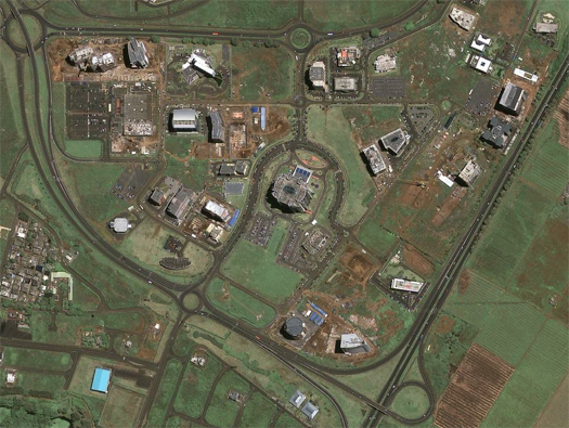
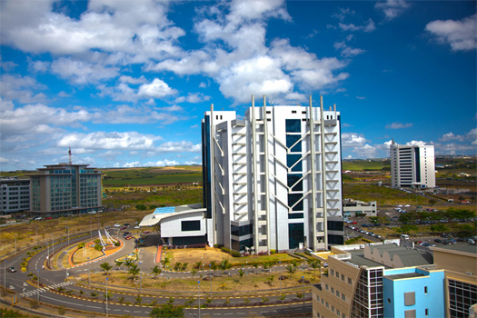
[A zone: Ebene Cybercity in Mauritius. As a bonus, Ebene is also an excellent example of the capacity of the Tubes to direct urban futures, as one of its prime selling points is that it sits at a landing point for the “the SAT3/WASC/SAFE sub-marine cable which links Southern Europe, Western and Southern Africa and South-East Asia”.]

Places has just published a fascinating piece from Keller Easterling, “Zone: The Spatial Software of Extrastatecraft”, which (appropriately) exports and reformats material from Easterling’s forthcoming Extrastatecraft. (Here at mammoth headquarters, Extrastatecraft is more or less guaranteed to be the most hotly anticipated book of whatever year it ends up coming out in, unless Keith Haddock finally gets around to updating Colossal Earthmovers.)

“Zone” is a brief history of the various kinds of “free zones” — “including free trade zones, foreign trade zones, industrial free zones, free zones, maquiladoras, export free zones, duty free export processing zones, special economic zones, tax free zones, tax free trade zones, investment promotion zones, free economic zones, free export zones, free export processing zones, privileged export zones and industrial export processing zones” — that have proliferated globally in both the 20th and 21st centuries, from the United States’ first free trade zone on Staten Island, to mid-twentieth century “export processing zones” like Manaus in Brazil and India’s Kandla Free Trade Zone, to Malaysia’s “Multimedia Super Corridor” or Ebene Cybercity on Mauritius. Expanding upon her earlier work’s contention that “diverse spatial types demonstrate the ways in which architecture has become repeatable and infrastructural” (read: Organization Space‘s “generic protocols for building offices, airports, houses, and highways”), Easterling argues that, with the zone, urbanism has also “become infrastructural”, repeatable, and is even metastasizing wildly:

“Today urban space has become a mobile, monetized technology, and some of the most radical changes to the globalizing world are being written, not in the language of law and diplomacy, but rather in the spatial information of infrastructure, architecture and urbanism. Massive global systems — meta-infrastructures administered by public and private cohorts, and driven by profound irrationalities — are generating de facto, undeclared forms of polity faster than any even quasi-official forms of governance can legislate them — a wilder mongrel than any storied Leviathan for which there is studied political response.

One of these meta-infrastructures is the phenomenon of the free zone — a highly contagious and globalized urban form and a vivid vessel of what I have termed extrastatecraft. A portmanteau meaning both outside of and in addition to statecraft, extrastatecraft acknowledges that multiple forces — state, non-state, military, market, non-market — have now attained the considerable power and administrative authority necessary to undertake the building of infrastructure.”

This seems correct — and the “highly contagious” spatial formats produced by these extra-state forces are perhaps all the more important as objects of architectural study when the public sector in the United States refuses to spend on infrastructure even as “the interest rates on 10-year treasury bonds just hit a 220-year low“, as the relative agency of extrastatecraft necessarily expands with every contraction of the state.

Read the full article at Places.

athabascan aereality

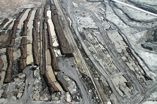
Business Insider‘s Robert Johnson has been touring various projects, sites, and landscapes in and around Canada’s Athabascan Oil Sands; the photographs he’s bringing back and articles he’s curating are a stunning mixture of the industrial sublime, raw instrumentality (such as: the world’s largest dump truck, and its forty-thousand dollar tires), and a visual testament to the scale of contemporary humanity’s geological agency. The photograph above is from Johnson’s aerial tour of the oil sands, which he undertook after being refused access to the mines on the ground. A full set of photographs — well over two hundred — can be seen on flickr.

atlas of suburbanisms


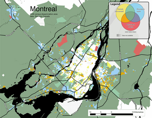
[“Montreal: Percentage of residents who drive to work, live in single-detached housing, and own their homes”, from Moos and Kramer’s Atlas of Suburbanisms.]

The University of Waterloo’s Atlas of Suburbanisms — a research project by the School of Planning’s Markus Moos and Anna Kramer — looks like a fantastic effort to understand Canadian suburbs on their own terms and as components of larger urban systems:

“…what if we mapped characteristics commonly believed to be telling of suburbs just to see where they actually occur? What if we went to the suburbs, figuratively and literately, and conducted research as if looking from one suburb to the other, or as if looking from a suburb toward the central city? The likely result is an understanding of suburbanism, and our cities more generally, that is richer and more diverse; an understanding that does not take for granted the political or historic development of cities as drawing concrete lines between what we believe is the suburban and the urban.”

To do this, the research relies on a shift from understanding suburbia primarily as a spatial format — defined by distance from the center of a city, by a certain level of density, or by particular ways of arranging streets and buildings — towards understanding suburbanisms as a kind of urbanity constituted by certain patterns of living: driving to work, gravitating towards demographic monocultures, retreating from public space towards semi-public and private space, owning rather than renting.


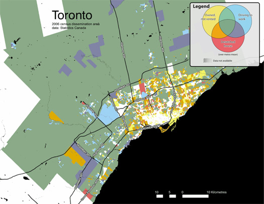
[“Toronto: Percentage of residents who drive to work, live in single-detached housing, and own their homes”, from Moos and Kramer’s Atlas of Suburbanisms.]

This is not a new idea, of course, as the authors of the Atlas acknowledge in referencing Henri Lefebvre.  (And the tradition of understanding urbanism “as particular ways of living” goes back to Louis Wirth’s Urbanism as a Way of Life, and Park and Simmel before him.)

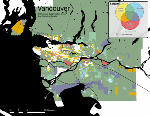
What is novel — to me at least — is the mapping work included in the Atlas, which extracts a set of variables from Canadian census data — on driving to work, home ownership, and detached housing — to create a series of maps of that treat the overlap between these variables as a kind of spatially-distributed Venn diagram (the key is literally a Venn diagram), producing a first draft of mapping suburbanism as a continuum from less suburban to more suburban.

Though two of these variables might really be considered behaviors and one of which is a spatial format, it seems to me that also overlapping different ways of understanding urbanization — sitting on both sides of that shift from suburbia as a spatial format to suburbanisms as ways of life — makes the mapping work stronger because, while it may detract from the purity of the thesis, urbanism is genuinely defined by both spatial and behavioral patterns.


[“Vancouver: Percentage of residents who drive to work, live in single-detached housing, and own their homes”, from Moos and Kramer’s Atlas of Suburbanisms.]

If anything, it’d be fascinating to see the maps become more and more fragmented. The current simple Venn diagram of a key might start to exhibit fractal behavior as it splinters into endless combinatory possibilities. The variables could expand to include more spatial variations — cul de sacs, highway configurations, architectural styles, maximum building heights, building life-spans, chain-store ecologies and big box indicator species — and near-infinite lists of behavioral patterns: the propensity to start families, the kinds of schools attended, whether demographic homogeneity is increasing or decreasing, the kinds of crimes that are most prevalent, modes of transport taken on basic errands, which cultural institutions and social spaces play the most central role in daily life (from bars to places of worship to ballparks to public squares). And then the kinds of variables under consideration could expand: understanding cities as economic entities, as material networks, as infrastructural assemblages…

[Seen via Nate Berg.]

cryptoforestry in the homogenocene

Wilfried Hou Je Bek, author of the Cryptoforestry blog, has a nice article in the first issue of new journal The State on his particular topic of expertise, defining cryptoforestry, describing the place of cryptoforests within cities, and discussing the pleasure to be found in seeking out and treking through cryptoforests — a pleasure which is peculiarly both global and local:

It is often said that the most lasting effect of globalization won’t be economic, but biological. As Alfred W. Crosby stated in his 1986 book ‘Ecological Imperialism,’ the European expansion has closed the seams of Pangea; ecosystems that had been isolated for millions of years have been connected again, and the result is a massive ecological disturbance as species leave their original habitats. What does it then mean to see a milk thistle, an evening primrose and a hollyhock growing side by side on a sandy field somewhere behind a fence in a small town in the Netherlands?

The thistle was a Roman potherb kept for its nutritional and medicinal qualities. The evening primrose is a plant that originates from central America, which spread and retreated across the continent with the coming and waning of several ice ages. Its roots were once the staple crops of tribal people across the Northern American hemisphere. The hollyhock originates from Turkey, and travelled to Europe and China along the silk route. Plants have stories, and the story never ends. The hollyhock can be purchased at the local plant market (three saplings will set you back ten euro), but it is also a persistent and prolific weed that grows through cracks between the walls of houses and the street. Two types of evening primrose have hybridized into a new species that is unique to the Netherlands and Belgium. Together, these plants evoke the consequences of centuries of travel, trade, colonization, opportunity, plunder, subsistence and also of the joy of natural beauty.

Read the full piece at The State, and check out Wilfried’s blog here.

shift: process

SHIFT, North Carolina State University’s student-produced, professionally-reviewed journal on landscape architecture, is seeking submissions for its second issue, “SHIFT: Process”, which will “focus on new ways of thinking about the design process” that better engage “the designer, the community, and ecology”. More details can be found at the SHIFT website.