mammoth // building nothing out of something

productivity signaling and size borrowing

Ryan Avent, who maintains the indispensable blog The Bellows, is one of my favorite writers on economics and urbanism. He recently drew attention to two interesting papers which are related to his response to an article in the the American Prospect by Alec MacGillis which was critical of Richard Florida (which mammoth previously highlighted). Avent contends that the competition among cities for highly productive workers is inevitably and partially zero-sum, because these workers will tend to aggregate:

That tautology [referencing the American Prospect article: “Creative people seek out places that draw a lot of creative people.” – SB] doesn’t just lie at the heart of Florida’s theory; it describes the actual functioning of urban economies. The value in economically dynamic cities is the people that populate them. Where once, firms would pay high land prices to be near coal deposits or harbors, based on the economic advantages those amenities conferred, they now pay high land prices to be near talent. This yen to concentrate in particular areas has a number of dynamics. Firms want to be near customers and clients. Workers want to be near firms. Firms want to be near workers. Where there are lots of firms and workers, there will also be businesses serving those workers — in business and in the provision of consumption opportunities — and those services attract additional firms and workers. Everyone wants to be where everyone is, and it’s tough for anyone to go somewhere else because somewhere else is where people aren’t.

The result is an urban geography that’s very lumpy. People clump together, because there are gains to doing so.

Recently, Avent highlighted a paper which puts some academic muscle behind this point by identifying one of the signaling mechanisms behind this aggregation (more simply – how do highly productive workers know where to clump?). The abstract reads:

Agglomeration can be caused by asymmetric information and a locational signaling effect: The location choice of workers signals their productivity to potential employers. The cost of a signal is the cost of housing at a location. When workers’ price elasticity of demand for housing is negatively correlated with their productivity, skill-biased technological change causes a core-periphery bifurcation where the agglomeration of high-skill workers eventually constitutes a unique stable equilibrium. When workers’ price elasticity of demand for housing and their productivity are positively correlated, skill-biased technological improvements will never result in a core periphery equilibrium. This paper claims that location can at best be an approximate rather than a precise sieve for high-skill workers. [hyperlinks added – SB]

High housing prices in cities may act as a signaling mechanism to businesses about worker productivity in those areas.   Workers who 1) purchase higher priced housing expect themselves to be able to earn the money to pay their mortgage or rent, and 2) are responding to the externalities present in that area which they believe assists their productivity.  In the above argument, the tautology presented is that creative class workers are both those who are signaling and the externality which causes the signaling.  It’s plausible that high housing prices aren’t just indicative of a quality workforce to employers, but also to other workers; and the fact that workers are willing to pay a premium for housing is demonstrative of the value they see in ‘lumpy’ portions of the urban geography.

We can see the paradox implied for cities on the outside of this feedback loop looking in – their relative lack of creative class competitiveness should be offset by increased affordability, yet instead of making the cities more attractive, it only serves to reinforce the perceived shortfalls of the city!  Avent proposes a number of federal and local policies for shrinking cities (investment in education, investment in infrastructure, “aid” to ameliorate problems resulting from decline) that I find a whole lot more compelling than those espoused by Florida, whose prescriptions are not as incisive as his diagnosis – they seem to be designed as products easily re-sold to cities who are looking for a silver bullet, instead of measured responses to challenging conditions.

The second paper Avent highlights argues that small cities in a region can ‘borrow’ size from one another, allowing them to approach some of the benefits of density seen in larger urban regions while reducing some of the disadvantages.  From the abstract:

Recent concepts [such] as megaregions and polycentric urban regions emphasize that external economies are not confined to a single urban core, but shared among a collection of close-by and linked cities. However, empirical analyses of agglomeration and agglomeration externalities so-far neglects the multicentric spatial organization of agglomeration and the possibility of ‘sharing’ or ‘borrowing’ of size between cities. This paper takes up this empirical challenge by analyzing how different spatial structures, in particular the monocentricity – polycentricity dimension, affect the economic performance of U.S. metropolitan areas. OLS and 2SLS models explaining labor productivity show that spatial structure matters. Polycentricity is associated with higher labor productivity. This appears to justify suggestions that, compared to relatively monocentric metropolitan areas, agglomeration diseconomies remain relatively limited in the more polycentric metropolitan areas, while agglomeration externalities are indeed to some extent shared among the cities in such an area. However, it was also found that a network of geographically proximate smaller cities cannot provide a substitute for the urbanization externalities of a single large city.

Linking up all our shrinking cities probably isn’t the answer – we need to be judicious with how public money is reinvested into cities, looking not only at propping up flailing urban centers but also at how the money can be spent most cost-effectively, with the greatest net benefit to the economy as a whole. However, it’s clear that there are economic benefits to tight regional networking, and that strategies emphasizing investment in telecommunications and transportation are worth evaluating as we grapple with a changing economic and urban landscape in the United States.

[Link to paper 1, link to paper 2. Avent also writes for The Economist’s Free Exchange blog]

from bogota to nyc

Fast Company author Cliff Kuang writes about New York City’s adoption of rapid-bus transit solutions developed in Brazil and Columbia:

Urban planners, rejoice! Today, the New York City Department of Transit announced a radical new plan for improving the city’s bus lines: A fully dedicated express-lane for buses, running crosstown on 34th Street. It’s expected to improve bus speeds by 35%, on a route where buses are stationary a whopping 40% of the time. And it marks another huge, bold idea from Janette Sadik-Khan, the DOT commissioner who’s overseen a slew of projects, ranging from the new sidewalk saffolding to a pedestrianized Times Square.

The system has several novel improvements over standard bus lines which work in conjunction with the dedicated express lane, as described in Fast Company’s reporting.

[via @thewhereblog]

absent rivers, ephemeral parks


[American Falls de-watered, via Flickr user rbglasson]

For six months in the summer and fall of 1969, Niagara’s American Falls were “de-watered”, as the Army Corps of Engineers conducted a geological survey of the falls’ rock face, concerned that it was becoming destabilized by erosion.  During the interim study period, the dried riverbed and shale was drip-irrigated, like some mineral garden in a tender establishment period, by long pipes stretched across the gap, to maintain a sufficient and stabilizing level of moisture.  For a portion of that period, while workers cleaned the former river-bottom of unwanted mosses and drilled test-cores in search of instabilities, a temporary walkway was installed a mere twenty feet from the edge of the dry falls, and tourists were able to explore this otherwise inaccessible and hostile landscape.

1 The Army Corps of Engineers, in consultation with an International Joint Commission, determined that the expense of re-engineering the rock face for greater stability was greater than the potential benefit, even though the study did find a great deal of instability in the American Falls.  Fascinatingly, the Corps’s excursion into waterfall surgery, though framed in terms of “stability” and “collapse”, was essentially for purely aesthetic benefit: the primary worry which prompted the study was the possibility that the Falls would collapse sufficiently to no longer contribute to Niagara Falls as a tourist attraction.

A riverbed, in other words, became an ephemeral public park, though as by-product of a potentially colossal geo-re-engineering project1.  The authorities even installed temporary interpretative signage explaining the Fall’s geology to inquisitive visitors.  Which, of course, raises the possibility that other ephemeral parks might be constructed, perhaps not as by-product, but solely to provide access to new terrains.  Without consideration of the practicalities: lower the Hudson for a month, and hold a rock-climbing festival along new cliffs, the competitors scrambling up Hartland Schist in the mist of spray-emitters stabilizing the rocky banks.  Let loose the dammed power-lakes of the Tennessee Valley Authority, and hold Bonnaroo on the muddy bottom of Harrison Bay, temporarily un-flooded.

Or, less ephemerally, when the Chicago River is re-reversed, will the city partition and drain it at the canal locks, and sell off the resultant land-rights?

Further fascinating history of Niagara Falls: in the nineteenth century, the “tailraces” — essentially, industrially-scaled discharge pipes which created artificial water falls in the gorge — of the Mill District were nearly as famous a tourist attraction as the natural falls. From the photographs (also: in winter), it is easy to see why; also, at
Places, Barbara Penner reviews Ginger Strand’s “Inventing Niagara”; finally, Strand’s own Niagara Toxic Tour.

katabatia

[Perhaps the perfect image for mammoth to end our participation in Glacier/Island/Storm week (it’s been great fun, and lots of great research, commentary, and speculation has been posted) with: an Antarctic glacier sinking past Inexpressible Island (really) into Terra Nova Bay, while providing graphic evidence of the powerful winds which operate on the Antarctic coast.  The image is taken from NASA Earth Observatory (possibly my favorite website), which describes the image in this manner:

[This] scene provides at least two indications of the bay’s persistent and fierce katabatic winds—downslope winds that blow from the interior of the ice sheet toward the coast [note: see also Pruned on “Glacier-Sailing with the Katabatic Winds”]. One is the windswept ground in the mountainous terrain. In many places, there is a pattern of bare rock and snow drifts that suggests the winds have scoured snow from upwind (inland-facing) slopes and deposited it on the lee sides.

The second sign of the strong winds appears in the open waters of Terra Nova Bay. Parallel white streamers are composed of newly formed sea ice, probably frazil—crystals just millimeters wide—and congealed frazil, called “grease ice” because it resembles an oil slick on the water. The ice is continually pushed out to sea by the strong offshore winds, leaving a pocket of open water, a polynya.

Satellite photographic evidence that glaciers, islands, and storms are akin as geologic events, in the form of a seascape one-third glacier, one-third island, and one-third storm.]

“blooming landscape, deep surface”


[Model of “Blooming Landscape, Deep Surface”; all images from and by Smout Allen]

I can’t let Stephen’s mention of Smout Allen pass — particularly in the context of a discussion of process and event in architecture — without also saying a word about their proposal for the Grand Egyptian Museum, which is one of my favorite buildings never built.  Like Stephen, I’ll let Smout Allen speak for themselves, describing the Museum in PA 28:

A “deep surface” is laid into the desert geology, puncturing, excavating, and compressing the ground around vast galleries for the museum’s collection of Egyptian antiquities.  The three subterranean galleries are connected by chasms for ventilation, circulation, and division of the collection.  The landscape skin and roof structures are merged into stratified layers and interstitial spaces laid down to combat the extremes of the local environment.  These are carefully configured with zones of bright sun and deep shade, interspersed with draught corridors and plenum spaces.  Roof structures, which peel up from the ground, generate locally accelerated wind flow and evaporative cooling.

Landscape/building section

The design responds to Egypt’s indigenous landscape and its traditions.  Ancient Egyptian gardens created synthesis between building and landscape using changes in levels, terraces, and viewpoints.  Gardens were plotted with trees, groves, and pools in symmetrical arrangements.  Environmental modification was achieved with unroofed inner courtyards and sunken atrium gardens shaded with tree canopies and vine pergolas.  The augmented landscape–a blooming and watery condition–is in living and verdant contrast to the desert.  The museum’s vast roofscape is flooded with water, irrigation channels for the roof plate “fields” fray into the surrounding dunes, occasionally allowing sunlight to filter through them to the museums below.  The water drains to a shallow delta which is planted with indigenous flora, acting as a vegetal chronograph of diurnal and seasonal abundance.  These wells produce a caustic light that drenches the walls and floor of the galleries.

The conversion of the building into geologic machine in “Blooming Landscape, Deep Surface” is achieved through remarkably diverse — and remarkably “passive”, as the building and landscape interact through harnessed processes and feedback loops, avoiding reliance on imported energy — mechanisms, as a catalog of the devices incorporated into the structure reveals: chasms which “chronographically regulate light and shade” as well as receive flows of water from the irrigated landscape as a part of the water-based cooling system, tiled walls whose facets are formed and finished (or not finished) in response to solar conditions, the placement of the gallery spaces in the cool earth, the incorporation of a qanat network to bring water to the building/landscape, the use of that water to cool service corridors and tunnels, cisterns which store the qanat water, the use of the irrigated and punctured landscape as an evaporative cooling device, the orientation of the building to capture the prevailing winds, the roofs adapted into “wet blankets” (after the ancient Egyptian use of hung wet blankets as a vernacular cooling device).  Each device is patterned after vernacular building traditions or techniques and individually unremarkable, but cumulatively they are stunning, combining to form a post-industrial collage, with post-industrial in this case referring not to defunct industry, but to being after industrial techniques of landscape maintenance and interior climate regulation.

Landscape/building plan

Like “Geofluidic Landscape” (and even the Galapagos salt mine project which mammoth described earlier this week), the museum suggests a serious and near-total integration of building and landscape, as the confluence between the two forms develops not merely from spatial proximity, vegetable camouflage, or the slipping of floor plates past exterior walls (though those tactics are all appropriate, at times), but from the sharing of processes between the two, and from the shaping of the building by the landscape through those processes (and vice versa).

saharan miami


[The future soil of Miami, captured by satellites while drifting off the coast of Africa.]

At InfraNet Lab, Mason White posts about “Particulate Swarms”, or three storm typologies: dust, water, and gas.  The first image in the post, of a dust storm over Sydney, reminds me (because in my haste, I mistakenly read the form of the storm as penisular Florida) of an extraordinary passage from Marq De Villiers’ natural history of the Sahara, which is rather unimaginatively titled Sahara:

…Dust from North Africa is commonly found in England and northern Germany, as well as in France.

In 1989, the winds were so strong that fully grown grasshoppers were carried across the Atlantic from the Sahel, to be dropped on the canefields and beaches of Antigua five days later. In the last year of the millennium a reddish-brown river of dust, picked up from the deserts and eroding grazing lands of the Sahel, a plume hundreds of miles wide and thousands long, was whipped across the Atlantic by the trade winds. Planetary ecologists say somewhere between 60 million and a billion tons of the Sahara’s iron-rich sand blows across the Atlantic each year, an estimate, obviously, with a fair degree of elasticity… the number has been going up steadily over the past twenty-five years, and at the same time, the mortality rate of creatures like Caribbean coral has risen sharply. Eugene Shinn, a researcher with the U.S. Geological Survey in St. Petersburg, Florida, has tracked the coral’s declining health to fungal spores and bacterial cysts hitching a ride on African sand; in 1998, scientists identified an African soil fungus as the cause of the decimation of sea fans across the entire Caribbean, an object lesson in the interconnectedness of life.

The dust is also now known to be bringing traces of pesticides banned in the United States but still used in Africa, such as chlordane and DDT, back to American shores. This African dust is not universally harmful–orchids growing in the upper canopy of the Amazon rain forest actually depend on it for proportion of their nutrients–but it is generally worrisome.

Another U.S. Geological Survey report in 2001 said that what the researchers called “opportunistic pathogens” were hitching rides from Africa on the wind–the sand is heavy enough that the dust clouds block enough solar radiation to protect bacteria on their journey to the New World. Large dust arrivals from Africa have now been found over 30 percent of the continental United States; although no one has yet estimated its mass, it would be a small fraction of the amount that leaves the Sahara. About half the volume that reaches the United States settles on Florida. On any given day, a third to a half of the dust drifting through Miami comes not from local beaches but from Africa. “It may”, the study suggested, “pose a significant public health threat.”

translation, machines, and embassies

The following is another contribution to the constellation of blog posts supporting the Glacier/Island/Storm Studio at Columbia University; read mammoth‘s previous Glacier/Island/Storm posts.

LANDSCAPE MACHINES
In Magic, Machines, and Architecture, published in Pidgin 6, we find a gloriously simple description of the function and nature of machines by a participant in a course at Princeton University:

“The question was bluntly provocative: Machines. What are they? What do they do? The response was just as succinct: “They translate.”

The student who gave this response, Leo Henke, explains,

“I would propose that in general, machines are mechanisms for translation between different states. A ship translates things from one place to another, a cam translates circular motion into linear motion, a mill translates the motion of a river into the motion of a grindstone. Of course machines can also translate information instead of motion for example the position of stars into geographic position. Or as [the professor] has suggested translate information through time with the study of history.”

Mammoth has already suggested that glaciers, islands and storms may be understood as events; but another way to read these events may be as geological machines translating landscape and energy.  For example, Rob described glacial mechanisms:

“…the material for [glacial] deposition is acquired through the production of erosional landforms; one might be tempted to say that glaciers do not actually produce any new landforms, but only rearrange existing landforms. The primary mechanism for the formation of glacial landforms is the “action of moving ice and… the deposition of till beneath and adjacent to the glacier” (the most familiar glacial landscapes, such fjords and the aforementioned moraines are produced through this mechanism), but glaciers also produce accretions through other mechanisms, including the discharge of sediment in meltwater and the periglacial formation of “rock glaciers” (which are composed of both ice and rock fragments) — and erosions through an equal variety of secondary mechanisms…”

In other words, glaciers, through a variety of mechanisms, translate landforms from one geological language to another.  Glaciers and storms translate latent gravitational or thermal energy in earthbound or airborne matter into geological scars and atmospheric accretions; volcanic islands result from the translation of energy from Earth’s mantle through its crust.

For an architect, the useful thing about understanding these events as machines is the obvious parallel it presents to how buildings are understood (“a house is a machine for living in”).  If a glacier (or an island, or a storm) is a machine, and a building is a machine, then architects should be able to design buildings which act like storms (or glaciers, or islands), or tactically interact with them.

I would be remiss, at this point, if I didn’t mention Smout Allen and their extraordinary artificial landscape machines, which they term “augmented landscapes” — built structures which blur distinctions between building, landscape, and process.  Their work builds on the processes extant in specific landscapes, speaking a pidgin dialect which opportunistically amplifies or diverts existing energy and matter translations.

[Image of Smout Allen’s Geofluidic Landscape, from their website.  In their excellent Pamphlet Architecture, they describe the project thusly:

The passage of abundent water on the site provides a source of kinetic energy that invades the building.  Trenches, gullies and reservoirs are cut into the rock to channel water throughout the gardens and through the service core.  Counterbalances and weights shift building peices.  The internal space and the exterior form are reconfigured, as the floors become walls, panels move to reveal new spaces, and garden beds are raised and tilted toward the sun.  The water flow also provides the energy to power the building.  This moving landscape requires complex control.  A “computer” and its processors take the form of fluidic switches within the rock landscape at a super enlarged scale – larger enough to be viewed at a distance.  The computer’s decision making processes are therefore made physical.

For bonus Smout Allen, don’t miss this interview by BLDGBLOG]

BOUNDARY MACHINES
Geoff Manaugh informs us that one student in the studio is studying architectural possibilities for a “border research station” at the Swiss-Italian border in the Alps:

“…borders between these two countries are measured by glacial mass, so the border is constantly shifting. How do you build in an internationally changing border zone like this – let alone how do you mark the border? “


[Switzerland’s Glaciers, via wikipedia]

Working forward from the contention that glaciers are as much events as objects, the thought that sovereign territories are divided in part by events instead of fixed geography is fascinating; and the notion that architects can intervene in these processes, literally shaping nations, is even more fascinating.  Where islands, rivers, and glaciers delineate countries, they are typically considered to be the permanent, cauterized boundaries of a country, perhaps altered by historical events (border wars, invasions, treaties), but not in-and-of-themselves unstable.  Yet this common assumption is not as true as it may seem — these landscape boundaries are equally events, equally ephemeral, even if sometimes on a different time-scale.  A country is an aggregation of events, not merely in its history, but in its physicality: some fast, some slow; some as content, some as boundary; some human, some landscape.

And so an extra translation is added — from energy to matter to sovereignty.  Given the socio-political consequences effected by the function of these landscape machines, it’s surprising that bizarre legal maneuverings of the sort described by Quiet Babylon aren’t far more common.  It seems that territorial ambiguity is far more prevalent than the occasional diplomatic definitional scuffle — the lines are shifting right under our feet.  Instead of attempting to create new land which meets standards established by international treaty, subversive nations might surreptitiously intervene in the mechanics of their existing border machines.

What are the implications for the design of embassies, which are also instances in which architects literally build new territory for a country?  They are already machines, translating culture among intertwined countries. Should they become events as well, ephemeral on a different timescale? Maybe the embassy becomes a territorial fail-safe, expanding and contracting as the boundary shifts to maintain a constant relative area: instead of forts, bucky bars. Or maybe they become control nodes for an army of geofluidic border research stations, themselves powered by and moving with the glaciers, tracking and influencing the shape of nations.

islands draw the clouds, and glaciers are wind-catchers

[Above, the volcanic peaks of the South Sandwich Islands distort wave patterns over the Pacific Ocean, through processes described, and, of course photographed, by NASA Earth Observatory:

…the islands disturb the smooth flow of air, creating waves that ripple through the atmosphere downwind of the obstacles.

The cloudy-clear pattern that is produced highlights the location of wave crests and troughs. The moist, cloudy air over the ocean (meteorologists call this the marine layer) is often capped by a layer of dry air. When the wave ripples through the atmosphere downwind of the islands, clouds form (or persist) at the crests of the waves because air cools as it rises, and water vapor condenses into cloud droplets. In the wave troughs, however, some of the dry air from above sinks into marine layer, replacing the cloudy air. In addition, as air sinks, it warms, causing clouds to evaporate.

Below, “cloud streets” form south of the edge of the sea ice in the Bering Straits; as the chilled south-bound winds hit the edge of the sea ice, they encounter warmer and moister air, causing “cylinders of spinning air” to form and producing linear cloud streets as cloud formation is confined to the upward portion of these cylinders and inhibited in the downward portions; image also via NASA Earth Observatory.

Islands use the winds to produce textbook illustrations of fluid dynamics, and sea-ice alters the morphology of the clouds.]

chinampas

[Chinampas, artificial agricultural islands in Xochimilco, Mexico, photographed by flickr user Colibri.  The chinampas have been constructed in the lakes around Mexico City since pre-Columbian times; posts are driven into the lake bottom in shallows, connected into walls by weaving branches horizontally between the posts, and the resultant enclosures are filled with fertile soil from dredged by hand from the lake.  Rows of Ahuehuete, a willow, are planted along the edges, so that their growing root systems bind and reinforce the edges of the chinampas.  More recently, the chinampas have served as inspiration and model for the use of constructed wetlands to treat wastewater in Xochimilco (pdf).]

thilafushi

[A ferry arrives at Thilafushi, the world’s largest island composed primarily of garbage, in a photograph from an excellent photo-essay on Thilafushi by flickr user AB Watson Year.  Thilafushi, which is located in and was constructed by the Maldives on the site of a former lagoon, spreads across 124 acres in the Indian Ocean, ever growing with often-toxic accretions of bottles, batteries,  and tires.  Glacier/Island/Storm posts on islands include InfraNet Lab’s “LandFab, or Manufacturing Terrain” and Quiet Babylon’s “Islands in the Net”.]

the north american storm control authority

[Comparative historic and contemporary heat maps of the wind energy potential of the continental United States, via NASCA.gov; NASCA documents indicate sources for their imagery include AWS Truewind/NREL via Wired Science and NOAA/NASA]

The North American Storm Control Authority (NASCA), like its predecessor, the North American Water and Power Alliance (NAWAPA), which rebuilt the Rocky Mountains as a massive hydrological reserve and power source, enabling the NAWAPA Three (the United States, Mexico, and Canada) to break OPEC’s stranglehold on world energy supplies in the mid-seventies, serves the electricity-generation needs of an entire continent.  Unlike NAWAPA, though, NASCA (which is pronounced “näs’kä”, like the lines in the Andean desert) supervises a distributed and resilient infrastructure, embedded into the fabric of the cities it serves.

On August 29, 2005, the sudden collapse of a section of the Rocky Mountain Trench sent massive flood waves hundreds of feet tall racing down the Frasier River and tragically washed much of Vancouver out to sea, forming in the process a chiseled scar known as the “North Channeled Scabland”.  This decade-defining infra-natural disaster plunged much of the West Coast of both Canada and the United States into an extended blackout as the waters which fed the great chains of dam turbines dried up.  Shocked into action, North American lawmakers realized that they could not depend on a vast and singular — but fracture-critical — infrastructure to power the continent.

Traditional Persian windcatchers — passive architectural devices for climate modification, not unlike the devices deployed and regulated by NASCA; image via flickr user dariush1.

Through much consultation with urbanists, meterologists, climatologists and architectural historians, the combined governments of North America settled upon the scheme which NASCA now regulates: passive architectural climate modification devices, modeled after vernacular construction techniques which produce wind-flows by exploiting temperature and pressure differentials, but also containing within themselves wind turbines and windmills of all sizes, have been deployed throughout the cities of North America, attaching to rooftops, windows, former grain silos, abandoned warehouses, fifteenth-floor penthouses, and suburban shopping malls.  Meanwhile and below-ground, sewers and streams long-dormant beneath pavements have been threaded into a network of modernized, urban qanats.  Individually, the effect of these devices is minor; an air conditioning system rendered unnecessary here, a warehouse cooled there.  Collectively, though, these augments produce enough micro-climatic alterations to alter the productive windscape of the entire continent, channeling and concentrating sufficient wind flow to make cities the geographic center of North American power generation.  Every house a turbine, every office park a wind-farm.

[A distributed infrastructure is but one way in which an infrastructure might be designed for failure.]

a glacier is a very long event

The following post, which is more a catalog of related items than a singular argument, has been written to engage the “Glacier/Island/Storm” studio BLDGBLOG is currently teaching at Columbia GSAPP, as a part of a timed release of material into the blogosphere coordinated across a bank of architecture, design, and technology blogs; you can find a description of the studio here and a list of the eight blogs releasing timed material here.

A possibility: glaciers, islands, and storms are as much events as they are objects; as events, they are primarily composed of processes of accretion and erosion.  A storm is a relatively brief event, a glacier is a very long event, and an island is an even longer event; yet all are, on a geological time scale, ephemeral.  In fact, it might be reasonable to understand these events as geology, with all the inherent instability (on a geological time scale, no construct is stable), flux, and unpredictability that is implied by the study of geological events.

Three corresponding architectural proposals are inserted between the processes and events described: a landfill park on Staten Island, an artificial ecology inserted into a salt mine in the Galapagos Islands, and a field guide to the landscape of Gateway National Recreation Area.  The three illustrate, respectively, what the value of accepting an unstable design process when designing at a geologic scale might be, how processes of accretion and erosion can be incorporated into the design of a building, and how existing processes on a site can be harnessed to make invisible qualities and landscapes legible.

A. METAMORPHIC GLACIERS

Schematic diagram of the subdivisions of the accumulation zone of a glacier; source.

A glacier is a very quick rock:

Glaciers form in any area in which a year-to-year surplus of snow occurs. Under such conditions, successive layers of snow are slowly compacted until the loose snowflakes form a monomineralogic (frozen H2O) sedimentary deposit that gradually becomes more and more dense with increasing depth and age. When a density of 830 to 910 kg/m3 is reached, formation of ice occurs (Paterson, 1981). As the effect of gravity slowly deforms this mass of ice, a glacier is formed. A glacier therefore represents an unusual type of metamorphic rock, being the result of deformation of what was originally a sedimentary rock… Glaciers are a peculiar type of landform because they can in turn modify the existing (preglacial) landscape, producing both erosional and depositional landforms.

B. JOKULHLAUPS

“Ice canyon that formed during the July 1998 outburst flood from Donjek Glacier in the Yukon”; source.

There are two primary kinds of landform produced by the activities of glaciers, which correspond neatly with processes of accretion and erosion: depositional glacial landforms and erosional glacial landforms; a third, periglacial landforms such as thermokarst and ice-wedge polygons, occur in close proximity to glaciers due to the cold climate and the action of ground ice, but not as the direct result of glacial processes.

Depositional landforms, which include moraines (terminal, recessional, interlobate, and ground), esker, drumlins, delta and delta kame, shoreline, outwash plains, and kettles, are perhaps the more familiar of the two kinds, but the two always occur in tandem, as the material for deposition is acquired through the production of erosional landforms; one might be tempted to say that glaciers do not actually produce any new landforms, but only rearrange existing landforms. The primary mechanism for the formation of glacial landforms is the “action of moving ice and… the deposition of till beneath and adjacent to the glacier” (the most familiar glacial landscapes, such fjords and the aforementioned moraines are produced through this mechanism), but glaciers also produce accretions through other mechanisms, including the discharge of sediment in meltwater and the periglacial formation of “rock glaciers” (which are composed of both ice and rock fragments) — and erosions through an equal variety of secondary mechanisms, the most of intense of which is the Jokulhlaup.

Overlay of satellite imagery of Channeled Scabland with map notating significant glacially-composed geological features, from sources here.  The channeled scabland, a region of the Columbia River basin in eastern Washington State (near Spokane), was formed by the largest jokulhlaups on record, surging down from glacially-dammed Lake Missoula in the late Pleistocene era (the most recent ice age, ending approximately twelve thousand years ago).

Jokulhlaup, or glacial outburst floods (jokull is Icelandic for glacier and hlaup floodburst), occur when a glacier-dammed lake rapidly releases water — accumulated through rainfall, runoff, snowfall, snow melt, and melt from the glacier itself — in intense and often periodic bursts.  Some jokulhlaups occur with some measure of regularity due to the seasonal buildup of water pressure in the dammed lake, while others are triggered by avalanches, earthquakes, volcanoes, or even iceberg formation.  NASA’s Geomorphology from Space describes the jokulhlaup as “perhaps the most remarkable fluvial processes on the planet Earth”, as the intensity of the most massive of these flooding events is “the greatest that can be documented in the geologic record of river activity”.

Glacial outburst flood at Hubbard Lake in August, 2002; via wikipedia.

The singular event that requires such superlative description occurred near the end of the last glacial period, approximately thirteen thousand years ago.  A massive ice sheet stopped up the Columbia River in what is now Idaho, producing a glacially-impounded lake geologists refer to as Glacial Lake Missoula.  At its peak, the lake was two thousand feet deep and held over five hundred cubic miles of water, more than the combined volume of contemporary Lake Erie and Lake Ontario.

The Lake Missoula Ice Dam and the extent of terrain impacted by the Missoula Lake Flood event; image by mammoth based upon google maps imagery and map of flood extents by Alan Ketter.

When the volume of water eventually grew too great for the glacial dam to bear, Glacial Lake Missoula exploded down the riverbed, in a rushing wall of water and ice hundreds of meters high, with a peak rate of flow ten times the combined flow of all the rivers in the world.  This erosive torrent produced outlandish geologic scars in the Columbia River basin, including the distinctive “channeled scabland” pictured above:

…oversized river channels and colossal riverbed potholes that present-day streams could not have cut; ripple marks big enough to be levees; gigantic strips of land where all soil was stripped to bedrock and bedrock itself plucked out in house-sized chunks.  Downstream were widespread layers of sand and clay many meters thick without soil horizons—the flood was so great that the whole Columbia River Gorge became a bottleneck, and the backed-up flow had to drop its sediment load.

C. DYNAMIC COALITION

Dynamic Coalition, one of the six finalist proposals selected in the Fresh Kills competition, was developed by Mathur/da Cunha and Tom Leader Studio.  In Praxis 4, they describe the two qualities of Fresh Kills which inspired their design, “its shifting nature” and “its material diversity”, leading to a proposal which is, unlike even Field Operation’s inspiring plan, not a master plan at all:

Our role as designers is to reveal the richly layered landscape of Fresh Kills and set in motion the material engagement of the five terrains we identify.  Each leads to an emphasis on certain types of interventions and programs as opposed to others.  Yet nothing that we are proposing precludes the evolution of these ideas by interests that we as designers are either unaware of or cannot anticipate at the this time given the decades long development time line of this shifting and diverse landscape.

Stewarding the five terrains requires the agility and lightness of a dynamic coalition rather than the regulatory authority of a master plan.  The way we see it, each terrain will attract a partnership field that will give it a direction and a voice.  We visualize partnership fields comprising groups, institutions, associations, and individuals operating at various scales.  These fields act as clearinghouses to introduce and coordinate potential partners, apply for funds from public and private sources, provide long-term continuity and project management, and serve as a source for continuous outreach to ever-wider publics.  The Office of the Borough President of Staten Island could lead in the establishment of the these partnership fields and facilitate their coalition particularly since the trajectories of each are bound to intersect.

Ultimately we can only demonstrate the dynamics of the terrain and not exhaust its possibilities.  What matters more than our projections are the starting points of our investigation and that they engage the public, not as end users or decision-makers but as initiators of other possibilities…

1 Incidentally, this is what is so disappointing about most architectural proposals for the design of islands (and islands of mountains), as even when they are produced by otherwise excellent architects, the inflexibility and rigidity of the design process is nothing like the dynamic forces which produce the unpredictable delights of natural islands.  Perhaps this suggests that the design of unstable landscapes is most effective when it is paired with an unstable design process?

Dynamic Coalition is intentionally situated in terrain which is unstable, not merely in physical and ecological dimensions, but also institutionally, as it proposes not an end-state for the Fresh Kills landscape, but a design process that is “experimental and engaging, learning and evolving, constructive and flexible.”1

This instability, though, extends also to the proposed landscape interventions, which are grouped under the headings “event surface”, “experimental field”, “material datum”, “depositional edge”, and “tectonic zone”.  Those interventions are inscribed upon terrains of “diverse debris depositions”, or a series of accreted layers, which are, in reverse order of deposition but in parallel order to the design interventions, debris from the twin towers of the World Trade Center; city garbage which comprises the landfill; sedimentary marsh detritus; glacial till dropped by the retreating Laurentide ice sheet ten thousand years ago; and crushed rocks from the breakup of the supercontinent Pangea three hundred million years ago.

“Event Surface” drawings from Dynamic Coalition; source.

As “event surface”, Dynamic Coalition proposes two initial temporary appropriations of the Fresh Kills site.  The first, “NYC Material Day”, serves as a notable extension of the team’s desire to acknowledge that, while Fresh Kills may no longer receive material waste, this is not at all due to a change in the volume of waste produced by New York City, and so on March 22nd of each year the public would have the opportunity to “trace the journey of the Last Barge [of waste to arrive at Fresh Kills] and engage in activities that create an awareness of materials”.  The second, “WTC Memorial Day”, is composed of a memorial journey tracing the path of the barges and trucks which carried the debris to Fresh Kills and ending in a wildflower meadow on the debris site.  These events, though, are not intended to describe the full future calendar of Fresh Kills, but to be the first two in “a constellation of events” “inscribing the surface of Fresh Kills with a growing richness of meaning”.

The second intervention, or “experimental field”, proposes the identification of a series of corridors, margins, lines, islands, and stations within the boundaries of the Fresh Kills site which can be used by artists and scientists as laboratories for “a radically expanded program of research and experiment”, inviting the public into meaningful participation with the processes shaping Fresh Kills.

“Material Datum” drawings from Dynamic Coalition; source.

The “material datum” are constructed through a slow program of cut and fill, exploiting the differences in the growth habits and salinity tolerances of the invasive Giant Reed (Phragmites) and the native Marsh Hay (Spartina patens), as well as the naturalized Smooth Cordgrass (Spartina alterniflora).  Cutting into the soft soils beneath the Phragmites lowers its bathymetric datum and increases local salinity, “allowing Spartina to recolonize and rebuild”.  The dredged soil can then be composted and used to construct topographic nursery benches which “intercept fresh water (and sediment) runoff”, “work[ing] as… nurseries for emergent and successional, dry and wet species”.  As the benches spread, they cultivate additional seed for future benches, gradually producing a self-sustaining system of “arboreta equivalents” which “progressively replace the current engineered detention basins” at Fresh Kills, which have the twin disadvantages of preventing stormwater from nourishing flora and preventing flora from cleansing that stormwater.

At its edges, Dynamic Coalition’s Fresh Kills would becomes fragmented and porous, interacting with the surrounding neighborhoods through what the proposal describes as “depositional edges”, “thresholds” which “are sites that like the land beneath a retreating glacier become richly layered with material depositions… [forging] new landscapes”.  Neighborhood cross streets might extend into the park, allowing the construction of housing on “piers” of fill within the park’s now porous boundaries, while marshes extend reciprocally into the neighborhood, creating a hybrid zone of transition between housing and park.  The forested berm which screens Fresh Kills from the Staten Island Mall could be cut, opening gaps which can be developed as “marketing areas for the recycled and processed materials generated on Fresh Kills”, while the removed soil and trees is used to create a reconfigured landscape linking the Mall to the park, blending commercialism and recycling.

“Tectonic Zone” drawings from Dynamic Coalition; source.

The final intervention, the “tectonic zone”, describes the evolution of the West Shore Expressway, which bisects Fresh Kills, into an “intensified” and “diversified” zone of activity, through the augmentation of the surrounding landscape (wildflower meadows, gathering fields, a memorial platform, woodlands), the extension of light rail to New Jersey and Brooklyn, bicycle paths, and a pedestrian promenade.  The site is opened to potential future development — Dynamic Coalition suggests that high tech or financial firms might be interested in the site — furthering the bleed between city and park.

Cumulatively, these five “seeds” aim to engender a set of processes which will eventually produce a dynamic park, ecologically functional yet fully embedded within the political and social landscape of the metropolitan region. Each can also be read in terms of accretion and erosion, whether that seed is intended to spark the metaphorical accretion of events on the annual calendar of Fresh Kills, as in the case of the “event surface”, or the literal and physical acceleration of accretion and erosion in the proposed cut-and-fill operations at the water’s edge.

Returning briefly to the original instability I noted, that of the design process itself, it remains important to note that these five interventions are lent a much greater strength by that description as “seeds”, which implies the willingness of the designers to recognize the complexity of the systems that they are grappling with and the scale of the landscape itself, vast in both physical and temporal dimensions (much like glacier, island, and storm). In the project narrative, the team describes how that conscious limitation might produce a more successful planning process, multiplying the effectiveness of the project within the region:

Each seed takes Fresh Kills beyond its property lines, making it a transformative agent of a region.  These extensions range from events that build community at various geographical scales to physical infrastructure that alleviate problems; from research and education programs that carry Fresh Kills to laboratories and classrooms in distant lands to the daily use of the site by local inhabitants.

Conventional means of defining and engaging community need to be reconsidered for Fresh Kills.  To hold a series of public workshops, while not useless, does lead to the convenient notion that public “input” has been achieved and the “plan” can proceed.  Such a momentary forum involving “issue sorting” and brainstorming” lead by a facilitator with note cards and magic markers finally reduces each person to a spot on a list of public comments.

In the same way that this project tries to engage the dynamics of the site, it also proposes various means by which groups as well as individuals can be engaged as actors in the process, performing as provocateurs, advocates, researchers, artists, and promoters.  Whether they come from neighborhoods a block away or across the city, these are the people who will propel FK forward and give it a life far beyond this initial planning process.  They should feel this is a place for their own action and initiative not a picturesque place of repose.

Perhaps the more fantastic (in scale and concept) our proposals grow, the greater our responsibility to imaginatively engage the communities we propose to affect, to lend them agency not just in the use of architecture, but in the shaping of it?  For just as Dynamic Coalition proposes effects which extend well beyond the property lines of the Fresh Kills site, it also proposes engagement with the community well beyond those lines and in a manner rarely suggested by designers, as we are so desirous of holding onto the clean lines and careful delineations of our proposals.

Any discussion of both Mathur + da Cunha’s work and unstable landscapes which failed to mention their work on the Mississippi River, Mississippi Floods, would be thoroughly incomplete; mammoth has also talked about Field Operations’ winning Fresh Kills proposal — which is also highly relevant to a discussion of the role of process in landscape design — in our post on the best architecture of the past decade, and briefly discussed another Mathur + da Cunha project, SOAK: Mumbai, in our post the ambiguity of seamelt and landrise.

D. GROYNES

Groyne-like structures are proposed to grow an island in the Han River, in the 2007 project “Island is Land”, developed by students Yu Kwon, Joon-ho Shin, Jeong-sam Kwon, Hyo-jin Kim, and Jihyun Lee at the University of Seoul.

The most ephemeral and quickly-grown form of sedimentary island is the barrier island, an “elongate accumulation of sand that [is] separated from the mainland by open water”, composed primarily of sand.  Barrier islands, most of which are between three and seven thousand years old, are believed to form in three ways, only two of which have been observed: first, through the gradual accretion of ocean-borne sand towards beaches, accumulating first into submarine sand bars, then cresting above the waves, and, if fortunate, gaining greater permanence through the establishment of opportunistic vegetation; second, through the isolation of former peninsulas and sand spits during violently erosive storm events; and, third — though this is the unobserved process — through the hypothetical isolation of existing beach dunes by sea level rise.

Groynes along the coast of the Dutch island of Walcheren, circa 1761; source.

One vernacular technology closely related to the first, sedimentary process of barrier island formation is the groyne, typically a pile of material sunk into a waterbody (ocean, estuary, or river) perpendicular to the current of that waterbody, so as to arrest sediment and produce accretion.  While the pile of material — often rock, though historically including more varied materials such as timber — is typically constructed in a solid line with a triangular section, groynes can also be constructed from sunk poles in what is referred to as a permeable groyne.  Along beaches, groynes are typically used to slow or counteract processes of erosion, while in rivers they usually serve to halt the processes of accretion and erosion which produce river migration, with the aim of maintaining the navigability of rivers.

E. DREDGE AND FILL

Craney Island, Portsmouth, Virginia, which is not actually an island, but an industrially-constituted point near the mouth of the James River, used as the primary dump site for material dredged from the local shipping and military navigation channels.

Islands, of course, also accumulate as the by-product of industrial processes, such as the dredging of river and estuary bottoms to maintain shipping channels.  While these processes are not passive in the same sense as, say, the stimulated growth of a coral reef on sunken subway cars, they are interesting as industrial analogues to the natural processes of sedimentation and erosion which produce many islands.  Industrially-constructed islands often become important wildlife refuges — what might be called “accidental parks” — as in the case of the site pictured above, Craney Island Dredged Material Management Area, which has become an important stop on the Atlantic Flyway, providing forage and nesting habitat for over 270 species of bird.

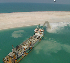
Dredging underway near Morro Bay, California, via flickr user mikebaird.

In other cases, industrially-constructed islands serve as the foundations for human settlements, whether accidentally (as in the case of Odaiba, originally constructed for military purposes), as fortuitous by-product of other construction activities (Manhattan’s Battery Park City, for instance), or through the intentional piling of seafloor sediment specifically extracted for island construction (as in the case of Dubai’s artificial islands).

[Update: Infranetlab’s first Glacier-Island-Storm post, “LandFab, or Manufacturing Terrain”, deals with “volcanic heroism, political anomaly, [and] development opportunism” as “catalysts of artificial, manufactured islands”, and explores several remarkable case studies.]

F. SEAMARKS, LANDMARKS, AND CIPHERS

Floyd Bennett Field, formerly New York’s first municipal airport — dedicated in 1931, passed to the Navy in 1941, and finally de-activated in 1971.

A note: I’m using “we” to refer to the project team, as I was a part of it, but I don’t want to create the (false) impression that I was responsible for the interesting parts of the project, as the conceptual work was done by Laurel and Terry.

A few years ago, I had the pleasure of working with landscape architect Laurel McSherry and architect Terry Surjan on an entry to a Van Alen Institute competition, “Envisioning Gateway”. The competition took as its site Gateway National Recreation Area, one of the nation’s oldest urban national parks, which is scattered around New York Harbor, split between New York and New Jersey, and meeting three boroughs. The core of each entry to the competition was to be a proposal for a new park at Floyd Bennett Field, a thirteen hundred acre former municipal airport situated in Jamaica Bay, on land largely composed of fill from the dredging of channels within Jamaica Bay and the surrounding waterbodies.

Shipping navigation channels within Gateway National Recreation Area, from the “Gateway Atlas” produced by Columbia GSAPP in support of the competition.

Our entry, entitled “Seamarks, Landmarks, and Ciphers”, was intended to serve as a “field guide” to the landscapes of Gateway, revealing hidden landscapes and making connections with distant landscapes:

Three types of connections – marks – are suggested to guide the revival of local and regional landscape knowledge: seamarks, landmarks, and ciphers. Located 1000 feet apart along cardinal directions, a field of sixty-two seamarks guide wanderers and inform observers of the locations and heights of future landform modifications. Varying in shape, size, and height, seamarks guide the creation of a midden – a near-continuous landform traveling the width of the site from the Gateway Marina to Mill Basin. Formed incrementally over a span of 11 years from local channel dredge, the midden serves as index (vertical) of the former Irish Channel bathymetry, datum both within and outside the site, and surrogate for the experience of an otherwise inaccessible landscape. The landmark field situates Gateway’s’ constructed landscape within the context of other national parks and monuments under the care of the Department of the Interior. The proposed series of stamp issues serves as cipher for the reading of Gateway’s local and regional landscapes.

A midden and a seamark.

The midden is perhaps the most relevant of these marks to a discussion of accretion and erosion. A midden is literally a “dung heap” or “refuse pile”, but it often refers to the piles of mollusk shells left by nomadic peoples or hunter-gathers along coastlines, often gaining such depth of accumulation that the middens appear nearly geologic in character, as in this photograph of a shell midden in Maine.

The proposed future topography of Floyd Bennett Field, showing the field of seamarks and section cuts through the dredge midden.

“Seamarks, Landmarks, and Ciphers” proposed to harness the deposition of fill from on-going local dredging by forming that fill into a midden tracing — at one-to-one scale and in-situ — the inverted bathymetry of the historical channels of Jamaica Bay, eventually producing a new artificial topography which would make tangible the enormity and scale of the industrial processes acting upon the bay. The midden would be constructed within a field of largely-shipwrecked seamarks, which would be marked with the heights of the coming depositions and so serve as forewarnings of the 2.5 million cubic yards of imminent industrial accretions.

G. MONSOON DESERT

Crescentic dunes — the most common kind of dune found “on Earth and on Mars”, formed “under winds that blow from one direction” — in the Thar Desert, just north of the Indus River Valley.

While the term “monsoon” is often associated with the strong seasonal rainstorms produced by winds such as the southeast trade winds of the Indian Ocean, monsoon refers literally to any “wind system with pronounced seasonal reversal”, and so the Thar desert in Pakistan and the Rajasthan desert in India, both of which border the Indus river, are properly termed “monsoon deserts”.   Though they drops the majority of their remaining moisture on the flanks of the Aravalli mountain range, the same monsoon winds which produce India’s famously wet summers sculpt the arid Thar and Rajasthan through eolian processes of deposition, producing a variety of crescentic, linear, and parabolic dunes.  Because of the stability of the monsoon system, the South Asian monsoon deserts are also relatively stable, having settled roughly into their contemporary configurations after the conclusion of the last global ice age — so monsoon deserts are, in other words, deserts shaped by the continued predictability of storm patterns.

H. DIMETHYL SULPHIDE

A 2005 article in the New Scientist notes that corals appear to, through a feedback mechanism triggered by symbiotic relationships with bacteria inside their tissues, release the chemical dimethyl sulphide into the waves above them.  As the chemical collects on the surface of the ocean, it is picked up by winds and “transformed into an aerosol of tiny particles on which water vapour can condense to form clouds”.  Corals, in other words, produce an excretion which forms seeds for the accretion of water particles: these islands form their own storms.

This biological climate-modification system serves primarily to self-regulate the temperature of the coral seas, producing more clouds to cool the corals as temperatures rise, and less as temperatures sink.  Unfortunately, a more recent study — also noted in the New Scientist, but only last week — indicates that  sea temperatures may be rising significantly enough to disrupt the production of dimethyl sulphide, which will dramatically reduce cloud formation over the Great Barrier Reef and, in turn, produce rainfall shortages in the north Queensland rain forests which depend on clouds formed over (and, it seems, by) the Great Barrier Reef.

I. AN AUGMENTED ECOLOGY OF WILDLIFE AND INDUSTRY

A traditional salt mine in the Galapagos, near Puerto Ayora; source for all images of Wen Ying Teh’s project.

One of the few industries to survive for any length of time in the Galapagos islands is salt mining, as naturally saline lagoons have been exploited by salt harvesters for centuries.  Unfortunately, one of the emblematic species of those islands, the Greater Flamingo, also depends on the same saline lagoons for habitat and food.  Because of the damaging effects of salt mining on the lagoons, Greater Flamingos are no longer found on Santa Cruz, the most populous of the Galapagos islands.

Wen Ying Teh‘s “An Augmented Ecology of Wildlife and Industry”, a RIBA President’s Medal winning project last year, proposes a hybrid structure — part building, part extension of the ecological process of a saline lagoon — which could be inserted into one of the salt mines near Puerto Ayora, supporting the salt mining industry while restoring the ecological balance of the saline lagoon, drawing Greater Flamingos back to Santa Cruz.

The structure, which hosts a brine shrimp hatchery, salt crystal harvestry, salt market, tourist education center, and flamingo observatory, protrudes linearly into the lagoon before fanning out into a series of tanks housing the brine shrimp.  The skin of the structure is composed of hanging nylon threads, which wick salt from the lake through capillary action, crystallizing a mineral skin that is cyclically harvested by the salt miners, so that the building pulses through the seasons with the wax and wane of sodium chloride.  Because the miners no longer need to disturb the lagoon to harvest salt, the natural balance of the lagoon can be restored.

Wen Ying Teh conducted physical experiments at scale to test the proposed nylon fiber system and the capillary deposition of salt upon the system.

The cyclical growth of the salt skin, shown over the shrimp tanks.

In Wen Ying Teh’s project, the building itself is constituted by processes of accretion and erosion: salt accretes to form the skin through capillary action, and then is eroded, both by harvesting and by rain, with the latter process of erosion being tied into the maintenance of proper salinity for the shrimp hatchery.  The structure serves as an extension of the lacustrian ecosystem, not just physically, but in time and process.  While in some ways this is an amplification of processes that already occur on buildings — eroding as they weather, accreting objects, paints, memories, and so on as they’re occupied and augmented and built upon — making accretion and erosion not just ancillary to the architecture, but central to it, remains an unusual and beautiful approach.

I first saw Ying’s project at dpr-barcelona; Ying’s tutors were Kate Davies and Liam Young, of the always-interesting Tomorrow’s Thoughts Today.

readings: cars, ships, and nuclear reactors


[all photographs from Andrea Frank’s series “Ports and Ships”]

1. Dave Roberts reviews two books on the future of automotive transportation — Traffic and Reinventing the Automobile — in the American Prospect, primarily discussing “USVs”, the descendant of MIT’s CityCar.  Roberts’ review explains why mammoth is so excited about CityCar as an architectural tool:

Where the vision tips over from cool-for-car-nerds into mind-blowing is not in the car itself but in how it’s connected to the power grid, other cars, and the city around it. Most cars are parked about 95 percent of the time. All those idle batteries add up to considerable energy-storage capacity. Having a place to store electricity is important because America’s power system, like its cars and parking infrastructure, is overbuilt, scaled to meet peak demand. With a place to store surplus electricity when it’s made and release it when it’s needed, system engineers can “shave the peak.”

The authors envision USVs converging with other technologies — rooftop solar panels, small wind turbines, geothermal heat pumps, cogeneration systems, large-scale batteries, smart grids — to create a new kind of power system in which cities are generating, managing, and distributing all or most of their own electricity. This kind of local, distributed power system will eliminate the high cost of transmission lines bringing power from a distance, reduce smog and other particulate pollution, eliminate dependence on foreign energy, and, at the limit, make possible carbon-neutral cities…

[A] “Mobility Internet” could lead to the same kind of innovation unleashed by the Internet itself. Among other things, it could enable a revolution in civic management of road, parking, and power services. Currently the large majority of roads and a great deal of parking is free, and as any economist will tell you, an unpriced resource will be overused. Sure enough, road and parking demand frequently exceed supply, leading to congestion, a good chunk of which, Traffic reminds us, is created by people driving around looking for parking (“parking foreplay” also causes one in five urban collisions). Although power isn’t free, it’s generally sold at a flat rate, leaving consumers no way of knowing when it’s most valuable.

Toll roads and congestion charges are crude attempts to change the situation. Once the devices that consume road, parking, and power services are connected to the Internet, however, cities can institute variable, real-time, citywide pricing for those resources, based on the balance of supply and demand moment to moment. This could radically increase the productivity of resource use, compensating at least in part for the expense of building these systems. Cities would become more like organisms, their subsystems controlled and coordinated by a unified nervous system. (Water and sewage systems could be integrated to the digital grid as well and even used as backup energy storage — but that’s another story.)

Ryan Avent picks up on the Roberts article, discussing regulatory barriers to innovation in automotive transport and then clarifying his thoughts in a second post.


[Modelling global shipping routes, from Pablo Kaluza et al.’s “The complex network of global cargo ship movements”, via Infectious Greed]

2. Meanwhile, cities on the West Coast prepare infrastructure for the impending arrival of mass-produced electric cars.

3. Back on the East Coast, the Obama administration approves financial aid for the construction of the first two new nuclear reactors in the United States since the seventies.  mammoth applauds, and hopes that we can look forward to visiting an American La Hague in a decade or two.

4. The Danish shipping giant Maersk is pioneering the development of “super slow shipping”, or the intentional operation of container ships at lower speeds to realize greater energy efficiency, decreasing both fuel consumption (which is profitable) and carbon emissions.

5. Chicago and the Army Corps of Engineers ponder undoing the reversal of the Chicago River, in a “last-ditch effort to prevent the Asian carp from decimating the $7 billion Great Lakes fishing industry”; the de-reversal is heavily opposed by the Great Lakes shipping industry, and would require re-thinking Chicago’s constructed urban hydrology, as flood control measures depend on the current configuration to deal with peak flooding.

[link 2 via @bldgblog, link 5 via Delta National Park]

paul kersey, yimbyist

Dan Hill has (another) excellent post at City of Sound examining what he’s referring to as “emergent urbanism”, or the “knitting together [of] the everyday loose ends in urban fabric” by community organizations and individuals acting “outside of traditional planning processes”.  I’m particularly pleased by (a) the presentation of the example of Renew Newcastle, which, not being Australian, I wasn’t at all familiar with, (b) Dan’s emphasis on “YIMBYism” (the term is taken from a group in Stockholm), or enabling positive citizen participation in the planning process (as an alternative to stereotypical NIMBYism, in which the community has no involvement in the urban planning process until it object vociferously and often destructively — though frequently with good cause — to a proposal which is nearing construction), and (c) the attempt to reconcile the existence of central-planning processes with the potential of emergent urbanisms, which strikes me as quite realistic, given that both will continue to act upon cities in varying measures, regardless of urbanists’ ideological predispositions towards one or the other.

Both (b) and (c) may shed some light on another excellent recent article, “Lethal T-Square” published at Places, which, taken together with a similar Plantizen article from 2008, offers a reading of Charles Bronson’s vigilante-architect from the film “Death Wish” as either crusading proto-NIMBYist par excellence Jane Jacobs or Jacobs’ most famous antagonist and symbolic figurehead for modernist urbanism’s self-destructive relationship with central planning, Robert Moses.  Keith Eggener, author of “Lethal T-Square”, and Nate Berg, author of the earlier Plantizen article, offer up Bronson as either Jacobs (because Bronson is willing to fight for his community) or Moses (because Bronson is willing to break some things in order to fix others), but perhaps it is most useful to realize that, just as Hill suggests that urbanists should continue to pursue both better central planning and better emergent process, both readings may be accurate at once, though there are elements to be both lauded and to be condemned in the fruits of both Jacobs’ and Moses’ labors.

While moderation, whether in reading a film or planning a city, can at times be bland, it can also be realized through the vibrant pairing of extremes: not just vigorous centrally-planned transit infrastructures or motivated communal self-re-organization (or a muddled combination of neither, which might be the most accurate characterization of contemporary American urbanism), but both in tandem.

double happiness

Bureau de Mesarchitecture’s “Double Happiness”, an installation for the 2009 Shenzhen-Hong Kong Bi-City Biennial, is described by the architects as a piece of “nomad” “urban furniture”, allowing users (who presumably own a forklift) to “reanimate” and “reappropriate” the public spaces of their cities, which, despite the obvious deficiences seems to me an appropriately ambitious aim for the design of street furniture.  Who wouldn’t care to occasionally swing suspended a story above Broadway (a series of these marching past Times Square might serve very well to liven up the now-permanent pedestrian plaza), or to sway gently while watching crowds meander past the White House?  Even those unable or unwilling to climb the platforms could share vicariously; I’m reminded of the small crowds which often formed in the parking lot on the site of the former Washington Convention Center this past summer and fall to watch the trapeze school which had set up shop in one asphalt corner.

But, as Stephen suggested to me earlier today, it’d be rather more interesting if it wasn’t merely an innovative piece of furniture, but an architectural device for hacking billboards, as the post and frame’s form gently suggests — a modular package of guerilla playground equipment.  Bands of roving swingers might snap them onto billboards under the cover of nighttime darkness, then sway child-like in and out of the harsh glare of the bulbs spotlighting advertisements, before melting back into the city with their illegal swings, waiting for the next spontaneous reconfiguration; the posts, railings, poles and signs of the city the armature of their playground.

[image and link via Archiact; update: see Yes Duffy’s Urban Swings project, via Luke Perry in the comments]

the dead sea works

I was reminded of the Conveyor Belt for the Dead Sea Works (pictured above) by FASLANYC‘s post last week, which rightly notes that Israeli landscape architect Shlomo Aronson completed a small series of projects in the mid-eighties which prefigured the contemporary interest in landscape infrastructures. While the conveyor belt is an obviously sculptural (and beautiful) presence in the Rift Valley landscape, a more important concern for the invisible patterns of the Judean desert ecology drives the architecture of this infrastructure and makes the project significant as a case studio in the ability of an architect to enhance the ecological function of a large-scale infrastructure.

The origin of the conveyor belt, at the potash extraction site; the belt is highlighted with a faint red line.  The belt is easily picked out against the desert topography in satellite imagery.

The conveyor belt, at 18 kilometers the third longest in the world (at least at the time of its design), was planned by the Dead Sea Works to convey over a million tons of potash each year from the extraction site (400 meters above sea level) to the Dead Sea Works’ main factory on the banks of the Dead Sea (400 meters below sea level).  The belt replaced a “tortuous 39-kilometer truck route where 200 semi-trailers a day loaded with potash once clogged traffic, created a safety hazard, damaged the road, and spewed diesel fumes”.  Israel’s Nature Reserves Authority at first opposed the project (which would span the entire South Judean Desert Nature Reserve, “known for the flora, wildlife, and archaeological sites of its unspoiled canyons and cliffs”), citing the fragility of the desert environment, but later approved it on the condition that the Dead Sea Works employed a landscape architect to design the conveyor belt.

Aronson redrew the planned belt route to avoid building unnecessary earthworks, while lengthening bridges to allow “free passage for hikers and desert animals”.  Bridges, which also replaced earthworks wherever possible, were constructed by cranes perched either on the route of the belt or on previously built sections of the bridge, so as to minimize the impact of construction on the delicate desert ecology.  Aronson required all work to be done within a narrow 10-meter construction corridor; this restriction was followed strictly, despite the need to move over a million tons of earth and to construct 12 bridges.  The delicate steel bridges and the yellow ochre sheath of the conveyor were selected to simultaneously emphasize the lengthy infrastructure as a significant engineering feat while permitting the belt to complement, rather than overwhelm, the existing landscape.

The conveyor terminates in the Dead Sea Works’ industrial complex on the southern end of the Dead Sea.

The conveyor belt, then, at both the local scale (bridges, earthworks, pylons) and the regional scale (the route) was constructed specifically to account for both visible aims (the preservation of the scenic value of the Syrian-African Rift Valley) and invisible aims (the free flow of wildlife, the avoidance of damage to local ecologies).  It serves at once as a statement of the scale of human intervention in the Israeli landscape and as a statement of the possibility of designing that intervention so as not to detract from that environmentt, but to augment and emphasize the intrinsic beauty of the pre-existing landscape.

The Dead Sea Works at dusk, framing the Salt Ponds; photograph via Israel Tour Guide.

As fascinating and long as the belt is, though, it is a relatively minor infrastructure in comparison to the vast — eighteen miles long — Salt Ponds it feeds its cargo onto the shores of.  And those Ponds perhaps present an opportunity for a much more substantial landscape intervention, one which would not merely seek to ameliorate the conditions produced by accepted industrial processes (as Aronson’s conveyor belt does so skillfully), but would look to fundamentally reorganize those processes.  This difference of opportunity may serve to effectively highlight the difference between two possible answers to the question FASLANYC poses, “what value do landscape/architects add to the design of infrastructures?”, a question which mammoth has previously been concerned with.

The Dead Sea Works are a major global chemical producer, supplying in particular potassium — one of the three primary ingredients in chemical fertilizers — to over sixty countries on five continents.  An article (part of a larger series entitled “Life from the Dead Sea”, which is worth reading if you’re intrigued by the Dead Sea) at WysInfo describes the production process:

The potassium in the Dead Sea is… produced at the Dead Sea Works by a process based on selective sedimentation of the non-required minerals in a system of evaporation ponds until the solutions of the desired composition are finally obtained.

For the construction of the ponds a system of dams was built which today encompasses the Israeli sector of the shallow southern basin of the sea, which is now in fact a vast evaporation pond.

At present, the water of the Dead Sea is pumped from the deep northern basin a distance of 400 meters and carried in a canal to the southern basin, into the ponds, where – through natural evaporation – the water loses 50% of its initial volume and kitchen salt and calcium chloride crystallize out into a second system of ponds. Here the carnallite, which is the raw material for producing potash, crystallizes and sediments. Potash is an impure form of potassium carbonate (K2CO3) mixed with other potassium salts. Potash has been used since ancient times as a fertilizer and in the manufacture of glass and soap.

This material is mechanically “harvested” from the bottom of the pools and pumped through pipes to the potash plant. Here the carnallite crystals are separated from the stock solution and washed in water to dissolve the magnesium chloride in the solution…

In order to add value to the relatively cheap raw materials (also including bromine, magnesium, and salt) harvested from the Dead Sea waters in the evaporation ponds, the Dead Sea Works refines the harvested potash into compound fertilizers, a process which multiplies the value of the chemicals ten-fold, but requires combining the Dead Sea potassium with “phosphate-rich sediments [found] to the west of the Dead Sea”, which are brought to the shores of the Salt Ponds on Aronson’s conveyor belt.

Evaporation ponds in the southern basin of the Dead Sea; image source.

This chemical harvest produces a great deal of economic benefit for Israel, providing employment to thousands and being the primary way in which Israel benefits from the mineral wealth of the Dead Sea (which is the largest concentration of accessible mineral within the country’s borders — estimated at 1.9 billion tons of potassium chloride and as much as 44 billion tons of salt), but the continuous diversion of mineral-laden water from the northern basin of the Dead Sea south into the evaporation ponds is exacerbating the already perilous shrinkage of the Sea.

The Dead Sea Works in 1944; image source; the history of the Dead Sea Works begins around 1920, when a Russian engineer by the name of Novomeysky realizes that the Dead Sea’s mineral wealth might be tapped cheaply through solar evaporation.  By the Second World War, the Dead Sea Works (then known as the Palestine Potash Company) produced approximately half of all the potash used in British agriculture.

An article in Smithsonian magazine from 2005 explains the history of the Dead Sea and how it came to enter its current state of rapid decline:

Created by the same shift of tectonic plates that formed the Syrian-African Rift Valley several million years ago, the Dead Sea owes its precarious state to both human and geological factors. Originally part of an ancient, much larger lake that extended to the Sea of Galilee, its outlet to the sea evaporated some 18,000 years ago, leaving a salty residue in a desert basin at the lowest point on earth—1,300 feet below sea level. Since then, this body of water, known as the Dead Sea since Greco-Roman times, has maintained its equilibrium through a fragile natural cycle: it gets fresh water from rivers and streams from the mountains that surround it and loses it by evaporation. The evaporation process, combined with its rich salt deposits, account for its extraordinary—up to 33 percent—salinity (compared with the up to 27 percent salinity of Utah’s Great Salt Lake). Until the 1950s, the flow of fresh water equaled the rate of evaporation, and Dead Sea water levels held steady. Then in the 1960s, Israel built an enormous pumping station on the banks of the Sea of Galilee, diverting water from the upper Jordan, the Dead Sea’s prime source, into a pipeline system that supplies water throughout the country. To make matters worse, in the 1970s Jordan and Syria began diverting the Yarmouk, the lower Jordan River’s main tributary.

Since then, the Dead Sea has declined dramatically. It needs an infusion of 160 billion gallons of water annually to maintain its current size; it gets barely 10 percent of that. Some 50 miles long in 1950, the sea is about 30 miles long today. Water levels are falling at an average rate of three feet per year. According to a recent Israeli government study, the rate of evaporation will slow and the Dead Sea will reach equilibrium again in a few decades—but not before losing another third of its present volume.

Ironically, though the northern basin is imperiled by retreating water levels, posh hotels along the industrialized southern basin of the Dead Sea are besieged by rising water levels produced by the deposition of waste salts, which lifts the bed of the southern basin approximately seven inches a year, causing the hotels to surround themselves with sand dikes and plan for a leisure lagoon, cordoned off from the industrial ponds.  At the northern end, hotels obviously have the opposite problem: the beach is racing away from their doors, so hotels employ tractors and wagons to ferry tourists from their rooms to the banks of the Sea.  The declining overall volume of the Sea is also emptying the surrounding freshwater aquifers, producing over a thousand gaping sinkholes in the past fifteen years, as retreating freshwater dissolves underground salt deposits.  Together with increased erosion, the sinkholes have destroyed roads, date palm orchards, and buildings, producing a landscape sufficiently unstable to lead the Israeli government to proclaim a development freeze in the vicinity of the Sea.  Complex oasis ecosystems which belie the Sea’s moniker by supporting vibrant communities of flora and fauna, including five hundred million migratory birds who stop at the Dead Sea between Africa and Europe, are similarly threatened.

This environmental and economic catastrophe is by no means solely the result of the industrial processes employed at the Dead Sea Works, but the evaporation ponds do contribute significantly to the draining of the northern basin (by one estimate, approximately a quarter of the yearly shrinkage is attributable to the Dead Sea Works).

The Jordan River, historically the primary source of replenishment for the Dead Sea, spreads its watershed through the territory of Israel, Palestine, Jordan, Syria, Lebanon, and Egypt, producing an exceedingly difficult intersection of hydrological and political territory, making the implementation of watershed-level policy nearly impossible; map via the United Nations Environmental Programme.

In a watershed as water-poor as that of the Jordan River, increased conservation alone will not be able to reduce freshwater demands to levels which could reverse the shrinking of the Dead Sea, though there is no doubt that increased conversation is necessary.

Given that reality, a number of serious large-scale engineering proposals to reverse the drainage of the Dead Sea exist, including two plans for massive canals linking the Dead Sea to larger waterbodies which could replenish it — the Red Sea to the south and the Mediterranean to the west, as well as the development of mass-scale desalination plants which could supply fresh water to replace that taken from the Jordan and its tributaries, potentially affording the opportunity to let the Jordan run freely into the Dead Sea again.

“The Dead Sea #6”, via flickr user justavessel

But perhaps what is needed is not merely a new set of mega-infrastructures, diverting water across deserts from other watersheds (and doing so in a manner which is potentially quite dangerous), but a re-configuration of the industrial processes at work in the Dead Sea, a re-shaping of the industrial landscape to create positive feedbacks into biological systems?  One might easily believe that the Dead Sea is exactly the sort of industrialized and urbanized “bio-physical system” which Pierre Belanger has argued (PDF) can only be understood and dealt with at a watershed-scale:

Endogenous and exogenous processes, such as eutrophication, combined-sewer overflow, sediment contamination, invasive flora, exotic fauna, depleted water reserves, and seasonal floods can no longer be perceived as isolated incidents but rather as a part of a large, constructed hydrological ecology that is entirely and irreversibly connected to the process of urbanization…

What form a landscape infrastructure for the revitalization of the Dead Sea might take is difficult to say; perhaps the Dead Sea Works might be inspired by their success at producing salt from salt water, and try their hand at separating out the other component in that raw ingredient, augmenting the salt ponds and fertilizer-production facilities on the southern basin with networks of desalinization plants, capitalizing (as the ponds do, through evaporation) on the plentiful solar energy of the Negev to power those plants.  Or perhaps, like Orange County, a far-sighted municipality could construct a string of wastewater recycling plants and recharge the freshwater aquifers surrounding the Sea, halting the spread of erosion and sinkholes.  Whatever the form, agriculture, industry, wastewater systems, and natural ecologies could be viewed not as competing interests vying over a singular and shrinking water supply, but as necessary components of a single regional urban ecology, with waste flows from one component providing the raw material for the processes of others.

Quotations in this post related to the conveyor belt are derived from both an article, “Desert Conveyance”, which ran in Landscape Architecture in April 1991 and Aronson’s monograph, Making Peace with the Land.  I’m afraid that I didn’t record which quotations came from which source when I originally took them down several years ago; related to the larger question of the Dead Sea Works, doubts linger about the long-term sustainability of any regional economy based on phosphorous production or application: read Infranet Lab on “peak phosphorous” and further background on “peak phosphorous” in this article by Melinda Burns (via @bldgblog), which includes the suggestion by a scientist that “there’s a whole industry that needs to be invented to capture phosphorus” — perhaps a further clue to what a re-invented Dead Sea Works might look like, as the phosphate waste products of farming, as well as the urban sewage choking the Jordan, could become the raw material for industry and the water wasted by industry the lifeblood of agriculture and a reinvigorated Dead Sea.

but do they know how you take your coffee?

Charles Petersen, in the New York Review of Books, on the rise of facebook.

If anything, Zuckerberg looks, in some distant but discernible way, like the Robert Moses of the Internet, bringing severe order to a chaotic milieu. While several efforts have been made to create more open versions of social networks, none has found much success. We are still waiting for the Jane Jacobs of online “urban planning” to appear…

Urban-analogy bonus-points aside, what I found interesting about this article was the comparison between the types of targeted advertising Google is capable of, and what Facebook is [expected to be] capable of.

Because of its unparalleled demographic information, Facebook can sell ads that will appeal only to carpenters in one small town in Vermont, or to graduates of the Harvard Business School, or to residents of Manhattan who list “opera” as an interest. The site could also provide the most highly targeted political ads in history. Google can sell ads that will appear in a particular locality, as Scott Brown showed by buying up much of the online ad space for Massachusetts during the final days of his successful bid for the Senate. With Facebook Connect, it may be possible to show ads specifically targeted to Massachusetts residents who use words such as “Irish,” “Italian,” or “black” in their profiles, or who list their religion as Catholic, Protestant, or Jewish. So far, however, advertising has only provided enough revenue for the site to barely break even, and many believe the site can only claim to be profitable because of creative accounting.

But is Facebook’s demographic information ‘unparalleled’, as Petersen claims? I think this forgets the massive amounts of data on personal preference collected by Google each time we make a search (or use Google maps, or add a website to our Google reader account, or compose an essay on Google docs, or send an email, or…). And in a way, I would think this information is far more valuable to advertisers than the personal information on Facebook. The latter is data that 1) we choose to share and 2) isn’t necessarily about us, so much as it is about the personality we choose to craft online. The data Google has is much more personal – it concerns the actions we want to take, the places we want to go, the knowledge we want to have. The Google might know us better than we know ourselves.

[link via James Fallows]

mine the gap

Via Pruned and elsewhere, the Chicago Architectural Club has just launched a spring competition, “Mine the Gap”, which holds a great deal of promise:

…at a moment when the global recession has either slowed or frozen completely the driving forces that had propelled architecture and urbanism over the past decades. The bursting of the realestate bubble has left many architects without work, and a number of building sites within the city sit incomplete or abandoned. Yet there is opportunity in this collapse. Despite the apparent desperation of the moment, we detect a newfound freedom for architects to speculate, to propose, to instigate and to agitate for a different city. This competition aims to exploit that new freedom and to define the role of the architect in an economy of crisis and a city full of scars.

The competition site is the abandoned footprint for Calatrava’s proposed Chicago Spire, and, as a metaphor for the state of contemporary architecture and urbanism, is nearly perfect, the seventy-foot deep shaft presenting unmistakable psychogeographic and geologically-scaled evidence of the ruin produced by our financial system’s institutional arrogance.  Entries are due May 3rd.

vancouver whitesward

[Thin veins of augmented and imported snowpack wind down Cypress Mountain, prepared for the Winter Olympics in Vancouver (“snow was being trucked to Cypress Mountain from higher elevations” and “organizers had placed tubes filled with dry ice on courses to keep surrounding snow from breaking down”), via NASA Earth Observatory.  Read more about whitesward at Places, mammoth, BLDGBLOG, mammoth, BLDGBLOG and Infranet Lab; a New York Times article, via Pruned‘s Alexander Trevi, describes the scene at Cypress Mountain: “the mountain looked as if it were under military siege, not an Olympic site days from competition”.]

metropolis prognostications


[Storm surge barriers under construction near New Orleans; image source]

In their January issue, Metropolis asks architects and designers to offer predictions, inspirations, and prognostications for the coming decade.   It’ll be no great surprise to readers of mammoth that I’m particularly intrigued by the predictions grouped under “landscape architecture”, which involve reconstructed storm barriers in Louisiana, an “embedded infrastructure for carbon storage within the existing physical and social land uses of the city”, and ‘soft coastal engineering’, but there are numerous other fascinating prognostications, including self-healing concrete; bridges which, via “fiber-optic nervous systems”, monitor their own stress levels and temperature differentials to predict failure; mining landfills for “their valuable metals and minerals”; nursebots (“a GPS system with memory in a walker”); the replacement of garbage trucks and garbage cans with garbage shoots and tubes — an “Envac system for waste management”; and “the evolution of the big box into urban spaces” (or, Wal-Mart in a Manhattan basement).