mammoth // building nothing out of something

border box

The following piece is a part of Border Town’s supplementary online discussion, which is collated at the Border Town website.  Border Town is a “10-week, multi-participant collaborative design studio that investigated the conditions that surround life in cities situated on borders, divided by borders, or located in conflict zones” this summer, led by Tim Maly and Emily Horne. Border Town is currently exhibiting at the Detroit Design Festival; the exhibition runs through September 26.


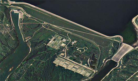
[Top, the Hampton Roads region, home to the Port of Virginia, and above, the Norfolk International Terminal.]

When a cargo container is offloaded at one of the marine terminals of the Port of Virginia, a funny thing often happens.

Let’s say that the container — which might, for instance, have been loaded in Hong Kong, transited the Pacific Ocean, and crossed the American continents at the Panama Canal — is picked off a container ship by a container gantry crane at the Norfolk International Terminal, one of the four terminals within the Port of Virginia’s distributed network of terminals around the Hampton Roads region.  There is a good chance that it will then be loaded onto a double-stack railcar by a straddle carrier or rubber-tyred gantry crane, and travel around two hundred miles on the tracks of the Norfolk-Southern Railway to the small city (calling it a city is rather generous) of Front Royal, where it will be offloaded at the Virginia Inland Port. Here’s the funny thing — only then do its contents finally enter the United States of America.


[The Virginia Inland Port in Front Royal, Virginia.]

When the shipping container is (rightly) treated as a transformative technology, it is usually the physical properties of the container that are cited as generating transformations: the standardized measurement of the twenty-foot equivalent unit both permitting and demanding the standardization of port spaces, container ships, and distributive mechanisms like tractor-trailers and railcars, for instance. But the legal properties of the container (which, it should be noted, are only possible because of the physical capacity of the container to be sealed in such a manner that opening it permanently breaks the seal) are also transformative, and it is these weird legal properties that produce the funny situation of goods being two hundred miles inside a nation’s borders and yet still, for all intents and purposes, in a foreign country.

In the rather dry manner typical of government bureaucracies, the U.S. Customs and Border Protections explain this in one of their key publications, “Importing into the United States: A Guide for Commercial Importers” (pdf):

“Imported goods are not legally entered until after the shipment has arrived within the port of entry, delivery of the merchandise has been authorized by CBP, and estimated duties have been paid.”

The shipping container, you see, is something of a minature, portable, re-definable border. When it is sealed, goods are frozen in their country of origin, and cannot be removed from that country through any physical operation short of breaking the seal and stealing them. In this way, the shipping container is like a bizarre embassy: portable instead of stationary, for goods instead of people, logistical instead of architectural, but similarly self-contained and exported territory. Both the shipping container and the embassy reveal that borders are, at the same time, fictional — receiving their status as entities that exist through the agreement to treat them as though they exist, and thus being as malleable as we collectively decide we want them to be — and quite capable of affecting material relations, as noting that they are fictional by no means implies that they lack the capacity to draw geographies or generate landscapes.


[Port of Hong Kong; source.]

1 In the United States, a foreign trade zone is a legally-designated geographic area “considered to be outside of U.S. Customs Territory for the purpose of customs duty payment” — a place where goods can be imported and exported without needing to pass through customs. Manufacturers locate in foreign trade zones in order to free their global supply chains from the constraints of state borders. (Globally, similar areas are often designated “free trade zones” or “special economic zones”.)

Having been granted this status, the container becomes legally frictionless, able to transcend borders and geographies freely, at least until it arrives at a customs station. To move through a country, a container never needs to enter that country; it can exist solely within the legal weightlessness of foreign trade zones1, even serving as a microcosm of those legal states when it exits their spatial boundaries (such as when it travels from a seaport to an inland port of entry). The goods in a container loaded and sealed in Hong Kong remain legally in China, no matter what soil the container rests on, until such a time as the owner decides to have them processed at a customs station.

Yes, this is a restricted geography. A container cannot arrive at a seaport, bypass customs, and travel freely within the country of destination; but within that restricted geography — along rail-lines and in anonymous stacks — the container is oddly weightless. No person could arrive at the border of the United States, declare himself a microcosm of China, and travel freely to the airport customs line of her choosing; the comparative freedom granted to the movement of goods seems appropriately representative of the relative primacy of consumer goods in the post-Fordist economy. Perversely, the container is even co-opted by people desperate to emigrate from or immigrate to certain nation-states — essentially, people attempt to pass as goods, in order to obtain the legal advantages conveyed on goods.


[A gantry crane operates at an intermodal facility in North Baltimore, Ohio; source.]

The connection may not be immediately obvious but this — all of this, including the transformative physical properties of the container briefly noted above — is why the architectural fetish for the form of the container is ultimately unsatisfying. Even though the spatial qualities of the box are transformative, the form of the container is ultimately not what it is interesting about the container; what is interesting and important about the container is the way that it enables and generates new landscapes. This is not to say that is impossible to do interesting architecture with shipping containers. It is just as possible to do interesting architecture with shipping containers as it is possible to do interesting architecture with chain-link fence, corrugated aluminum, or any other industrial material. But the power of the shipping container cannot be appropriated by using the object in alternate contexts, because the power of the object comes from its capacity to shape its context.

Keller Easterling said this well in a 1999 piece for Perspecta, “The New Orgman”; though the portion of the piece that we quote here refers to the architecture of mid-century suburbia, the piece later touches on ports and containers, and the quote applies equally well to the container:

“The architecture [is] organizational. The organizational protocol [is] not merely that which facilitate[s] architecture; it [is] architecture… For architects, nouns and objects that can be identified with formal nomenclature are more familiar than processes, verbs, and games. It is hard to grasp the idea that the medium is the message or that the organization is the content.”

Hard, but worthwhile.

behind the scenes

While there is a lot that has gone unfortunately unposted this summer (our drafts queue is more than a little bit out of control) — at least in part due to Rob’s failure to contain the floods series (which is finished, by the way, with yesterday’s final post on de-damming the Dutch delta) to anything like a reasonable length — there are a number of exciting things going on at mammoth behind the scenes.

Some of them will hopefully make appearances here in the coming months; some of them may also manifest, but in other ways; and some of them are likely to take quite a while to mature to the point that they have a public manifestation, but those might be the ones we’re most excited about.  (Very vague, we know.)

Two particular academic matters seem worth noting at the moment.  First, Stephen is in the midst of evaluating real estate development graduate programs, and is consequently anticipating a possible return to school in the near-or-mid future.  Second, Rob is teaching studio for the first time this fall in Virginia Tech’s MLA program, at the Washington-Alexandria Architecture Center.

It’s unclear what this will mean for the blogging in the fall; perhaps these things will leave us energized and imaginations fertilized; perhaps they will drain us, and blogging will be light.  That will be what it is, either way.  There is a medium-sized backlog of things we wrote over the summer (while the blog was occupied with the flood series), and we expect to publish those over the coming month.  This should include text from our talk at Infranetlab’s Pamphlet Architecture launch at Storefront, a long update to the Preliminary Atlas of Gizmo Landscapes that Rob presented at MediaLab Prado, another student project or two, some excellent guest posts, and, apropos of that last item, a week about shit. Literally.

Finally, some of our good friends have been working on Border Town, “an independent design studio about divided cities”. They are in the midst of an exhibit we are sorry to be missing in Detroit, but we’ll have a contribution up shortly to the online discussion they’ve been fostering.

de-damming the dutch delta


[The Haringvliet Dam]

In recent years, as they seek to rethink the flood control infrastructures and climate defense systems of the Mississippi Delta, American politicians, engineers, planners, and designers have, with good reason, looked to the Netherlands for inspiration and expertise.

This is entirely natural, as the Netherlands has long been the world’s most sophisticated laboratory for deltaic infrastructural experimentation.  In this vein, a recent studio at Harvard GSD, run by Nina-Marie Lister and Pierre Belanger, looked at potential futures for the region around the city of Dordrecht in the Rhine-Meuse Delta.

One of the projects that emerged from this studio, Kimberly Garza and Sarah Thomas’s “de-Damming the Dutch Delta”, makes a proposal that has a great deal of relevance for discussion of the future of the Mississippi Delta: open the massive (3-mile-long) Haringvliet Dam, permit salt and fresh water to mix freely again in the Haringvliet estuary, and make the resultant emerging aquatic ecology the central organizing infrastructure of an alternate urbanism.

There are a couple of things that make this project particularly compelling.

The first is the central role that Garza and Thomas give to re-thinking a key datum.  Landscape architects have paid increasing attention in recent years to the ways that both standardized measurements and standardized measuring tools serve to not only measure landscapes, but also to shape them.  (Gunter’s Chain and the Jeffersonian Federal Land Ordinance of 1785 being two connected examples that have received a fair bit of attention.)  Garza and Thomas identify one such generative measurement, the Normaal Amsterdam Peil, or NAP.  The NAP dates to 1675, when it was established Mayor Johannes Hudde to denote the average summer high flood elevation of the sea adjacent to Amsterdam.  The use of the NAP spread widely through Europe, and is used to establish littoral policies, laws, and regulations.  (The coastline drawn for the Netherlands on a normal map, for instance, is the coastline as set by the boundary between water and land at NAP.) The functional effect of the NAP, then, is to reify a “binary relationship”, as Garza and Thomas say, “between land and water”: on this side of the line drawn using the NAP, you have water; on the other side, you have land. This at once expresses and reinforces an attitude about the way that humans use and occupy littoral terrain, which privileges certain programs — such as the construction of dams that neatly separate salt and fresh waters — while excluding the possibility of other programs — such as an economy based on the biological productivity of the fluctuating gradient that typically occurs when salt and fresh waters mix.


[Registering fluctuating deltaic conditions]

To re-open the possibilities that a more complex understanding of the relationship between land and water would permit, Garza and Thomas propose the replacement of the NAP with a dynamic Normaal Amsterdam Peil, or d(NAP), which would measure water level not as a single datum, but a gradient of possibilities, ranging from a summer low to a winter high and beyond to the highs produced by flood conditions. The incorporation of true flood conditions into the conception of normal is exceptionally important, as it produces an understanding under which flood conditions are not unexpected disasters, but anticipated and recurring conditions of the landscape — normal.

1 This capacity to generate massive change through comparatively small intervention is what we at mammoth have described as thegenerative capacity of infrastructures.  Our friend Brian Davis, though, reminds us that it is not just a capacity of infrastructures; it is a fundamental capacity of landscape, essential to the landscape-ness of landscape. Put more simply, when you work with landscape, you get more out of it than you put into it. (And what you get will often surprise you — landscape transforms, alters, and weirds, which is why it always entropically resists attempts to polish and control it.)

This overlap between the capacity of landscape and the capacity of infrastructure is quite intriguing conceptually; it serves to explain why, for instance, an increased interest in infrastructures emerged within and fed the growth of the nascent discipline of landscape urbanism, as well as why the work of architects within that discipline tends to feel so much like landscape architecture.

Having developed the conceptual grounds for their project, Garza and Thomas make two deceptively simple moves, which they suggest could have the effect of generating new economies, new patterns of land use, and ultimately new urbanization within the Dordrecht region1.  The first, as mentioned above, is to open the Haringvliet Dam, permitting fresh water and salt water to mix again within the Haringvliet estuary, as well as restoring silt-depositing tidal dynamics.

The second move is the provision of “bivalve infrastructures”, constructed armatures (above) which accelerate the development of bivalve reefs on new subaqueous ground produced by restored silt deposition.  Garza and Thomas explain why they are so keen on the restoration of that process of silt deposition and the development of bivalve ecologies:

…the ground is transformed with the accretion of the estuary’s most vital resource: mud. Together with tidal dynamics, silt and sedimentation of the mudlfats enable reefs to build up and accumulate, hosting the colonization of thousands of bivalve species, one of the basic building blocks of intertidal ecologies. The benthic and pelagic foodshed begin to thrive: plankton and bacteria, clams and crabs, smelt and salmon, beavers and seals, reeds and cattails, willows and poplars.

…bivalves have the ability to generate new economies… during the Middle Ages the Dutch economy once thrived on the delta. The establishment of bivalve reefs would enable the habitations of a larger bio-system, including salmon, flounder, oysters and mussels.

If we focus on the economic importance of the oyster, full economic value goes beyond dockside value. In addition to primary sales of raw, unshucked products, there are economic benefits from secondary services such as: shucking and packing houses, transport and manufacturing of prepared oyster products and retail sales. The shell itself is used in several different products, from ‘oyster shell calcium’ to ‘oyster shell concrete.’ More interestingly, the city of Dordrecht can utilize the oyster and the intertidal zone to generate a pearling industry. Mudflats will generate bivalve economies altering urbanization patterns inside and outside the dike and ultimately will position Dordrecht as a global player.

2 Or, “opportunities for a flood-based economy”, as Laci Videmsky (who was also in this same GSD studionoted on twitter — with specific reference to Bangkok, but easily applicable to both Louisiana and the Haringvilet.

This vision of urbanization re-organized around the productive capacity of an ecologically healthier landscape2 is not only a vision of a new landscape for Dordrecht; it also represents (or, more accurately, exemplifies) the re-organization of landscape architecture into a discipline that is concerned not merely with “staging and decorating… destination environments”, but with the capacity of landscape to serve as infrastructure. It is not surprising that this work is coming out of the GSD — given the recent concentration of the academics and practicioners who have been arguing for such work there — but it is encouraging to see it emerge and give designed form to the possibilities that they have outlined.

[Click below to see more images from Garza and Thomas’s project; click on the images to see them larger. The captions were written by Garza and Thomas.

Garza and Thomas’s project will be featured in the forthcoming issue of Bracket, [Goes Soft].  I haven’t talked much about the softness of Garza and Thomas’s proposal, but it is also notable for the way that it literally deconstructs a hard, engineered infrastructure in favor of the adaptive and flexible resilience of a new system dependent on biological infrastructures. No doubt readers of Bracket 2 will find worthwhile insights into the softness of their proposal there.

Two other notable projects to emerge from the studio: Laci Videmsky and Casey Elmer’s Continuous Region, and Gyoung Tak Park, Haein Lee, and Soomin Shin’s Ecology as Industry; both are fascinating, as projects, and as glimpses at what a program of urban design influenced by Belanger’s argument for the prominence of landscape infrastructures might look like.]

Read More »

IHNC Lake Borgne Surge Barrier


[The site of the Inner Harbor Navigation Canal (IHNC) Lake Borgne Surge Barrier, at the intersection of the Gulf Intercoastal Waterway and the Mississippi River Gulf Outlet; more detail on this Army Corps of Engineers project map.]


[Building a bigger wall: the Surge Barrier was the largest design-build project in the history of the Army Corps; construction began before design was complete, as a result of the pressing need to complete the barrier by the target date of 1 June 2011. According to Dredging Today, the Barrier is “more than two miles long, 25 feet high and contains enough steel to build eight Eiffel Towers”:

“During Hurricane Katrina’s storm surge, a “funnel” created by the levees along the Gulf Intracoastal Waterway and the levees along the Mississippi River Gulf Outlet allowed the surge that came across Lake Borgne to push into the heart of the city, and contributed to the failure of the section of the Industrial Canal that connects the Mississippi River to Lake Pontchartrain.

By moving the surge barrier — the primary protection against flood surge — eight miles east of the city, the hope is the structure will stop much of any storm surge that could funnel into the city, Sinkler said. Sealing off this area should take pressure off those internal floodwalls, which have also been strengthened since Katrina…”]


[The Surge Barrier at the end of May, just before the completion of construction. All photos (except for the screenshot from our partial atlas of Mississippi Floods) are from Team New Orleans’ flickr set; if you can’t get enough of the Surge Barrier, this panorama doesn’t fit well on mammoth, but is definitely worth a look..]

pump test


[“On Tuesday, May 24, pump number eight at the West Closure Complex was successfully tested. There are a total of 11 pumps at the [Complex], and each can individually fill an olympic-sized swimming pool in less than a minute.” (Source.)]


[While most of the Mississippi River flood control infrastructures that we have looked at have been intended to protect land downstream from floodwaters originating upstream, the Louisiana delta is, of course, just as vulnerable to water moving in from the Gulf, and the devastation produced by Katrina has spurred a large infrastructural building program aimed at replacing and upgrading the defenses that proved so inadequate in that storm.  (The Intracoastal Waterway provides a point of particular vulnerability to inward-bound waters.) The West Closure Complex, a massive infrastructural agglomeration composed of “a navigable floodgate, a pumping station, floodwalls, sluice gates, foreshore protection, and an earthen levee” is one of those protective works.  (The site of the Complex — then under construction — can be seen in the satellite image above.)

In 2009, as construction on the Complex began, Popular Mechanics ran a piece explaining how the Complex functions: “first, operators will shut the 32-foot-tall, 225-foot-wide metal gates to block the surge [and] then they’ll fire up the world’s largest pumping station, which pulls 150,000 gallons of floodwater per second.”

That’s instrumentality.

For more on the Complex, watch the Army Corp’s explanatory video here.]

the gulf intracoastal waterway

Another of the Mississippi River Delta region’s industrial infrastructures is the Gulf Intracoastal Waterway, which stretches 1,109 miles from Apalache Bay, Florida to Brownsville, Texas.  In the image above (which is rotated so that north is on the right, Port Arthur at the top, and New Orleans at the bottom), the Waterway is clearly visible as an artificially straight waterway dug parallel to the Gulf Coast but inland. (Just south of Port Arthur — near the top of the image — it passes off the image to the north (right), re-entering on the eastern (lower) side of Calcasieu Lake.)

The US has a surprisingly limited number of waterways which carry heavy quantities of commerce. (Well, it surprises me.) The Census’s Statistical Abstract lists only six (or seven, depending on how you count): the Mississippi River system (which includes both the Mississippi and the Ohio; that’s where you get six or seven), the Columbia River, the Snake River, the Great Lakes system, and the two intercoastal waterways, the Atlantic and the Gulf.  (Of course, the other way to look at this would be to note that those seven waterbodies intersect the great majority of the states in the Union.) The Mississippi River system dwarfs the others, carrying more tonnage than the other five combined, while both the Atlantic Intracoastal Waterway and the Snake carry relatively insignificant tonnage.  The Gulf Intracoastal Waterway lies in between these extremes, carrying somewhere over a hundred million tons of freight annually.

Like the rivers and the Great Lakes, the Intracoastal Waterways are partially natural and partially infrastructural systems, with locks, canals, levees, and dredged navigation channels opportunistically connecting both existing waterbodies and sheltered expanses of Gulf and Ocean behind barrier islands.

the port of south louisiana


[A map of properties in the Port of South Louisiana (outlined in blue and red), via the Port’s website.]

One of the primary ways that the Mississippi River presently serves as an industrial infrastructure is by hosting the Port of South Louisiana.

There are several things that make the Port of South Louisiana unique.  First, unlike most ports, which tend to be concentrated, most contiguous, and roughly bounded within a rectangular area — think of southern California’s Terminal Island, the Newark terminal of the Port of New York-New Jersey, or the emerging megaport in Savannah — the Port of South Louisiana is a distributed, linear port, stretching 54 miles along the Mississippi River between New Orleans and Baton Rouge. (It owes some further formal peculiarity — the distinctively long lots, which have a slim piece of river frontage but a deep extension away from the river, perpendicular to the river rather than parallel to one another, to Louisiana’s French history.)


[The deep-draft bulk terminal at the Port of South Louisiana’s Globalplex Intermodal complex; it “is equipped with a Carlsen screw-type unloader for special handling of cement. The cement facility, which includes dome storage, is one of the largest in the United States. Cargo is quickly moved to and from landside storage via an extensive covered conveyor system.”]


[Another bulk cargo handling facility.]


[Barge traffic on the Mississippi off the Port of South Louisiana.]

Second, again unlike those ports, the Port of South Louisiana primarily handles bulk goods — raw materials like oil, cement, woodchips, and mineral ores.  (South Louisiana is the Western hemisphere’s largest port as measured by tonnage annually handled — some 192,853,000 metric tons in 2009.)  This produces an entirely different spatial form.  The landscape of the container port is determined by requirements produced by the dimensions of the standard shipping container (the twenty-foot equivalent unit, or TEU) and the Panamax freighter.  The bulk port is more idiosyncratic — various unloading mechanisms and devices, such as the jumbles of unloaders, conveyors, and storage facilities seen above, are used to handle the vast area of materials the port loads and unloads — but it does fix on the dimensions of the “standard jumbo hopper barge” and the typical barge flotilla size (above St. Louis, 15; below St. Louis, 40-50).

“the climax of the riverboat era”

Over the course of this summer’s discussion of floods, we’ve talked a great deal about channelization and levees and dredging and the other acts of industrial landscaping that have produced the riverine landscapes of the Mississippi watershed. Those acts, though, are multi-purposed: they are executed to control floods, yes, but they are usually also intended to improve the capacity of the river systems to carry goods — rivers as industrial infrastructures.

This role has been essential in defining the Mississippi and valley landscape since European colonization. The image above — from The River: Images of the Mississippi, which documents an exhibition at the University of Michigan’s Walker Art Center in the seventies, found and sent to us by reader Erik Prince — compares the great dendritic network of the Mississippi and its tributaries with the rail network that first augmented and then replaced it.  (Though the key is unfortunately nearly unreadable, it is hopefully clear that riverboat lines are in blue, railroads in brown, and urban centers in red.)  In the accompanying text, geographer John Borchert writes:

“The year 1868 was near the climax of the riverboat era. Registered tonnage of general-purpose packet steamers on both the western rivers and the Great Lakes had risen rapidly since the 1820s and it was to reach its peak in the census year of 1870. St. Louis, at the confluence of the Missouri and Mississippi, was the fifth largest metropolitan area in the nation. The city was the hub of a network of scheduled riverboat lines that reached to St. Paul, Peoria, Sioux City, Pittsburg, Nashville, Muscle Shoal, and New Orleans. St. Louis still vied with Chicago as metropolis of the West. Up the Ohio, Cincinnati was the nation’s seventh largest urban area; and Louisville was much larger than most midwestern cities. Dubuque, Keokuk-Fort Madison, and Quincy — all upper Mississippi River towns — were among America’s hundred largest urban areas; Peoria and Davenport-Rock Island ranked in the top 50.

Interesting oddities in the rail pattern still reflected its early role as a supplement to the basic river and lake routes. The Illinois Central listed its “main line” as the route from Galena through Decatur to Cairo, and its “branch line” to Chicago! The Midwest-New Orleans route included a 20-mile steamer link from Cairo to Columbus, Kentucky. The whole national “system” actually consisted of dozens of separate companies with connections of varying quality.

But the handwriting was on the wall. The river system was essentially as large as it would ever be. Meanwhile, the rail net was growing swiftly, and its relatively straight lines were everywhere bypassing and shortcutting the slow, twisting river routes. In the next half-century Chicago would add 2,500,000 residents, while St. Louis would add 500,000. Soon after the date of this map, St. Louis entrepreneurs would awaken to their growing locational disadvantage in the new era. They would build the Eads Bridge — engineering marvel of its day — to link their economically threatened riverfront with the burgeoning eastern rail system, and organize the densely spaced, misnamed Missouri Pacific rail lines to hold their trade territory that reached southward to the delta. Even so, St. Louis would drop sharply in the national rank order of cities, never to recover its former position. So, too, would Louisville and many of the smaller river cities such as Dubuque and Quincy. New Orleans would fall back sharply, but recover in the auto era, when oil would bring unprecedented boom times to the Gulf coast.

Thus, at the time of this 1868 map, the river’s role was about to shift from what it had been in pioneer times toward what it would be in modern America.”

This is the Mississippi as a generative infrastructure, instigating patterns of settlement that continue to govern the urbanisms of middle America even as the Mississippi is greatly diminished in relative importance as infrastructural backbone.  Thus — quite ironically — it is the efficacy of the Mississippi in generating urbanisms, an expression of the quantity and intensity of agency the river is capable of exercising to the end of making landscapes, that led to its subjugation via channelization and regularization, as the river made the riverboat system possible, the riverboat system begat settlement, settlement requires protection, protection requires flood control, and flood control reduces the capacity of the river to make landscapes.

instant island


[As this summer’s flooding swept massive sediment loads down the Mississippi, it also sent much greater volumes than usual pouring through the Corps’ diversion projects.  In the case of the West Bay Sediment Diversion (pictured in our previous post), the Times-Picayune notes, that volume carried enough sediment to construct an instant island:

“In a demonstration of the Mississippi River’s formidable land-building power, a new, 5-acre island has sprouted up near the river’s mouth, where this year’s record Mississippi River floodwaters poured through the West Bay freshwater diversion…

The island is made up of coarse-grained sand. Its westernmost tip already has a mix of greenery that is at least a foot tall. At the eastern side, sprouting plants are interspersed with half-inch shallow ponds filled with algae. Volunteers planted three cypress tree seedlings on the island Wednesday…

Kemp said that part of the island was used as a rookery earlier this year by a number of bird species. On Wednesday, a variety of rails, terns and gulls were on the shoreline, along with egrets and great blue herons.”

Read the full article at the Times-Picayune.]

restoring the land-making machine


[The fluctuating terrain of the lower Mississippi River Delta, from the USGS’s map of “land area change in coastal Louisiana from 1932 to 2010”.  Loss is in red; accumulation is in green.  The map is seen via Free Association Design, where you can see the map in more detail, including the rapidly accreting area of the Wax Lake Delta we previously mentioned.]

1 The Times-Picayune has a brief interactive map which provides an excellent overview of both the historical formation of the Mississippi River Delta and its current decline.

There is widespread agreement that the rapid loss of coastal wetlands is one of the most negative consequences of the channelization of the Mississippi River for flood control and commercial navigation.  (After Richard Campanella, we can call this the dysfunction of the land-making machine.)  The Mississippi no longer carries as much sediment as it once did (increased erosion due to agriculture, deforestation, and urbanization in the Mississippi River Basin are collectively more than offset by the siltation produced by dams), and much of what sediment it does carry is now shot so rapidly out the Birdfoot into the Gulf that it is unable to coalesce into new land. Overbank flooding, which once carried freshwater and sediment into the wetlands adjacent to the course of the river, no longer occurs. Consequently, the delta, which once grew so rapidly, has been shrinking for most of the 20th century and all of the 21st —  somewhere around a football field of land erodes every forty-five minutes1.

Just as the Army Corps has a stated interest in preserving a specific moment in the hydrological distribution of the Mississippi River through the Old River Control Structure, it also has a significant — though less fully realized — interest in preserving a specific historical moment in the evolution of the soggy land of the delta, as the delta is valuable both ecologically (roughly a third of the nation’s coastal wetlands are in Louisiana) and economically (fish and wildlife harvests, protection from storm surge, sites for both infrastructure and buildings).  Hurricane Katrina, of course, both highlighted the increased vulnerability of human settlements to the sea as the wetlands that once buffered those settlements are lost, and accelerated that loss by washing sandbars and barrier islands away.


[Caernarvon Freshwater Diversion]


[Davis Pond Freshwater Diversion]

The first effort that the Army Corps made to slow the loss of the delta was the planning and construction of three “freshwater diversion structures”: Caernavon, Davis Pond, and Bonnet Carre.  Caernavon (1991) is downstream from New Orleans, Davis Pond (2002) is upstream, and, when it is built, Bonnet Carre (planned) will be upstream (at the site of the Bonnet Carre Spillway).  These structures do not directly restore the function of the land-making machine — they do not carry sediment — but they do funnel freshwater into the marshes, “re-establishing favorable salinity conditions” for both wildlife and the brackish marsh vegetation which helps establish and maintain deltaic land.  In halting and reversing the process of salt water intrusion at Caernavon (which has been exacerbated by the canals cut into the delta in the pursuit of resource extraction), for instance, the Corps has achieved a net annual increase of 15 acres.

This was a substantial achievement; but it is hardly sufficient to restore the function of the land-making machine.  Hurricane Katrina, for example, destroyed 26,176 acres of wetland in the Caernavon project area — it would take nearly two millennia for the freshwater diversion structure to restore those lost acres.


[Army Corps of Engineers photographs of the construction of the West Bay Sediment Diversion, a project in the Mississippi River Delta near Head of Passes; while the Sediment Diversion itself is intended to build land by capturing water and sediment from the main stem of the Mississippi, the process of constructing the channel for the Diversion required dredging, and no good land builder ever misses an opportunity to use free dredge.  The photos above, then, show how the dredge generated by the digging of the Diversion channel was used to construct more than 200 acres of new wetlands.  (It’s not worth explaining the details here, but it is worth noting that the West Bay Sediment Diversion is scheduled to be closed, because it has interfered with shipping without producing as significant a clear benefit as had been expected.  The politics of land-making are difficult.)]

2 As I understand it, the Corps is actually in the process of building a number of sedimentary diversions. A long list can be found on Team New Orleans’ site, and, according to the website of the Coastal Wetlands Planning, Protection, and Restoration Act (the act which authorizes the Corps to rebuild the Delta), some 91 projects have been completed, 11 are under construction, and 47 are approved and in design.  (The CWPPRA numbers include not just sedimentary diversions, but any type of project on the Louisiana coast aimed at protecting existing wetlands or building new wetlands.)  Myrtle Grove, though, appears to be by far the largest of these structures.

In response to this scalar mismatch, the Corps is utilizing two primary additional tactics: dredging and directly placing sediment in key locations (as in the Bayou Dupont Sediment Delivery System, the Barataria Basin Land Bridge, or even the construction process of the West Bay Sediment Diversion shown above), and testing a new kind of diversion structure, which will divert ten times as much water as the original diversion structures2.  A fascinating article by T. Edward Nickens at Popular Mechanics describes the design and engineering of this new diversion structure, called the Myrtle Grove Water and Sediment Diversion Structure; the design process relied on both physical modeling — a “24 x 28–foot small-scale physical model [that] replicates the river’s final 84 miles through 3526 square miles of wetlands and estuary” — and advanced hydrological and sedimentary simulations run by the computers of the Waterways Experiment Station.  Here, Nickens describes the operation of the physical model and the process of gathering experimental data in the river itself:

When [LSU engineering professor  Clinton] Willson turns up the river, particles begin to vibrate, then roll along the bottom. Other particles race downstream in inky blue plumes and screw-like helixes. Choreographing this dance is critical to designing systems that capture the maximum amount of suspended clays, sands and silts. At what flow rate do sand grains experience “liftoff” from the river bottom? When does saltation—the bouncing, leaping movement of individual grains that bump into one another to create a cascade of sediment flow—begin? “We’re dealing with a multitude of intricacies,” [project geologist Brian] Vosburg says.

He could be referring to the complex model, or to the complicated process of getting dirt out of a real ­river. Capturing sediment isn’t as simple as unplugging a levee. Only at river-flow levels above approximately 600,000 cfs, a volume that can occur any time of year, do the heavier, coarser sands that are best for building new land rise to the upper strata of the river, where they can be siphoned off through the diversion and channeled to the marsh.

To calculate how much sediment might be available at Myrtle Grove, engineers deploy an ingenious array of monitoring technologies. Ship-based multibeam bathymetry paints a picture of gigantic underwater dunes rippling along the riverbed. Side-scan sonar maps the relative hardness of the bottom; a device using LISST (laser in-situ scattering and transmisso­metry) technology measures sediment volume. An Acoustic Doppler Current Profiler produces detailed imagery of water velocity, direction and magnitude in cross sections of the riverbed and reveals patterns of sediments. “We are literally and technically listening to the river and letting it tell us where the resources are,” Vosburg says.

Restoring the land-making machine, in other words, requires an experimental landscape architecture.

[The “Barataria Basin Finite Element Grid”, from morphological studies of the effects of the proposed Myrtle Grove diversion.  (The small bulge in the upper north-west corner of the image is Davis Pond.)  Image by Moffat & Nichol and the Office of Coastal Protection and Restoration.]


[One of the potential configurations of the Myrtle Grove diversion, from an Army Corps of Engineers study.]

Whether this landscape architecture will involve landscape architects, of course, is an entirely separate question.  Mammoth would argue that it can and should, of course, that these kinds of projects would benefit from being guided by both the specialized expertise of the engineer and the generalist sensibilities of the landscape architect, as they require both a rigorous understanding of the forces being invoked and they trace a transect across a hopelessly broad swath of issues, from competing land (and water) use claims to conflicting visions of nature; but for this to happen, there will need to be an internal shift in both how landscape architects understand the discipline, and an external shift in how their skills are utilized.

outfall canals


[Lafitte Outfall Canal, one of the three massive concrete slits that drains New Orleans into Lake Pontchartrain in severe rainfall.]


[Orleans Canal]


[The London Avenue Canal; photograph at I-10 crossing.]

[Photographs of New Orleans’ outfall canals, by reader Ramiro Diaz (and supplemented with Google Maps imagery).  Diaz works with Waggonner Ball Architects, a New Orleans-based firm which has been doing a great deal of work on water management, infrastructures, and public space in New Orleans since the Katrina disaster, including sponsoring the “Dutch Dialogues”, a series of “extended interactions” between “Dutch engineers, urban designers, landscape architects, city planners and soils/hydrology experts” and their Louisianan counterparts.  More photographs can be seen on Diaz’s website.]

flooded oil


[One of the negative aspects of resource extraction in an area, such as the Atchafalaya Basin, designed as an outlet for floodwaters is the potential for floodwaters to overwhelm flood controls and widely distribute industrial contaminants used in the extractive process.  In the photos above (taken by the Gulf Restoration Network at the end of May), a containment boom holds oil close to a small, flooded oil waste storage facility, while the rushing Atchafalaya threatens a landfill “containing drilling fluid mud and other contaminants” near Morgan City.]

the wagonwheel


[The “Wagonwheel”, an unusual circular pattern of canals just south of Yellow Cotton Bay, also owes its pattern to the combination of geology and extractive logistics.  Here, the oil companies’ canals depart from their typically linear vocabulary to follow the roughly circular limit of a raised salt dome.  Salt domes form when buried deposits of rock salt, which typically has a lower density than the surrounding materials, slowly rise through sedimentary material, thrusting upward towards the surface.  (The study of the “geometries and processes” associated with the movement of salt through the earth is known as “salt tectonics”.)  As they do so, the strata they crunch through tend to bend upward at the edges of the forming salt domes, producing pockets where hydrocarbons — like petroleum and natural gas — can collect.  Those filled pockets attract the extractors, and the extractors produce patterns like the Wagonwheel.   These salt domes are not uncommon in the delta region: Avery Island, for instance, is another example (and also a site of extraction.)]


pipelines and straight lines

The history of the Atchafalaya Basin — and much of the history of the greater Mississippi Delta region — is marked by an important transition in the 19th century from an agricultural economy (which had developed with the appearance of European settlers, including the Acadians who became the Cajun) to an extractive economy (initially also dominated by Acadians, who were forced off of their riverside agricultural lands by the economic power of arriving Anglo-Americans and their system of slave labor).

Initially, the extractive economy centered around harvesting the biology of the swamps: living in houseboats which could move around the Basin from site to site, Acadians harvested “fish, crabs, crawfish, turtles, frogs, moss, and fur animals”.

But with the advent of the industrial cypress industry — catalyzed by the Congressional Timber Act of 1876, which made the swamp available to timber interests at exceptionally cheap prices — “pullboats” and “overhead skidders” removed wood from the Basin at an incredible pace, permanently emptying the Basin of the old-growth cypress which had once dominated it. This great clearing began the tradition of the extractive economy marking the land of southern Louisiana in obvious and important ways.

The contemporary extractive economy, the inland oil industry, which began drilling the Basin in earnest in the 1940s, has marked the land in a similarly comprehensive way, tracing a vast lattice of straight lines by dredging canals across the soft terrain of the swamps:

“Where the land is at or only a few feet above sea level, as it is throughout much of the Atchafalaya Basin, the simplest means of getting drilling and production equipment to well and tank sites was by barge through canals dug specifically for that purpose.  Additionally, connective pipelines had to be installed and other canals were required to facilitiate their construction.” (PDF)

The distinctive aerial pattern of the Basin and the Delta, then, is rightly understood as indicating the conversion of the swamps into a highly rational system for the removal of oil; the contrast between the kinds of maths that produce the deltaic terrain and the oil canals — complex sedimentary dynamics and simple Euclidean geometries — produces a uniquely beautiful (and ecologically problematic) landscape.

[Free Association Design explored the similarly fascinating geometries of offshore “pumps, drills, and subterranean conduits” late last year. The images in this post are all via Google Maps.]

the atchafalaya basin project and the wax lake delta


[A map of the administrative units of the Atchafalaya Basin Project in 1982, produced by the Army Corps of Engineers.  The Atchafalaya Basin system is made up of three floodways: the Morganza Floodway (fed by the Morganza Spillway), the West Atchafalaya Floodway, and the Lower Atchafalaya Floodway; the latter is composed of the confluence of the two former floodways.  The Basin is quite remarkable ecologically: the swampland of the Atchafalaya Basin is the largest swamp in the United States, and it is “unique among the basins [of South Louisiana] because it has a growing delta system with nearly stable wetlands”.  Here, the land-making machine of the Mississippi River complex continues to function as it has since time immemorial, spraying sediment into shallow coastal waters to produce soggy new ground — particularly through the dredged Wax Lake Outlet (below), which lies to the west of Morgan City.]


[The Wax Lake Delta is entirely artificial, having been formed purely by sediments deposited through the diversion since its construction in 1942.  It is apparently consequently often used in studies of deltaic formation.]

bayou chene closure project


[During the May 2011 operation of the Morganza Spillway, the Army Corps of Engineers closed one channel within the southern Atchafalaya Basin, Bayou Chene, by dredging the edges of a narrow strait in the Bayou, lining it with rip-rap and sinking a 20,000-ton, 500-foot long barge in the resulting chokepoint.  By stemming the flow down that channel, the Corps was able to slow the rise of water in Lake Palourde, protecting the more vulnerable eastern side of Morgan City.

Images from Team New Orleans’ Morgan City Flood Fight Tour. (Bayou Chene is also the name of a town, on that Bayou, which, like similar towns within the Atchafalaya Basin, was abandoned when the Morganza Spillway was constructed.)]

atchafalaya iii: the morgan city floodwall


[The twin Atchafalaya river ports of Morgan City (on the east bank) and Berwick (on the west bank), captured in false-color by the “Advanced Spaceborne Thermal Emission and Reflection Radiometer” on NASA’s Terra earth-imaging satellite, May 27, 2011 — after the second opening of the Morganza Spillway.]

Old River Control sits at the northern end of the Atchafalaya River; at the southern end, in the brackish waters of Atchafalaya Bay, a similarly massive wall of concrete protects a port: the Morgan City Floodwall.


[The Morgan City Floodwall on 20 May 2011, via the Times-Picayune.]


[The floodwall on a drier day; photograph by flickr user milepost36.]

Like the river ports of the Mississippi, Morgan City exists because of the confluence of hydrology and industry: first oysters and shipping, then laden with sawmills as the center of America’s cypress industry when the big old-growth cypresses of the Atchafalaya swamp were logged, later shrimp harvesting, and, finally, oil.  (Even the city’s name reflects this history: it was named after Charles Morgan, a nineteenth-century New York shipper, who moved his Louisiana business to the nascent port — then known as Brashear City — to escape both growing competition and increasingly expensive fees in New Orleans.  He brought both rail lines and steamboat lines to the city, and the intersection of those lines with the Atchafalaya River rapidly produced prosperity in the city.)


[Map from a 1982 Army Corps of Engineers report, showing the position of the Eastern and Western Guide Levees.  The approximate extent of the Morgan City Floodwall is shown in red.]


[The Floodwall from above, via Bing Maps.]

When the Morganza Spillway was opened this past May, releasing Mississippi floodwaters into the Atchafalaya Basin, those waters were eventually headed for Morgan City, channeled by the two great levees of the Atchafalaya Basin, the Eastern Guide Levee and the Western Guide Levee.  The Morgan City Floodwall is a small dash along the line of the Eastern Guide Levee, twenty-two feet of concrete interrupting the generally monotonous earthen character of the levee, an interruption whose bulk imagines, as John McPhee says, water — “a sheet of water at least twenty feet thick between Morgan City and the horizon”.

william least heat-moon and the infrastructural missouri river

The following is a guest post from Nam Henderson, a long-time mammoth commentator and Archinect contributor.  Nam blogs at Thoughts on Everything Under the Sun or I am a Guilty Secularist, and this post first appeared there.  While I don’t agree with everything the author Nam writes about, William Least Heat-Moon, has to say about the Missouri and it’s current infrastructural condition, both Heat-Moon and Nam raise important issues which are at the heart of debates about the past and present of American flood control.


[Garrison Dam, via Bing Maps.]

I wanted to respond to two of mammoth‘s posts in the floods seriessix dams and six reservoirs and dredging fort peck — chiefly, because they allow me an opportunity to refer to a fascinating book I read earlier this year, River Horse: The Logbook of a Boat Across America. Published by Houghton Mifflin in 1999, it was written by Ur-American travel writer William Least Heat-Moon. The book chronicles the author’s successful attempt to cross the USA from East to West traveling solely (and almost completely from coast to coast), by river boat and canoe.

I previously published a short post, Discovering the Garrison Dam, inspired by my ongoing reading of Heat-Moon’s book. In that post, I wrote:

Suffice to say, the tale (particularly the part… regarding the author’s time on the Missouri) is deeply fascinating for what it says about America, rivers, and a sense of nature and place. It especially makes me think about my time in the Midwest and of the fact that my father’s land of birth is up North, near the Missouri headwaters.

Meanwhile, mammoth has argued for viewing this summer’s American floods “not [as] natural disasters, but [as] infra-natural disasters.

What exactly does this mean? As mammoth described it, the infra-natural disaster is a complex hybridized entity: “rather than merely natural disaster; nature may have provided the floodwaters, but the specific velocity and volume of floodwater was produced by the configuration of infrastructural systems, and the confluence of physical and legal infrastructures controlled where disaster appeared.”

Heat-Moon has much to say about this hybrid state of the American waterways. To him, the waters are historic, mythic yet vibrant, urban-rural, wild and natural but also controlled and man-made…


[Garrison Dam releasing maximal water in June of this year; photographs by the US Army Corps of Engineers.]

Mammoth’s six dams and six reservoirs focuses on the six reservoirs of the Upper Missouri — Fort Peck Lake, Lake Sakakawea, Lake Oahe, Lake Sharpe, Lake Francis Case, and Lewis and Clarke Lake. Heat-Moon was about two-thirds of the way through his cross-continental adventure by the time he reached the Upper Missouri. What is interesting about this section of the book, though, is that he describes the flip-side of the condition mammoth has documented this summer. While this summer the Army Corp has been discharging maximal volumes of water from the six reservoirs, during Heat-Moon’s visit the Army Corps was “releasing minimal water” (pg. 303) as a result of high water levels further downstream.  (This summer, releasing minimal water is not an option, because of snowpack and heavy rainfall in the upper Missouri basin.)  Consequently, Heat-Moon describes his chances of reaching Garrison Dam as “aught to naught”.

Heat-Moon also describes the way the contemporary river has been straightened and regularized by the Corps from an “idly curving conduit” of “ten thousand channels, chutes, islands, towheads, meanders, marshes, backwaters, slackwaters, sloughs, sandbars, and wrenchingly tight bends” (pg. 211). This was done for the purpose of ensuring navigational usage of the river, resulting in what some argue is a market skewing , un-needed high-rate of industry subsidization. Industry groups counter, however, that barging is used chiefly for high volume, bulk commodities — and barging thus earns the support of many environmental groups because it is highly efficient, in terms of energy usage and carbon reduction.

Heat-Moons’ thoughts on this matter, though, are clear. He writes:

Channelizing destroyed thousands of acres of natural habitats, removed spaces that formerly absorbed high waters to lessen the impact of floods, and forced Americans to pay millions of dollars to benefit a few companies and bottom farmers and people who should never have built houses ad businesses in the altered floodplain in the first place (pg. 211).

In my earlier post, I quoted a passage which perfectly illustrates the immensity and scale of our collective conceit:

At about five in the afternoon we saw in the distance the silvery tops of the huge surge tanks of Garrison Dam. More than two miles long and 219 feet high, it is one of the largest [the fifth largest according to Wikipedia] earthern structures in the world, a thing so massive [that], from the river at least, it didn’t look big, any more than, say, North Dakota looks big from a highway; it was just simply everywhere.

And Garrison Dam is just one node within an enormous infra-natural project, which has resulted in the current complex, hybridized system that exists today.


[Garrison Dam releasing maximal water in June of this year; photographs by the US Army Corps of Engineers.]

The river’s hybrid condition does not result, though, solely from the presence of the dams and the regularization of the channel. All manner of industries benefit from subsidies at the river’s expense. Heat-Moon again does not hide his sympathies as he describes how patterns of land use on river adjacent lands have also heavily impacted the riverine ecologies that once existed. At the Charles M. Russell National Wildlife Refuge, cattle subsidized by the antiquated Taylor Grazing Act of 1934 produce manure whose “foul stench… made us hurry our snack” (pg. 253). The gentle absurdity of this observation is balanced by a description of more serious ills result from $500 million dollars in subsidies to corporate cattle operations: “considered against declining species-birds, plants, animals-the need for more meat in this nation is ludicrous; considered against the soil erosion and siltation that cattle create, the consumption of more beef is stupid; considered against the fecal pollution of our waters, the sale of more franchise burgers is criminal.” His solution? “Windmills and pumps should water stock, not natural waterways.” (pg. 353-354)


[Agricultural land on the shores of Lake Sakakawea.]

Consider, in a recent Sunday Edition of the NY Times, an article discussed the possibilities of a new and different era wherein Americans’ relationship with these river(s) could change, for the better. In After Floods, Debate Over Missouri River Rolls On we read:

Asked about the continued emphasis on navigation despite the sparse traffic, Jody Farhat, the chief of water management for the Missouri River Basin for the Army Corps of Engineers, said: “The primary reason is it’s because it’s the law. The Corps of Engineers does what Congress tells us to do.”

1 As a young Corpsman said to Heat-Moon:

“It was just imbecilic to think we could dam off one of the biggest rivers on the planet in fifteen different places and not upset balances…I’m not really an enviro, but if I were, I wouldn’t be running scared. Green thought has the whole natural system on its side — thats about three billion years of trial and error posed against a couple thousand years of human engineering.” (pg. 259)

This passage makes clear the Corps is just serving its mandated purpose. Design-as-intended. As mammoth has elsewhere noted, this “success” points to the fact that the Corps is one of the most pre-eminent organizations of practicing landscape designers in the nation, particularly in terms of scale and ambition. What the above passage and Heat-Moon’s contempt for the Taylor Grazing Act both suggest is that re-shaping the riverine landscape through the legislative, rule-making process — such as by re-orienting the Corps mission or the practices of the Bureau of Landscape Management — could hold the key to the beginning of a re-engagement with the river(s). It could be argued that this sort of affective, political design, is a great example of “going soft“. Dealing not with the hard (current) infrastructural realities (a la dam-busting), but rather reshaping those realities via “soft power and soft politics”. Such a trajectory could be extremely potent — and provide the opportunity to let the fluid, time-tested natural processes act slowly and positively (rather than quickly and disastrously) in a system that has come to be defined by the hard infrastructure of dams and control structures1.

atchafalaya ii-c: old river hydraulic sediment response model study

[Video from the Army Corps of Engineers’ “Old River Hydraulic Sediment Response Model Study”, in which a physical model of Old River Control was used to test the distribution of sediment deposition under various flow conditions in the Low Sill and Auxiliary Structures. The testing was prompted by the observation of problematic deposition in the inflow and outflow channels of both of those structures since the construction of the Hydropower station. This particular video shows deposition at the Auxiliary Structure’s inflow channel; additional landscape experiments can be seen at the Applied River Engineering Center’s website.]

atchafalaya ii-b: the geomorphology of old river


[Image compiled from Army Corps of Engineers diagrams via Wikimedia.]

Quoting further from McPhee’s “Atchafalaya”:

“…In the Red River, [Shreve] undertook to disassemble a “raft”—uprooted trees by the tens of thousands that were stopping navigation for a hundred and sixty miles. Shreve cleared eighty miles in one year. Meanwhile, at 31 degrees north latitude (about halfway between Vicksburg and Baton Rouge) he made a bold move on the Mississippi. In the sinusoidal path of the river, any meander tended to grow until its loop was so large it would cut itself off. At 31 degrees north latitude was a westbending loop that was eighteen miles around and had so nearly doubled back upon itself that Shreve decided to help it out. He adapted one of his snag boats as a dredge, and after two weeks of digging across the narrow neck he had a good swift current flowing. The Mississippi quickly took over. The width of Shreve’s new channel doubled in two days. A few days more and it had become the main channel of the river.

The great loop at 31 degrees north happened to be where the Red-Atchafalaya conjoined the Mississippi, like a pair of parentheses back to back. Steamboats had had difficulty there in the colliding waters. Shreve’s purpose in cutting off the loop was to give the boats a smoother shorter way to go, and, as an incidental, to speed up the Mississippi, lowering, however slightly, its crests in flood. One effect of the cutoff was to increase the flow of water out of the Mississippi and into the Atchafalaya, advancing the date of ultimate capture. Where the flow departed from the Mississippi now, it followed an arm of the cutoff meander. This short body of water soon became known as Old River. In less than a fortnight, it had been removed as a segment of the main-stem Mississippi and restyled as a form of surgical drain.”